RAILS-TO-TRAILS PHOTO GALLERY
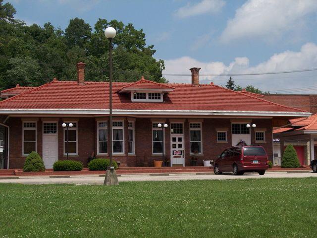
The Olive Hill Depot
Trail Head for the Carter County Rail Trails
 |
Trail Segment Status
 |
The GRAYSON - GOODALE RAIL TRAIL
Routing of the Proposed Grayson to Goodale Trail
The TYGART VALLEY TRAIL
Stone Mountain Construction Site
The Lawton Trailhead area
Olive Hill, West of Ky 174 at US 60
Olive Hill Depot and Trailhead
Olive Hill Train Depot Open House, September 5, 2009
Hayes Property, West of Olive Hill
Brooks Property, South of Devil's Backbone
Sammons Hollow, Across the Tygart, West of Olive Hill to Three Pine
Mountain Top - Cory Road
The LITTLE SINKING CREEK TRAIL
The Louisville Fire Brick Section (Cory Road)
Grahn to Aden (just some Grahn photos now)
Aden - Fultz Fork
The LITTLE SANDY RIVER TRAIL
Fultz Fork - Four Mile
Four Mile - Leon
Leon to Bridge 3
Hill Rd., north of Bridge 3
Bridge 3 to Bridge 2
Bridge 2 to Bridge 1
Bridge 1 to Goodale
Goodale to Hitchins
Hitchins to Denton
Denton - Hogshead Hollow
C&O/CSX Mileage Markers & Deed Images for Current ROW Owners


Lexington MP 642.9 (old Union station)
...
Morehead MP 577.7
....
Triplett Tunnel MP 569
Triplett  MP 568.2
Bradmyr MP 567.9
Hayward MP 567.4
Montague MP 566.9
Shay 566.8

....Carter / Rowan Co. Line....

Soldier

    Deed Book 218, Page 421-427 James Hall, 480' (or more) ROW (ref Garvin Deed Book I, Page 526 & Deed Book I Page 360)
    Deed Book 219, Page 93-98   Joe M. Thompson, 1.5 acres, 650' ROW (Ref. Garvin Deed Book I, page 360)
    Deed Book 220, Page 303-309 Chester Brewster & Dan Tackett, 52' & 86' & 181' ROW (ref. Underwood, Deed Book I, Page  77)
    Deed Book 210, Page 848-854 The Soldier Church of God, 1 acre, 450' ROW  (Ref. Deed Book J, page 360 (?) & Deed Book L, Page 440))
    Deed Book 216, Page 80 Richard Gifford, 7.25 acres, 4044' ROW, probably near Soldier  (ref. Underwood, Deed Book I, Page  79)

Enterprise MP 565.7

    Deed Book 220, Page 303-309  Chester Brewster & Dan Tackett, 1.28 acres, 52' & 86' & 181' ROW
    Deed Book 213, Page 609-615  Randuff Hardin, 1.4 acres, 590' ROW
    Deed Book 213, Page 712-718  Eugene Davis, 2.2 acres, 646' ROW
    Deed Book 214, Page 847-852  Jewell Hall, .5 acres, 215' ROW
    Deed Book 216, Page 568  Curtis Porter, 5.6 acres, centerline of Ky. Rt. 174, 2440' ROW

Tavern Rock MP 564.7

    Deed Book 204, Page 411-417 Othelle Lykins, 3.53 acres, 1,537' ROW
    Deed Book 212, Page 154 - 160  Sherman Clark, near Lawton, 5 acres, 2198' ROW, GVS 1241+37, GVS 1257+02
    Deed Book 225, Page 244-246 Tommy Reynolds, 5 acres, (deed error 10' s/b 100'), 2,198' ROW, Northeast of Sherman Clark land

Lawton Junction MP 564.2

Tygart MP 563.8
Berry MP 563.4
Limestone MP 562.3

Oppenheimer MP 560.6
Koblitzell MP 560.3

    Deed Book 210, Page 697-702 Erwin and Kiser Auto Supply, $500, west of SR 174, lengh of ROW unspecified
    Deed Book 234, Page 548-553 State Route 986 easment, .492 acre
    Deed Book 213, Page 66-71   Qualls Oil Co., .684 acre, east of Rt 174 south of US 60, 312' ROW
    Deed Book 226, Page 728-    Housing Authority, HYDRECO
    Deed Book 216, Page 143 J. C. Raybourn, $1100, 2.2 acres, 950' ROW, east end of Housing Authority parcel

Olive Hill MP 559.4

    Deed Book 202, Page 288-294 First National Bank of Grayson, 14.82 acres, including passenger depot
    Deed Book 234, Page 548-553 Fred Collins, 1260' ROW, OH sewage treatment plant to east Tygart Creek


Atlas MP
Brown’s MP 558.6
Summit Switches MP 556.7
Corey MP 555.5

   Deed Book 213, Page 724-731 Louisville Fire Brick Co., 4.75 acres, 1,530' ROW
   Deed Book 114, Page 694-698 Coleman Binion, $2500, 29.36 acres east of tunnel, "east end of Louisville Fire Brick Parcel", 4,008' or 2,448, MM 553 to 551 ??!

Grahn MP 553.5

Fireclay MP 553.3
Oats MP 553.0
Needle’s Eye Tunnel (Aden Tunnel) MP 552.5
Cannel Coal Co. MP 552.7
Littleton’s MP 552.7

Fultz MP 549.8

   Deed Book 203, Page 266-274 Carter County, parcel 1: 1.5 mile ROW near Music, parcel 2: Fultz 1065' ROW, adjoints track sold to Carter County Fiscal Court

Sinking Creek Tunnel,(Leon)

Elevation 630 ft. MP 549.0

Pope MP 548.1
Leon MP 547.7
Goodale MP 546.0

   Deed Book 197, Page 150-152 Carter County Fiscal Court, 52.83 acres, 3.79 mile ROW, MP 549.79 to MP 546, (Deed Book 195 page 494 citation is an error)

Eastern Kentucky Junction MP 544.7  (Hitchins)

   Book 201, Page 124a- C&O right-of-way related deed - CSX to Madeline Patterson, Straight Creek, $18,000, 25.6 acres, Denton - Hitchins Road, CSX ROW implicitly included

Little Fork MP 544.3
Mt.Savage MP 542.5
Mary Mines MP 541.8
Katy MP 541.6
Strait Creek MP 541.4
EL&BS Junction MP 541.0

Denton MP 540.6

   Deed Book 211, Page 540-546 J. Fraley, 4,467' ROW
  ref. Plat 1, Page 210 "Near Denton"


Burdette MP 539.0

Means Tunnel (Williams Creek Tunnel) MP 538.7
(MP 538)

   Deed Book 203, Page 266-274 Carter County, MP 538, parcel 1: 1.5 mile ROW near Music, parcel 2: Fultz 1065' ROW, adjoints track sold to Carter County Fiscal Court

John’s Rock MP 537.9
Holts MP 537.1

Music MP 536.9
   Deed Book 210, Page 575-580 Bobby G. Fannin, .57 acre, 250' ROW
   Deed Book 210, Page 598-603 Charles Conley, 1.38 acres, 600' ROW
   Deed Book 211, Page 181- Alonzo Horn, 280.5' ROW,

Wards MP 536.1
Morning Glory MP 535.1

Norton Branch MP 534.7

   Deed Book 210, Page 562-?  Edward Fannin, 1.03 acres, 450' ROW
   Deed Book 210, Page 563-568 Danny Brainard, .76 acre, 320' ROW
   Deed Book 210, Page 659-664 Marie Burton, .52 acre, 450' of southern half of ROW
   Deed Book 211, Page 107-112 Sonja Green or Vaughn Thornsberry, 1.56 acres, 680' ROW
   Deed Book 216, Page 154 Grant Holly, .80 acre, Rt. 1654, 350' ROW

Mine No. 10 MP 534.3
Burton MP 533.8

    Deed Book 194, Page 442-448 Addington Inc., Between Coalton and Rush, 2.35 miles near Rush, in Carter and Boyd Co., MP 531.55 to MP 533.7 (near Burton)

Rush Station MP 532.8
(Grant)

    Deed Book 210x, Page 542-546 Earsell Prince, 2.72 acres, 1185' ROW "near Grant"
    Deed Book 210,  Page 621-626 Danny Burton, 4.07 acres, 1774' ROW "near Rush"
    Deed Book 204, Page 332- Cellen & Bonnie Lucas 12.11 acres, Rush(?), 1870' - 4800' m/l
    Deed Book 209, Page 682- Robert Lucas, $2390, 4.9 acres, 2140' ROW

Kilgore MP 532.3

Carter/ Boyd Co. Line

Bailey’s Mine MP 531.5
Coalton MP 530.4   -  abandoned to Coalton

- East of Coalton the line is still in use. Length of abandoned CSX  Lexington to Coalton: 112.5 miles -

Princess MP 528.8 Eastham Tunnel (Princess Tunnel) MP 528.6
Russell MP 528.2
Sturgil MP 527.9
Mead MP 526.3
Summit MP 524.3    (summit of a 3.5 mile climb; grades of .61%- .85%)
May MP 522.3
Winslow MP 522.1
Pollard MP 521.1
Gulfco MP 520.6
Bellefonte MP 520.4
Ashland Tunnel El. 583 ft. MP 520.0
Ashland, MP 519.5   Coal & Iron Junction


C&O/CSX Mileage by County

Fayette Co. - 13.6 miles
Clark Co. - 13.8 miles
Montgomery Co. - 20.2 miles
Bath Co. - 5. 9 miles
Rowan Co. - 19.2 miles
Carter Co. - 37.9 mi
Boyd Co. - 1.9 miles
Lists of ADJOINING Property Owners
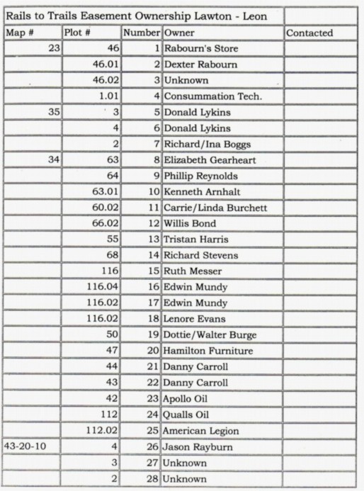
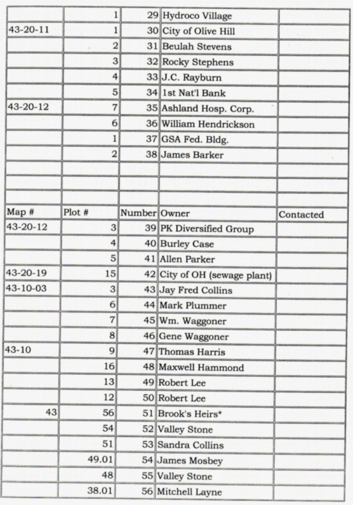
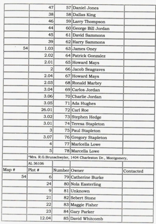
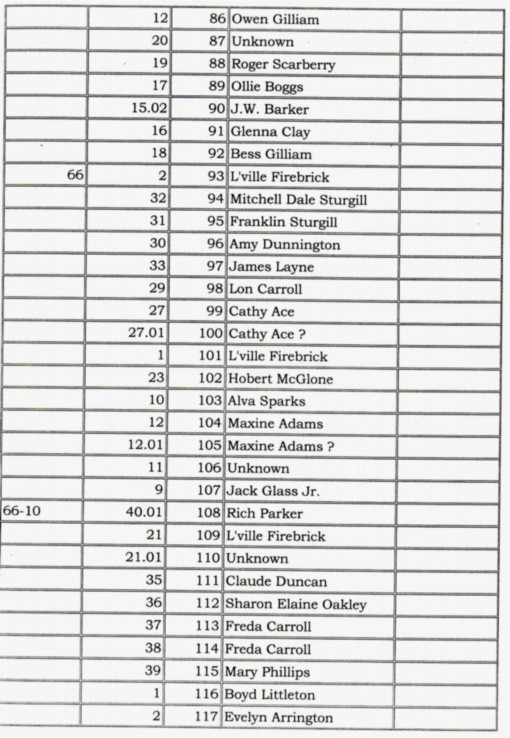
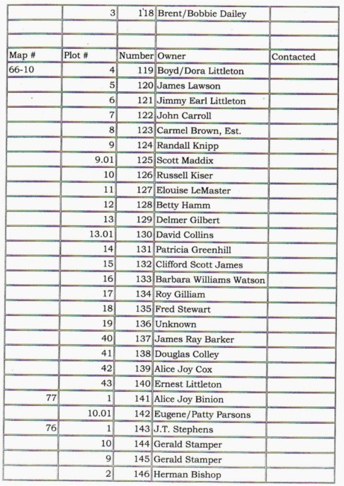
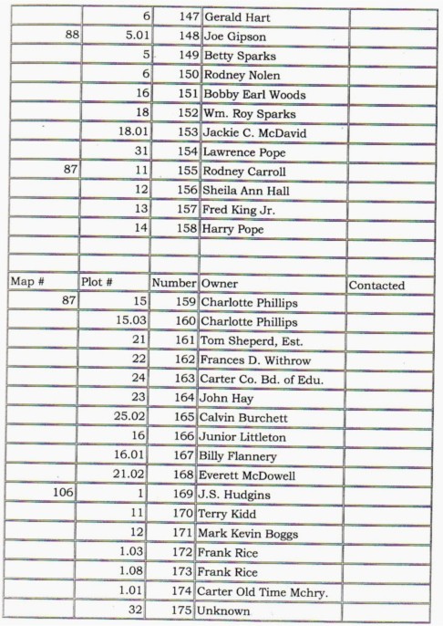
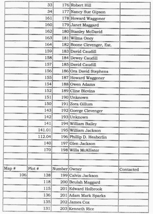
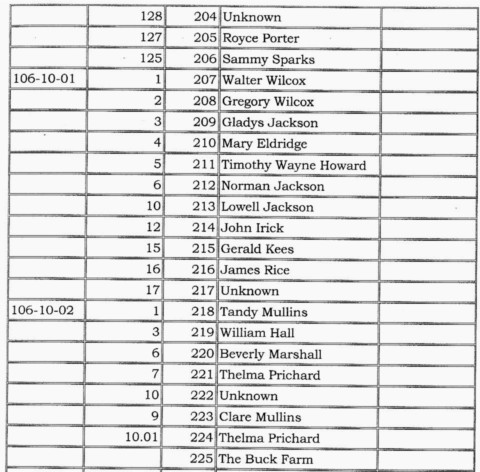
Link to PVA Maps for Properties Abuting the Proposed Trail Right of Way
Our Carter County Trails Guidebook
Our Rails to Trails project brochure
Olive Hill Trail Topo Maps
Our Trail Construction Volunteers
Our Carter County Road Maintenace Dept. Crew
Return to main Carter County page


