The Richard Graham Tracts


246,900 Acres along the Ohio River

These documents represent all of the land that went into the North American Land Company (N.A.L.C.) from Mason Co., Ky.

Source: Historic Indentures
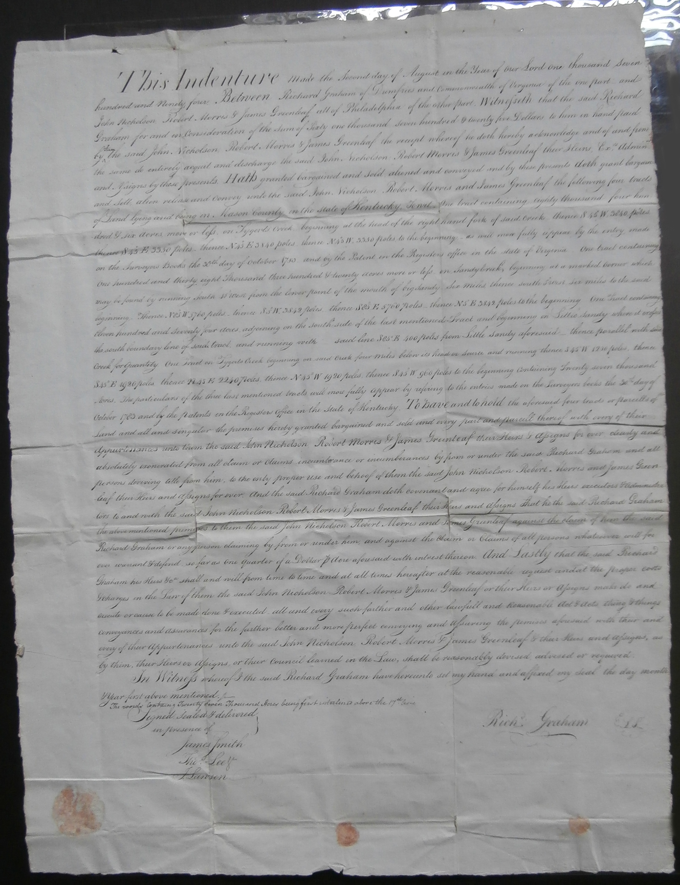
Deed for 246,900 acres, 4 tracts of land along the Ohio River, between Richard Graham to Robert Morris,
John Nicholson and James Greenleaf for $61,725 in Mason County, Kentucky. Signed by R. Graham

This Indenture Made the Second day of August in the Year of our Lord one hundred seven
hundred and ninety four. Between Richard Graham of Dumfries and Commonwealth of Virginia of the one part and
John Nickolson, Robert Morris & James Greenleaf all of Philadelphia of the other part. Witnessith that the said Richard
Graham for and in consideration of the sum of sixty one thousand seven hundred and twenty five Dollars to him in hand paid
by them the said John Nickolson, Robert Morris & James Greenleaf the receipt whereof he doth hereby acknowledge and of and from
the same do entirely acquit and discharge the said John Nickolson, Robert Morris & James Greenleaf their Slun Ex"Admin
and Asigns by these presents. Hath granted bargained and sold, aliened and conveyed and by these presents doth grant bargain
and Sell alien release and convey unto the said John Nickolson, Robert Morris and James Greenleaf the following four tracts
of Land lying and being in Mason County in the state of Kentucky. To wit one tract containing eighty thousand four hundred
& six acres more or less on Tygerts Creek beginning at the head of right hand fork of said creek, thense S 45 W 3840 poles
thense S 45 E 3350 poles, thense N 45 E 3840 poles thense N 45 W 3350 poles to the beginning - as will more fully appear by the entry made
on the Surveyors Books the 30th day of October 1780 and by the Patent in the Regesters office in the State of Virginia. One tract containing
one hundred and thirty eight thousand three hundred & twenty five acres more or less on Sandy Creek beginning at a marked corner which
may be found by measuring South ???? from the lower point of the mouth of the Big Sandy six miles thense south ???? six miles to the said
beginning. Thense N 85 W 5760 poles, thense S 3 W 3842 poles, thense S 85 E 5760 poles, thense N 5 E 3842 poles to the beginning. One tract containing
Eleven hundre and seventy four acres adjoining on the south side of the last mentioned Tract and beginning on Little Sandy where it ???
the south boundary line of said tract and running with said line S 85 E 400 poles from Little Sandy aforesaid, thense parallel with said
creek for quantity One tract on Tygerts Creek beginning on said creek four miles below its head or source and running thense S 45 W 1250 poles, thense
S 45 E 1980 poles, thense N 45 E 2240 poles, thense N 45 W 1920 poles, thense S 45 W 960 poles to the beginning containing twenty seven thousand
acres. The particulars of the three last mentioned tracts will more fully appear by referencing to the entries made on the Surveyors books the 30th day of
October 1783 and by patents in the Registers office in the State of Kentucky. To have and to hold the aforesaid four tracts or parcels of
land and all and singular the premises hereby granted, bargained and sold and every part and parcel thereof with every of their
appurtenances ennumerated from all claim or claims, incumbrance or incombrances by from or under the said Richard Graham and all
persons deriving title from him.


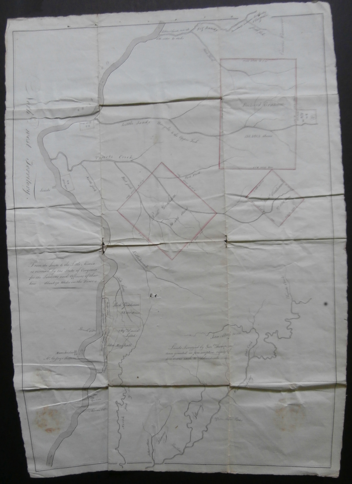
Plan for 246,900 acres in Mason County, Kentucky along the Ohio River. Beautiful sketch of rivers and land
in the Northwest Territories. Surveyed by General Thompson.

Note that North is to the left and East is up on this map

"North Fork" of Tygarts Creek may be Sutton Branch

"West Fork" of Tygarts Creek may be Buffalo-Smith Creek. If it is, then the branches entering it would be Wolfpen Creek, Halfway Branch and Lick Branch.
This happens to be the area of property deeds which refer back to the "Graham Survey"!

The unlabeled creek entering the Tygart from the southeast next to the label "Tygarts Creek" may be Cory Branch.

"East Fork" of Tygarts Creek may be the Soldier Branch

The course of the upper reaches of Tygarts Creek must have been guesses, since Tygarts Creek flows west to east from its source,
rather than from the south as it is depicted on this map. The smallest tract on the south is in the Globe-Upper Tygart area.

Kinniconick Creek in Lewis County is mislabeled on the map as "Killikinick"

The small creek on the right margin of the map, btween the second and third creases is Tripletts Creek

The long river that flows off the map in its lower center is definitely the Licking River.

The second watercourse to enter the Licking River is Fox Creek, flowing in from the northeast.

Next of the map is the legend "Land surveyed by Geo. Thompson since granted in fee simple....each to individuals"

The creeks flowing into the Little Sandy are more difficult to identify.
The first one flowing in from the east is probably East Fork and the second one farther upstream is Little Fork.
The present city of Grayson is probably located is probably located above the "N" in the label "Navigable to the upper fork" .
That would place the large southerly tract (in the upper right) in Elliott County.

The small rectangle located where the Little Sandy River flows into the Ohio River is probably Riverton.
The railroad connecting central Carter County to the Ohio terminated at Riverton. It has since largely disappeared,
with Greenup (aka "Greenupsburg") having grown to supercede it on the opposite (eastern) side of the Little Sandy.

The Scioto River enters the Ohio from the north. The rectangle on the map on the south side of the Ohio later bacame South Portsmouth.

Somewhat oddly, the Big Sandy River (at the top of the map) is shown as an inconsequential waterway,
when in fact it is several times as large as the Little Sandy River.

It may be also noted that no overland routes are marked on this map.

Submitted by: John W. Grace

 Back to Your Carter County Deed Index page