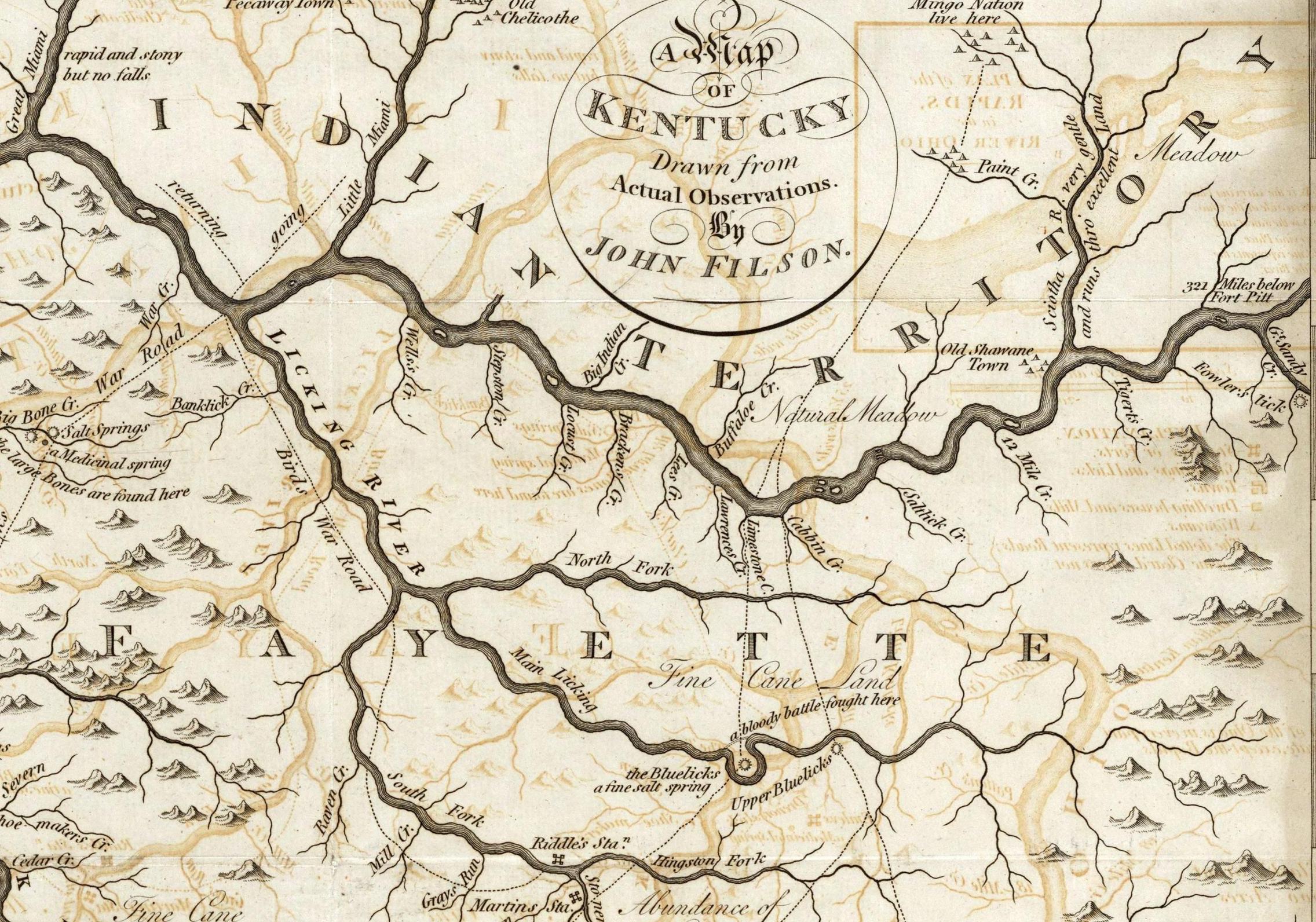
1784 John Filson Map
What would some day become Carter County is in the headwaters of the "Tigert's Creek" - "Fowler's Lick" area of the map.

There are several notable features on this map: Note that it highlites the sandy shoals that once dominated the Ohio River before it was damned and channelized. Today's Little Sandy River, which flows through modern day Grayson, Ky. is identified as "Fowler's Lick" Even on this early map, "Tigert's Creek" carries the name we are familiar with. "12 Mile Creek" seems to approximate the location of today's Kinniconick Creek which joins the Ohio River at Garrison, Ky. In our area of Kentucky, the only river that looks like the author actually navigated was the Licking River. Because of it's strong water flow, the Licking was one of the main north-south thoroughfares in pre-European times. Notice the marked route of the "War Road" along the Licking River. Similar ancient trails are indicated along "Limestone Creek" (probably the modern day Maysville, Ky. area) and "Cabbin Creek" to the east. Although not noted on this map, ancient trails followed both Tygart's Creek and the Little Sandy. They were used to travel between the eastern Kentucky hunting grounds and Scioto River (which in turn led to the major village at Chillicothe, Ohio and other permanent Native American settlements to the north). Note the "321 miles below Fort Pitt" (modern day Pittsburg, Pa.) legend in the upper right corner of the map, and the "Fine Cane Land" inscription at the bottom (today's Lexington-Winchester area). Note the "Natural Meadow" north of the Ohio River. I'm not sure what this refers to. The area is largely rolling hills. There is no reference the large Native American settlement that was known to have existed at modern day Ashland, Ky. Obviously the "North Fork" of the Licking River is drawn much too long and confuses the geography somewhat. But still, not bad considering the wildness of the landscape and the technology of the era. As indicated, our region was part of "Fayette County" at the time the map was drawn. Note also the "Old Shawane Town" just west of the Scioto River.- From Wikipedia.com Shawnee village Located at the mouth of the Scioto River, this was one of the earliest known Shawnee settlements on both sides of the Ohio River. Although mainly a Shawnee village, the population included contingents of Iroquois and Lenape, and a few British and French traders. It was established in the 1730s and was a major village until 1758. One account from 1750 described it as a community of 300 men, iindicating a total population of around 1,200. The town consisted of 40 houses on the Kentucky side and 100 houses on the Ohio side, including a 90 feet (27 m) long council house. In the summer of 1749 Pierre Joseph CÚloron de Blainville moved down the Ohio River on his "Lead plate expedition," burying lead plates at locations where major tributaries entered the Ohio. The plates were inscribed to claim the area for France. He stopped at Lower Shawneetown, where he demanded that the British traders leave, although most refused to do so. In January 1751 the British traders Christopher Gist, George Croghan, Andrew Montour, and Robert Kallendar recorded their visit to the village. The town was a key center in dealings with other tribes and with Europeans before it was abandoned in 1758.
- An explanation of the map carries the comment: "Large foldout map of Kentucky showing stations, forts, salt springs and licks, towns, dwelling houses, mills and "wigwams". The river passages are described and historical information is included , i.e. "a bloody battle fought here." and "Drawn from Actual Observations. By John Filson. (with) A Plan of the Rapids, in the River Ohio. Published Novr. 23, 1793, by John Stockdale, Piccadilly. Full_Title A Map of Kentucky, Drawn from Actual Observations. By John Filson. (with) A Plan of the Rapids, in the River Ohio. Published Novr. 23, 1793, by John Stockdale, Piccadilly."