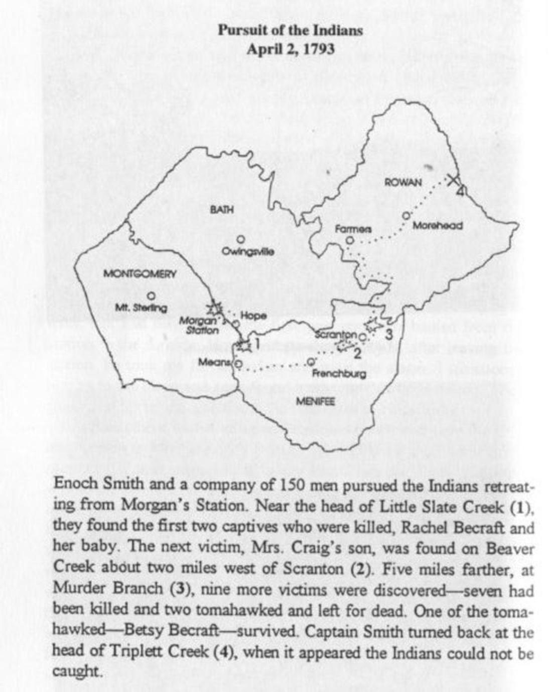

Map from the book "In Search of Morgan Station"

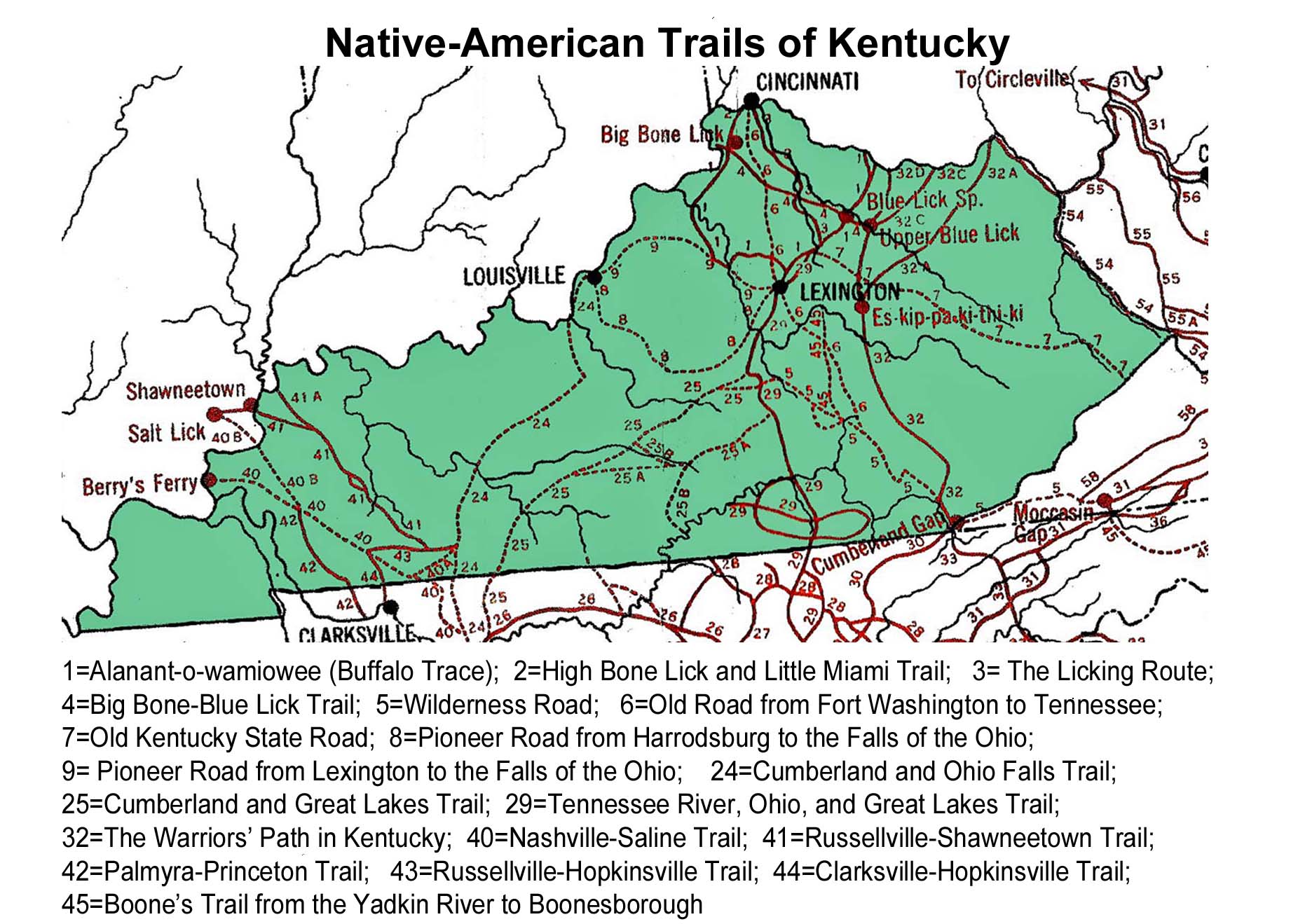
Working representation of trails
Research paper on Native American migration trails
				“Walking Ancient Kentucky”

		An essay on travel across the Kentucky landscape


The pre-contact Kentucky landscape was in no way a mysterious land to Native Americans. Walking across the
length and width of Kentucky was probably not unlike driving across it today with the aid of a good map.
Kentucky had been thoroughly traveled by individual clans for generations, and by Native Americans for hundreds
of generations. Such an historic experience inevitably instills great familiarity.

Although the Europeans who first made contact with native Americans learned of some of the pathways across the
Kentucky landscape, and a few of them were preserved in the form of these maps, the actual number of known trails
was probably nearly infinite. The hills and hollows of Eastern Kentucky were as familiar to the Native American
hunters of Eastern Kentucky as our local modern day parks are to us. They were not limited to crossing the land
on the narrow strips of public highway we use today, and they did not pass through it at 70 miles per hour.

Their knowledge was based on an intimacy gained by walking freely across a land without fences or private property line boundaries.
The freedom of movement that they experienced then without question, is nearly incomprehensible to us today.

As the Kentucky landscape is viewed from the perspective of the walker, a directed trip across it must contain
a certain timeless rationality to it. A hunter may wonder the hills randomly in search of game or refuge,
but the traveler will seek out the most efficient course through the land. There will be a balancing between
seeking the most direct route to a destination against the need to avoid unnecessary expenditures of energy and
risk. One will tend to walk along streams, not so much in their meanders, but surely along their floodplains,
because climbing and descending hillsides demands more energy and increases the risk of injury. Long distance
walking requires regular hydration and even small quantities of water are heavy to carry. Pathways would surely
follow along every watercourse that led in the general direction of the ultimate destination.

Assuming these basic assumptions allows us to make educated guesses about how Native American trails crossed
the Kentucky landscape as we view it in our own time.

The trails on these maps were analogous to the interstate and state highways of today. These were the pathways
between relatively distant points. We can see that many of the ancient paths followed a north – south orientation
through Kentucky. This was in part dictated by the need to traverse Kentucky to and from the more heavily
populated areas of Ohio, but also because the watershed of the river that dominates this part of America, the
Ohio, flows from northeast to the west. Dozens of the Ohio’s tributaries flow into it from the south and from
the north. Many of the known Native American trails followed along these same Kentucky tributaries that to this
day find their way northward into the Ohio River from the interior of Kentucky. In our part of the state, these
include the Big Sandy River, the Little Sandy River, Tygarts Creek and the Licking River.

From the standpoint of travel efficiency, all other things being equal, travel by canoe was always preferable to
walking. Movement by canoe is faster, less energy is expended, far greater burdens can be transported by
relatively fewer individuals and many dangers are avoided on the water.

That said, not all waterways were equally useful to the ancient traveler. A watercourse that had depth
sufficient to allow movement by canoe was preferable to one that did not.  The Eastern Kentucky rivers and
creeks that empty into the Ohio increase in water flow volume as one draws closer to their confluence with the
Ohio. With the exception of the Big Sandy,  Eastern Kentucky watercourses are all characterized by points where
upstream travel by canoe becomes untenable due to low water. We may assume that some walking paths would tend to
converge on navigable waterways at the point where water depth was sufficient to support canoe travel.
Obviously there could be a degree of variation depending on seasonal rainfall and their effects on stream flow levels.

				Managing the Pre-Contact Environment

For many years, it was assumed that many Native American trails followed the seasonal American bison migration
routes from the Kentucky southeast into the broad grasslands of central and northern Ohio. This was based on
observations of the vast herds of the Great Plains west of the Mississippi, and early European discovers of
deeply warn pathways through the wilderness that they found great beasts following to and from salt licks of
Eastern Kentucky. More modern research has concluded that the arrival of the American bison actually post dated
human habitation of the area.

It seems that early humans experienced Eastern Kentucky as a nearly impenetrable wooded wilderness, full of
small game, but not a favorable environment  for sustaining significant numbers of large grazing animals.
The consensus is now that early man managed our environment not unlike the way it has been managed by
European-Americans. Native Americans no doubt recognized the limitations of our hilly terrain and used fire to
create open grassy bottom lands that attracted large game animals, and facilitated the hunting of them.
Before Native Americans were driven from Eastern Kentucky, many areas may have been nearly as treeless as the
lands of small farms and meadows that we are so familiar with today. Fire would have been a powerful device for
environmental management in the hands of intelligent and motivated tribes people.

To be continued....


Map from the book "In Search of Morgan Station"

Working representation of trails
Research paper on Native American migration trails