Jackson Purchase Image Page
This page is for the use of the subscribers of the KYJacksonPurchase-L, KYGraves-L, KYMarsha-L, KYCallow-L, KYBallar-L, and KYHickma-L mailng lists, and visitors to the Graves, Calloway, Marshall, Hickman, Ballard, McCracken, Fulton and Carlisle County KYGenWeb Pages. It contains JPEG and other forms of image files showing various maps of the Jackson Purchase area, as well as line drawings and other images of interest to those researching the Jackson Purchase counties (Calloway, Marshall, Graves, Fulton, Hickman, Ballard, Carlisle and McCracken). These are LARGE Files - please allow ample time for them to load. AOL users may have difficulty in loading these files on the AOL browser.Questions about any image on this page should be addressed to Bill Utterback, Host of the KYJacksonPurchase-L Mail List and Host of the Calloway & Fulton County KYGenWeb pages. If you are not a subscriber to the KYJacksonPurchase-L Mail List and would like to become one, click on the mail link below. When the mail window appears, place the one word SUBSCRIBE in the message area of the mail window and send the message. You will automatically be subscribed.
Go To Mail Window
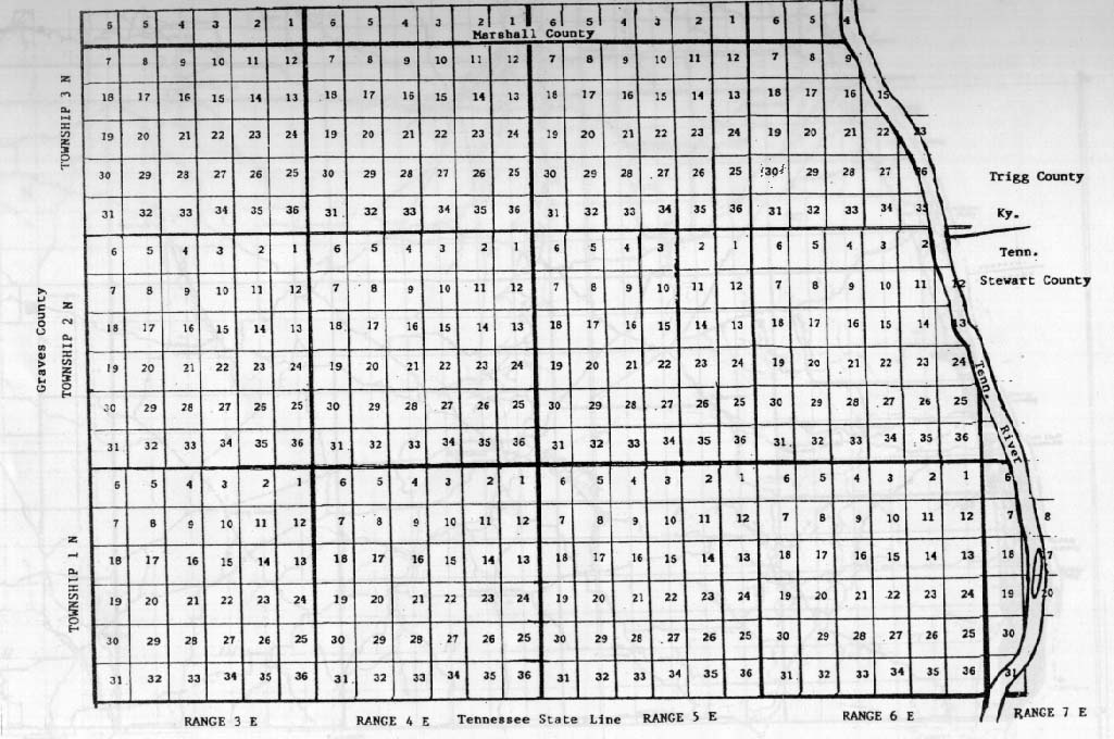
To view the Calloway County Rectangular Survey Grid Map, click here
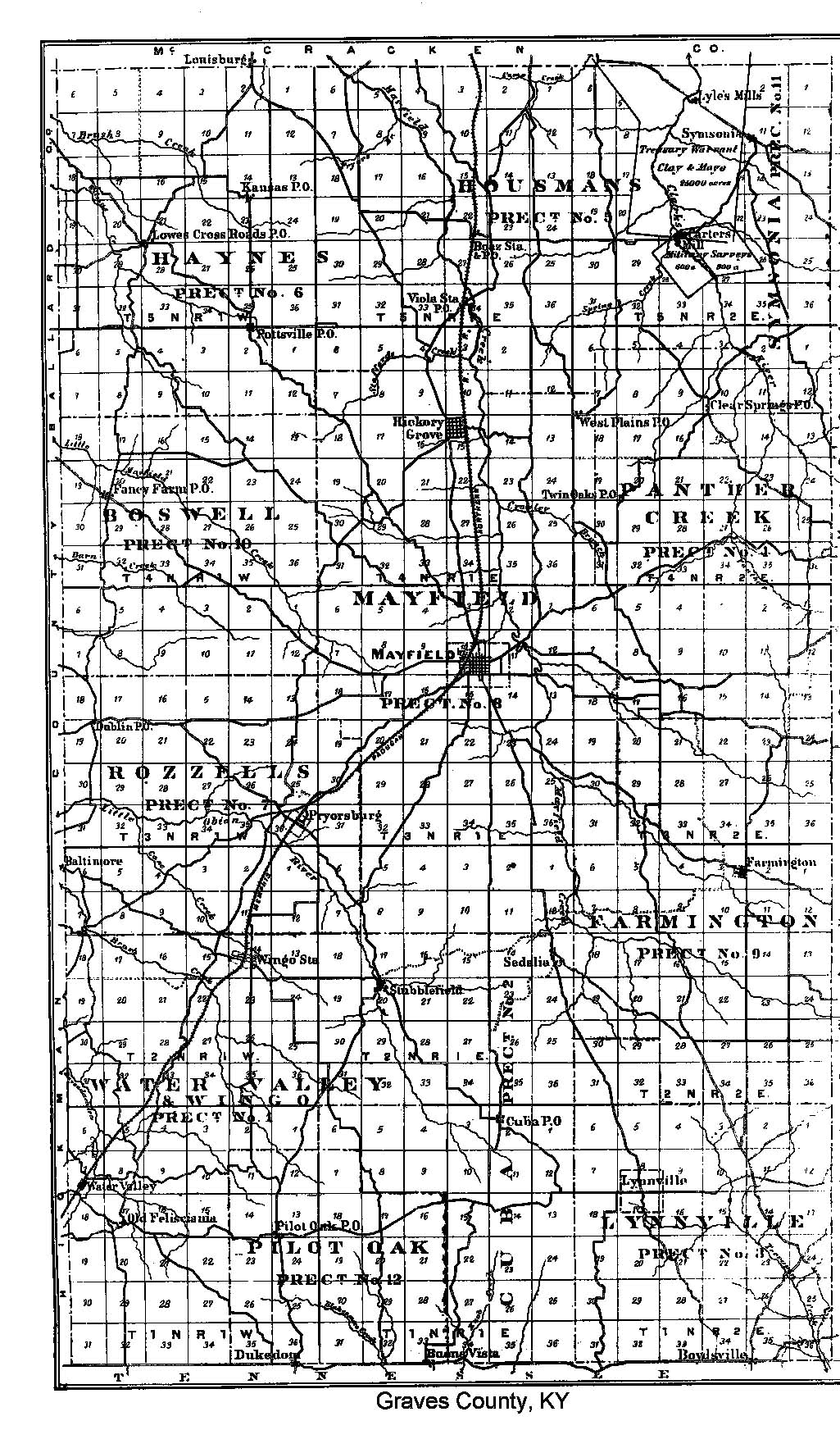
To view the Graves County Rectangular Survey Grid Map, click here
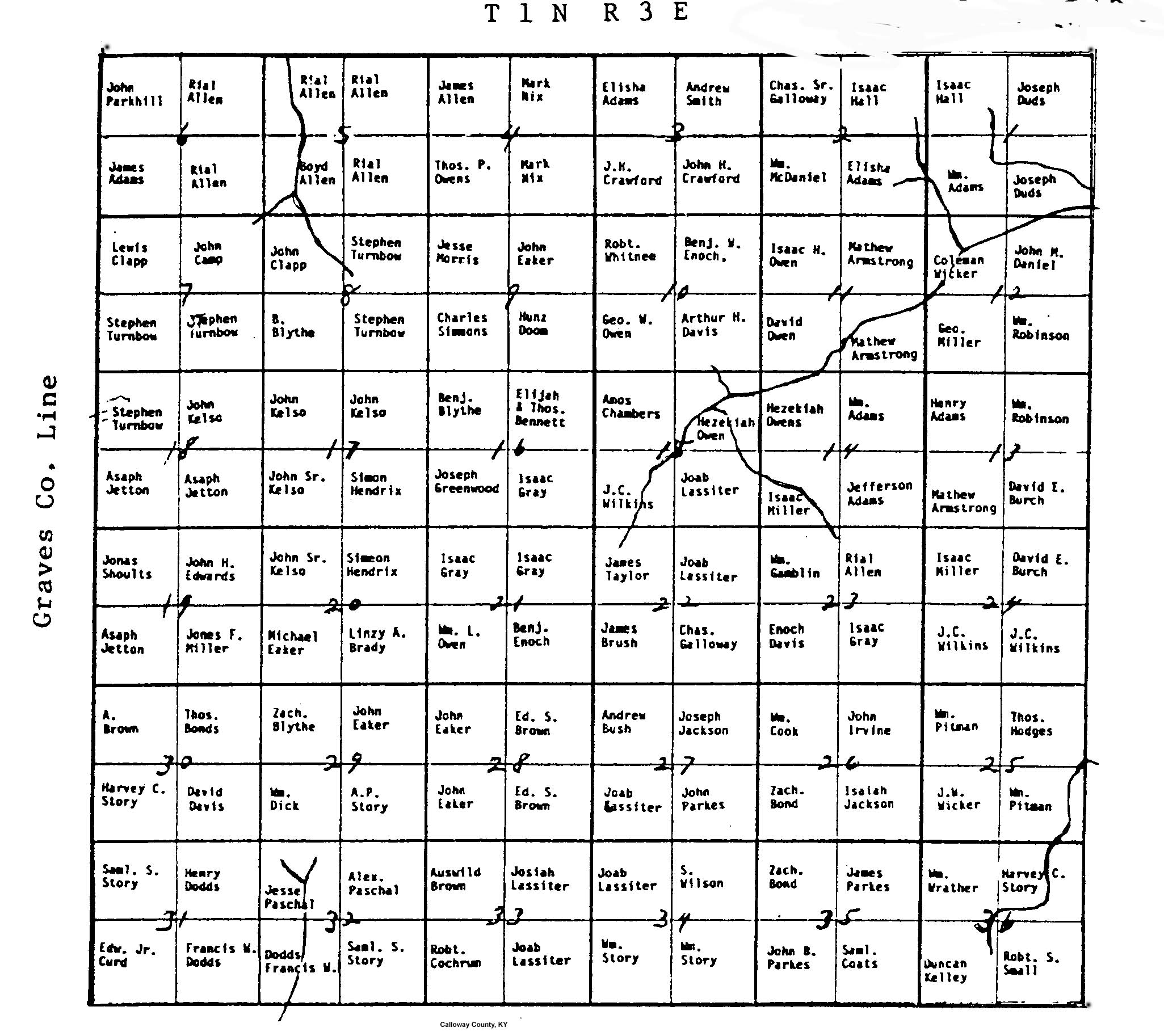
To view an image of the Rectangular Survey Grid of Township 1, Range 3 East (SW Calloway County), with the names of the first grantee shown in each quarter section, click here.
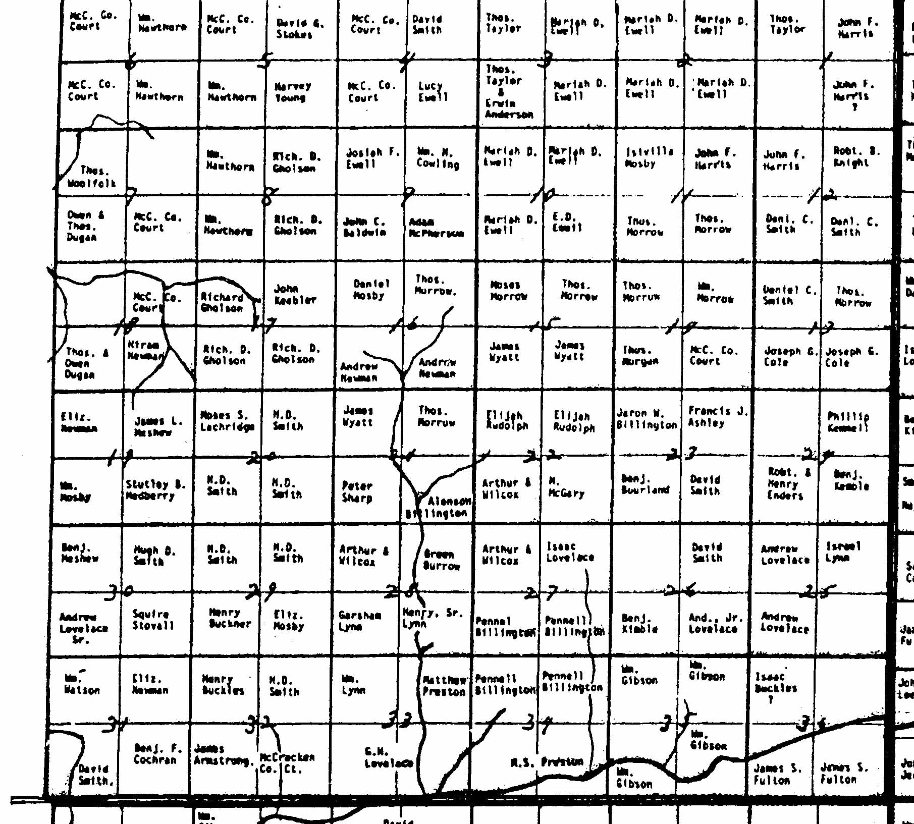
To view an image of the Rectangular Survey Grid of Township 3, Range 1 East (central part of Graves County), with the names of the first grantees shown in each quarter section, click here.
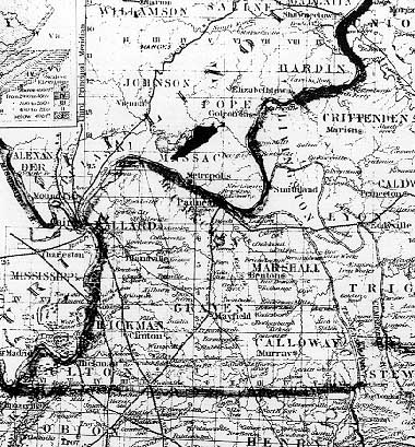
To view an image of the entire Jackson Purchase with township and range lines (albeit dim) from the 1880 Graves County Atlas, click HERE.
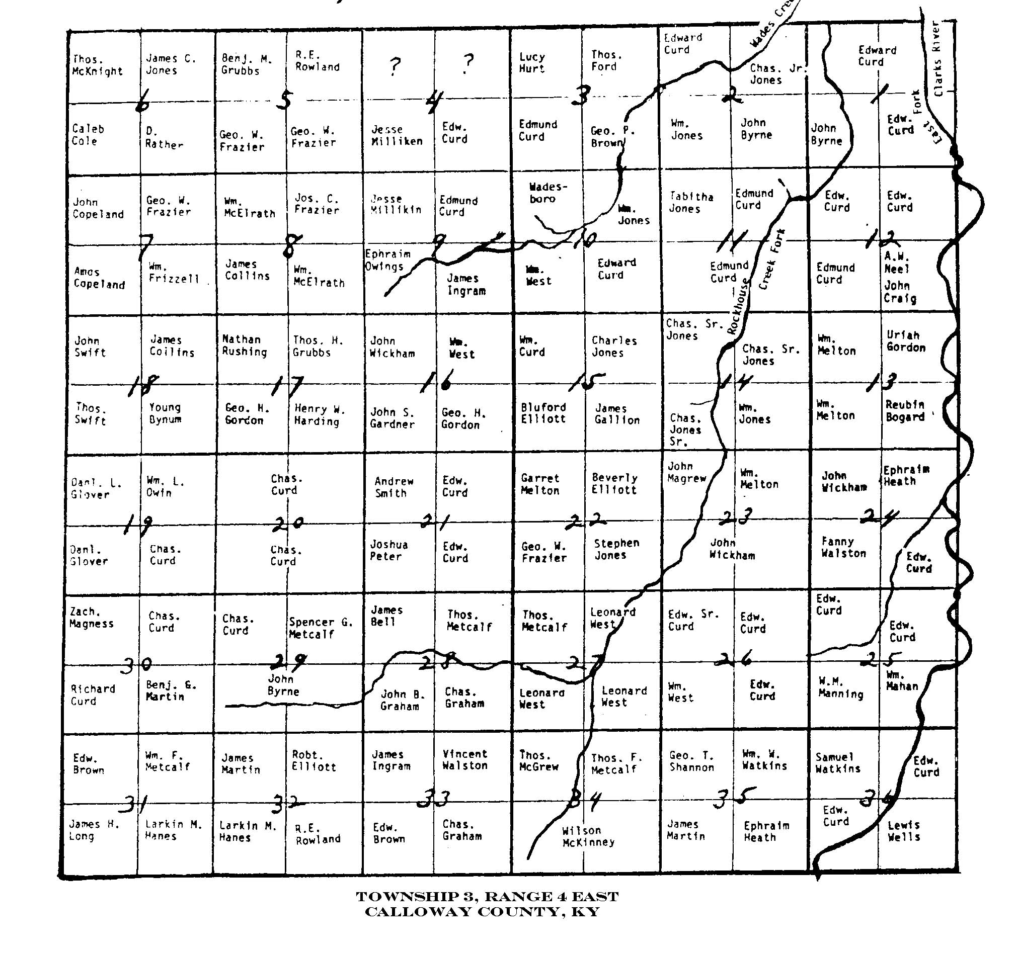
To view an image of Township 3, Range 4 East, with original landowner grantees named shown (North Central Calloway County, including the Wadesboro area), click HERE
To view an image of Township 1, Range 6 East (southeast part of Calloway County), with original land grantees names shown, click HERE
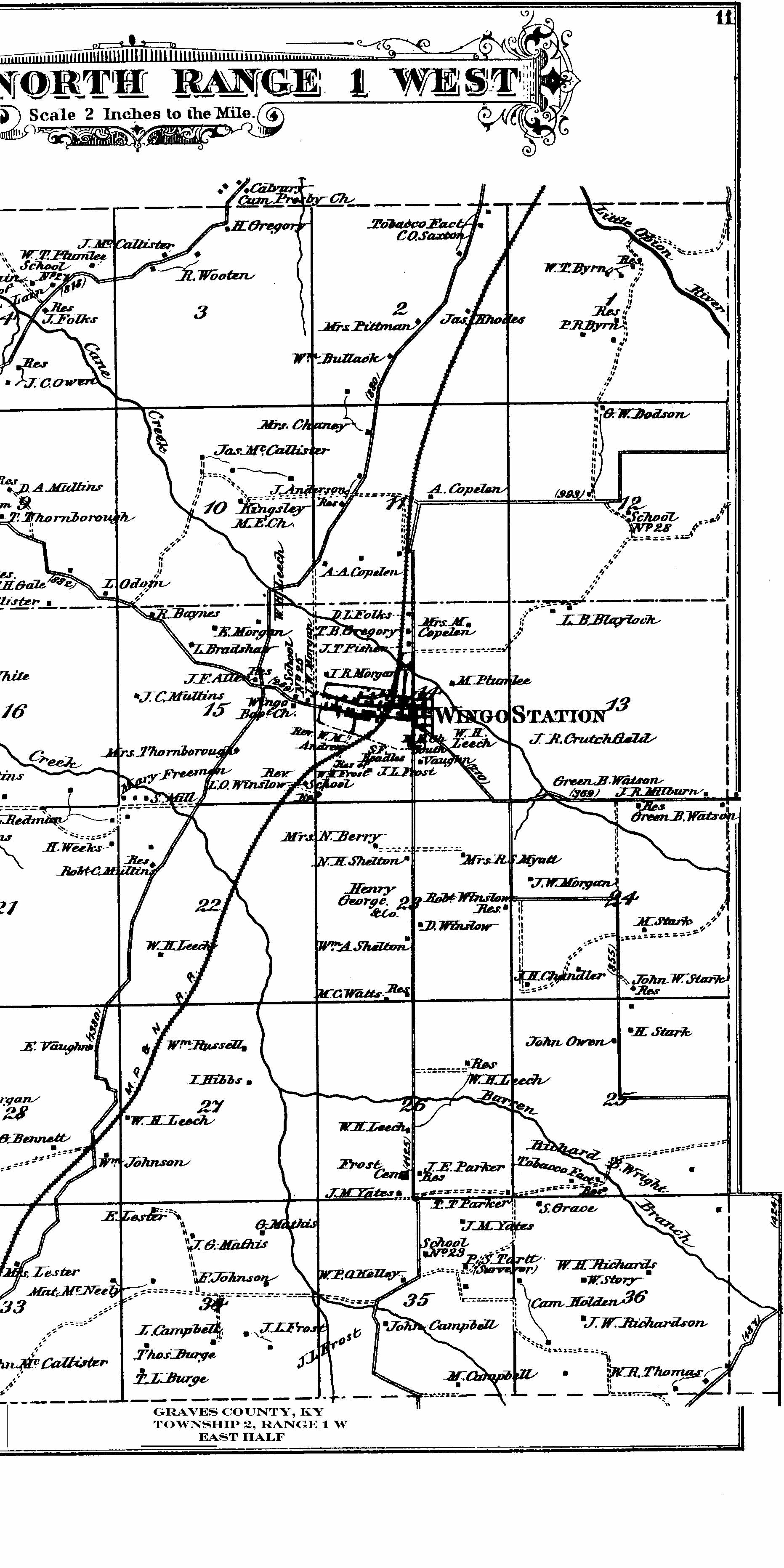
To view an image of Township 2 Range 1 West (Graves County - Wingo area and westward), as depicted in the 1880 Graves County Atlas, with landowners shown, select one of the following: To view the west half of the township, click HERE
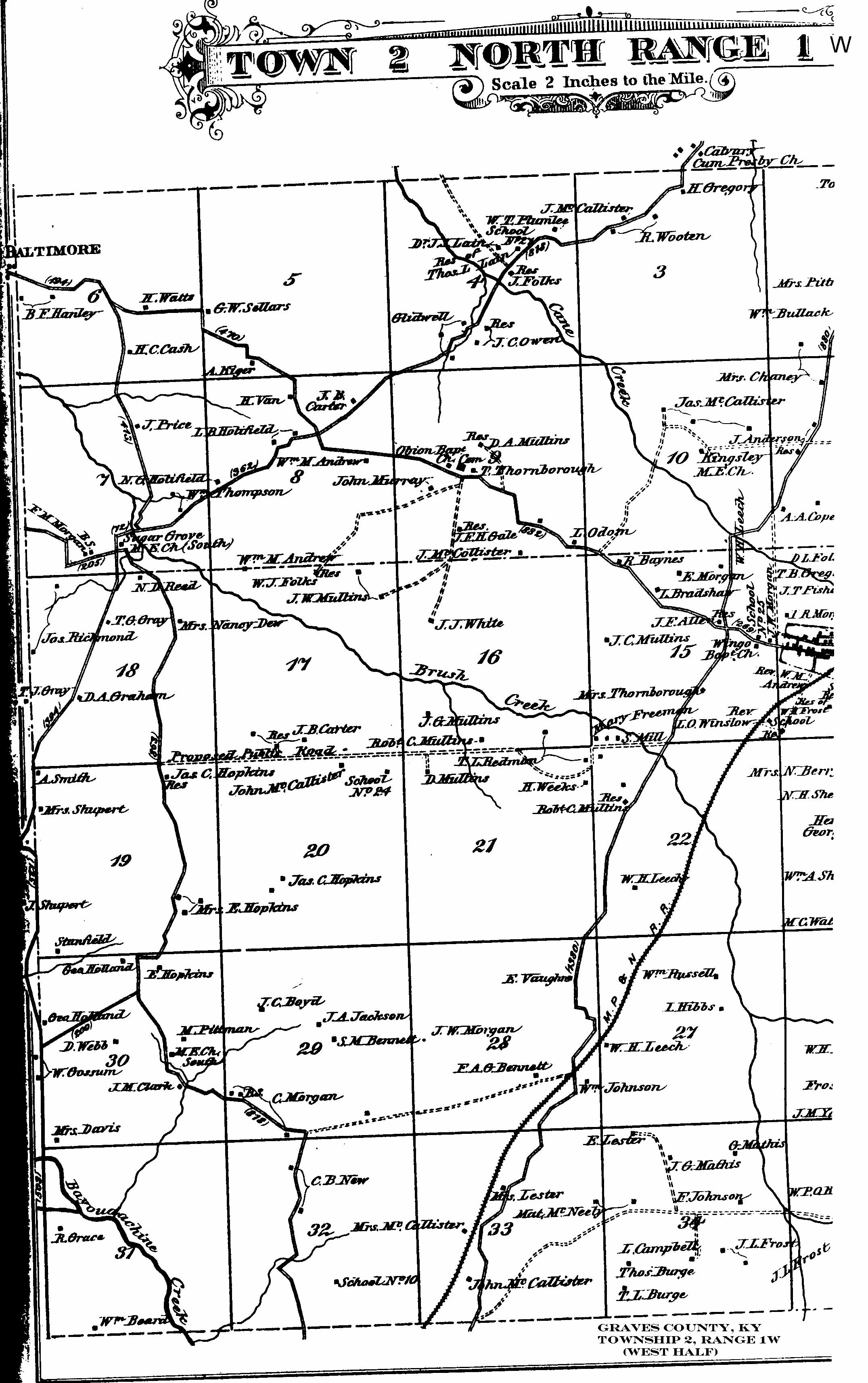
To view the east half of the township, click HERE
To view an image of Township 1, Range 1 East (Graves County - Cuba, Buena Vista and area in between), as depicted in the 1880 Graves County Atlas, with landowners shown, select one of the following: To view the West Half of the Township, click HERE
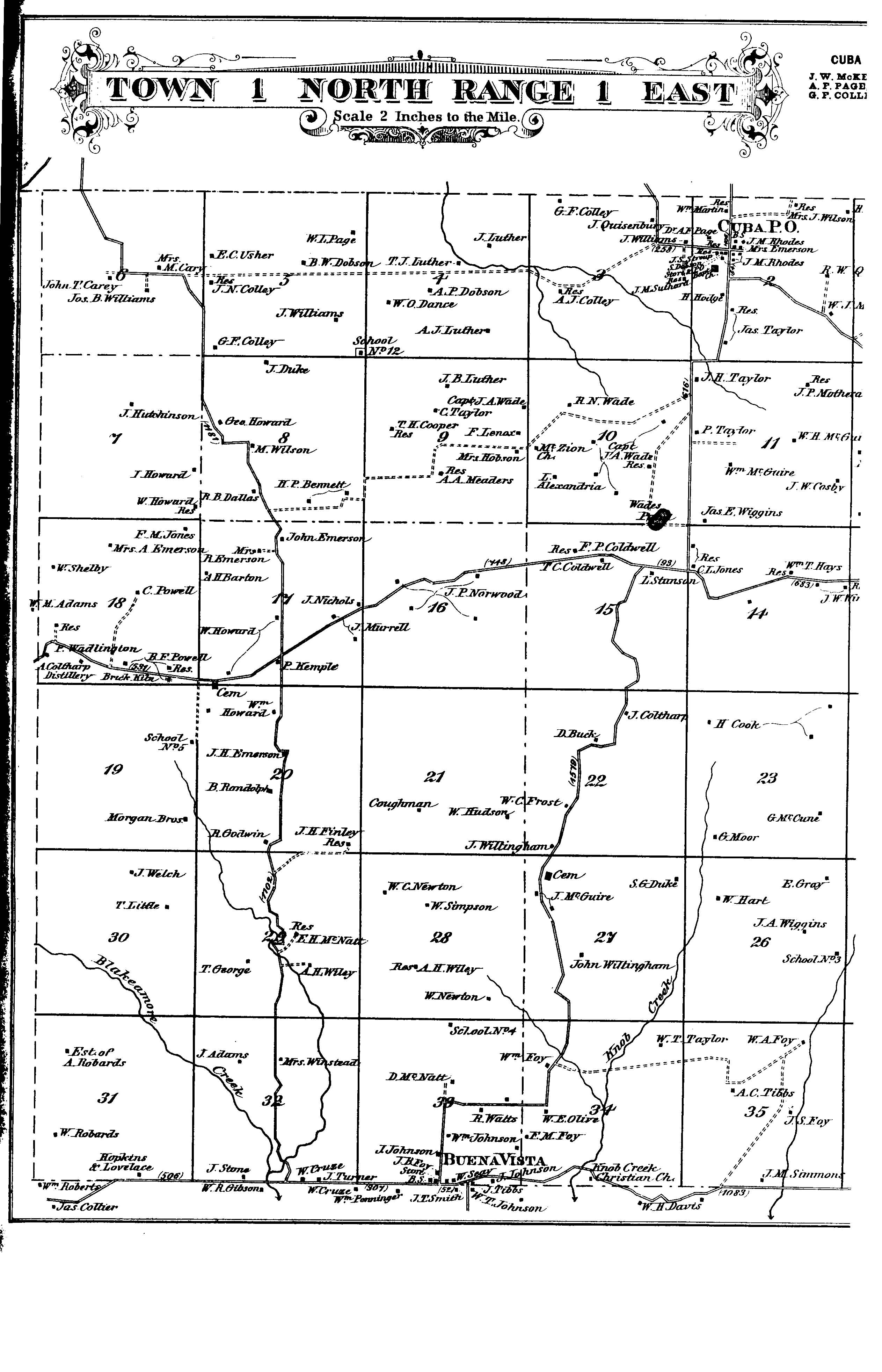
To view the East Half of the Township, click HERE
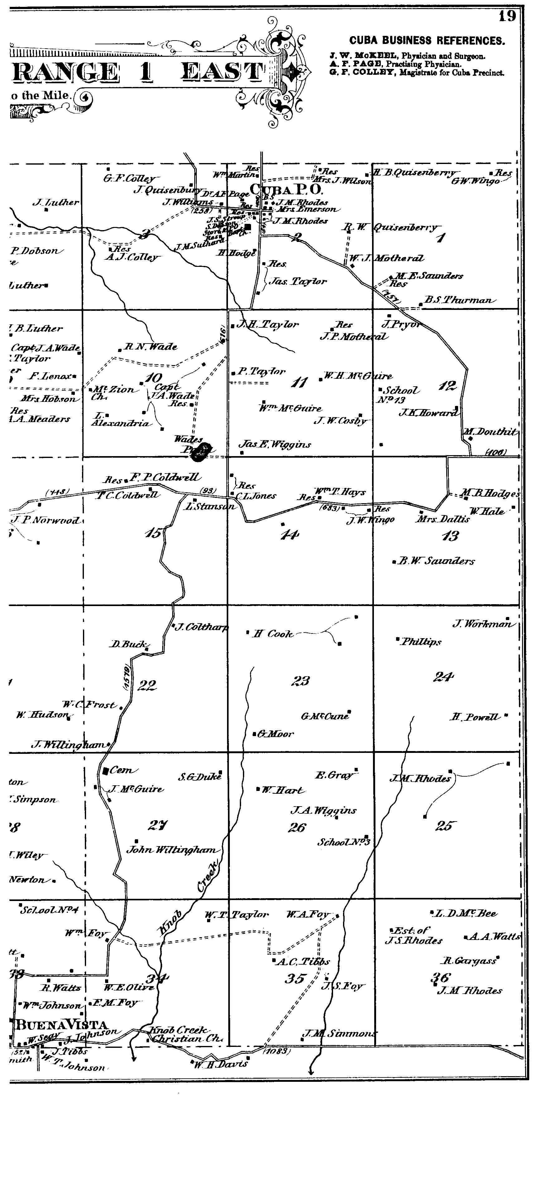
To view an image of Township 5 Range 1 West (Graves County - Lowe's Cross Roads, Kansas Post office and north), as depicted in the 1880 Graves County Atlas, with landowners shown, select one of the following: To view the west half of the township, click HERE
To view the east half of the township, click HERE
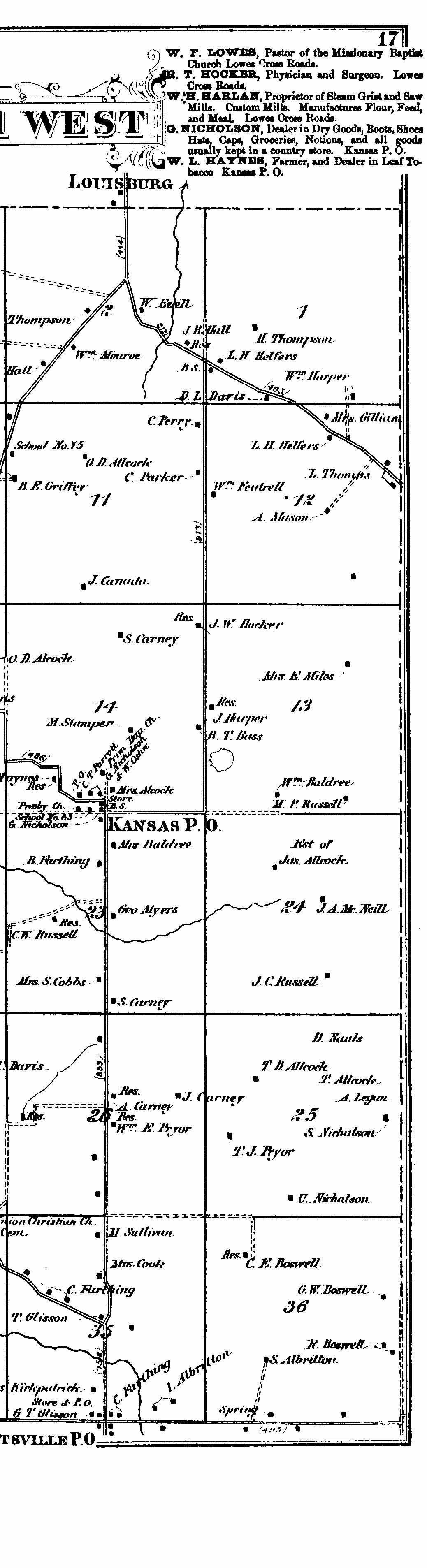
To view an image of Township 1, Range 2 East (Graves County - Lynnville and east and south), as depicted in the 1880 Graves County Atlas (with land owners shown), select one of the following: To view the west half of the township, click HERE
To view the east half of the township, click HERE
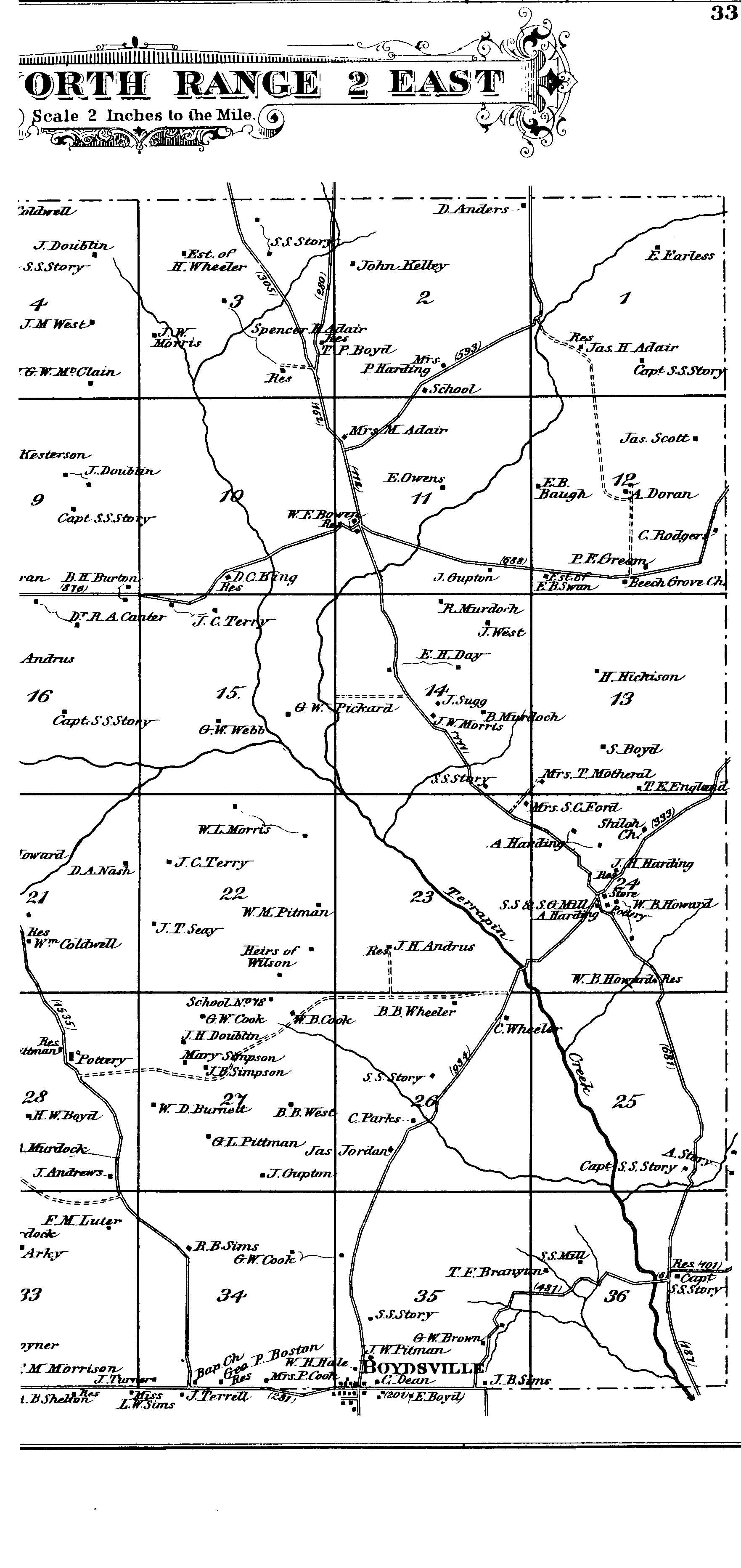
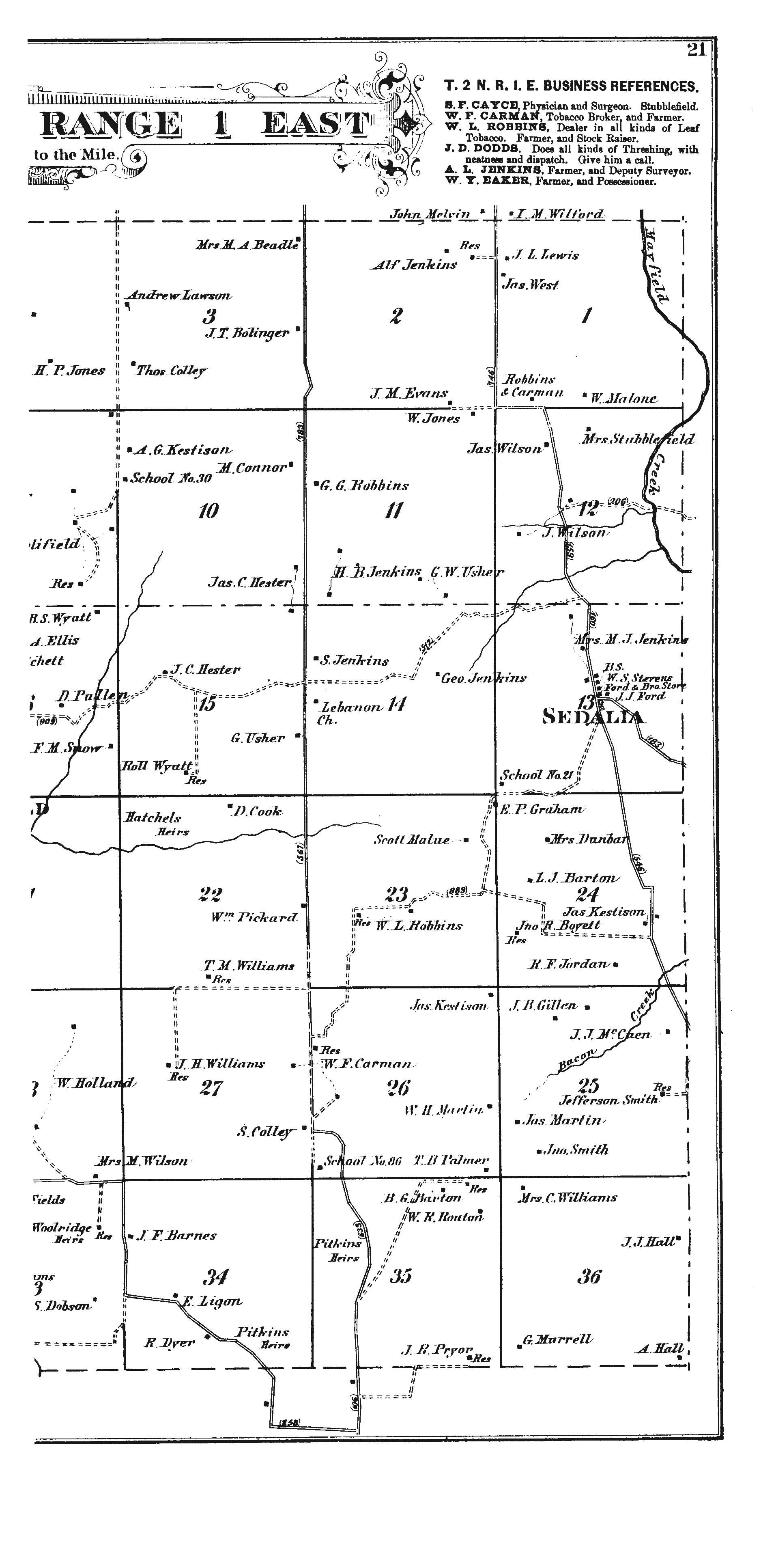
To view an image of Township 2, Range 1 East (Graves County - includes Sedalia and Stubblefield), as depicted in the 1880 Graves County Atlas (with land owners shown), select of the the following: To view the west half of the Township, click HERE
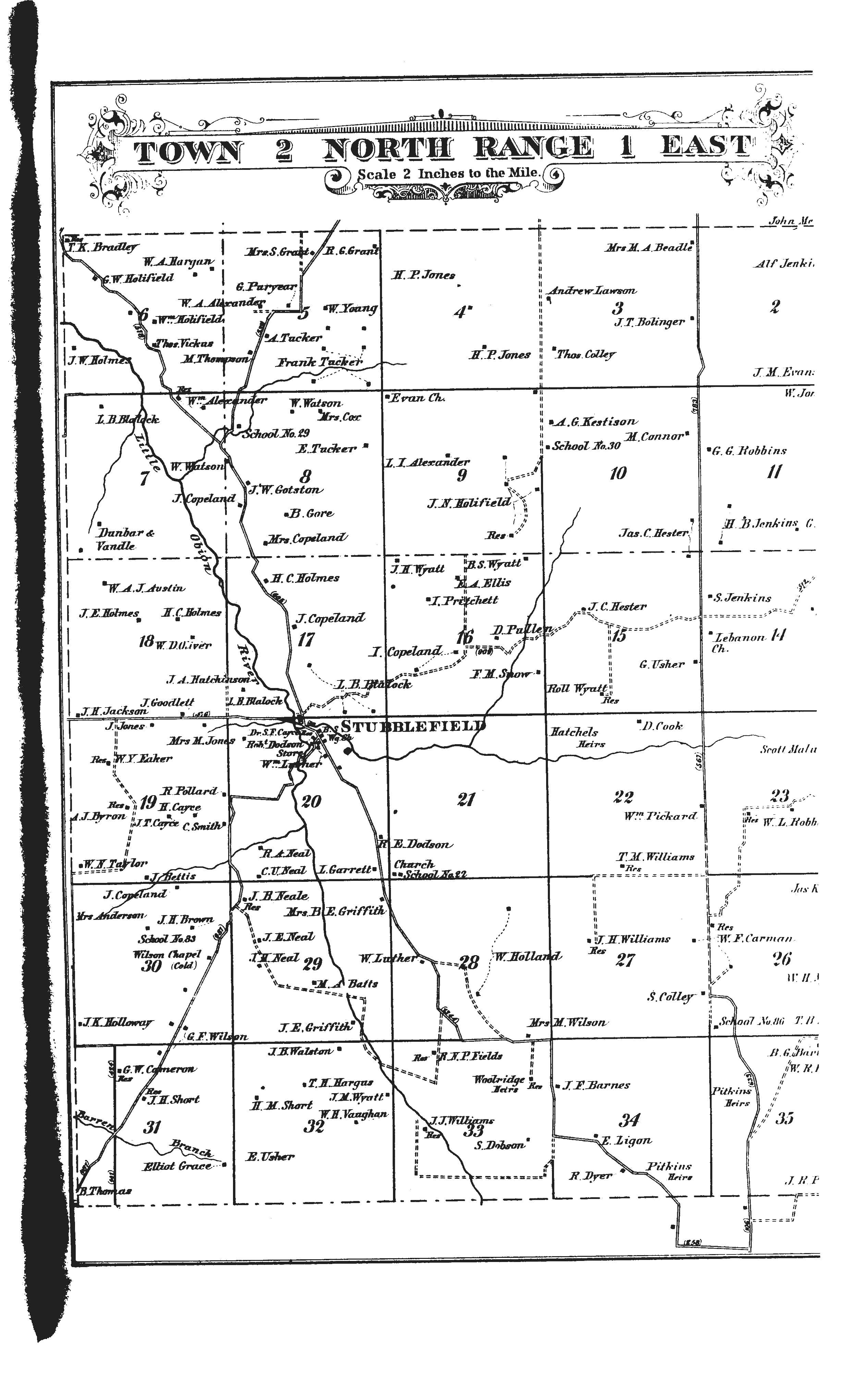
To view the east half of the Township, click HERE
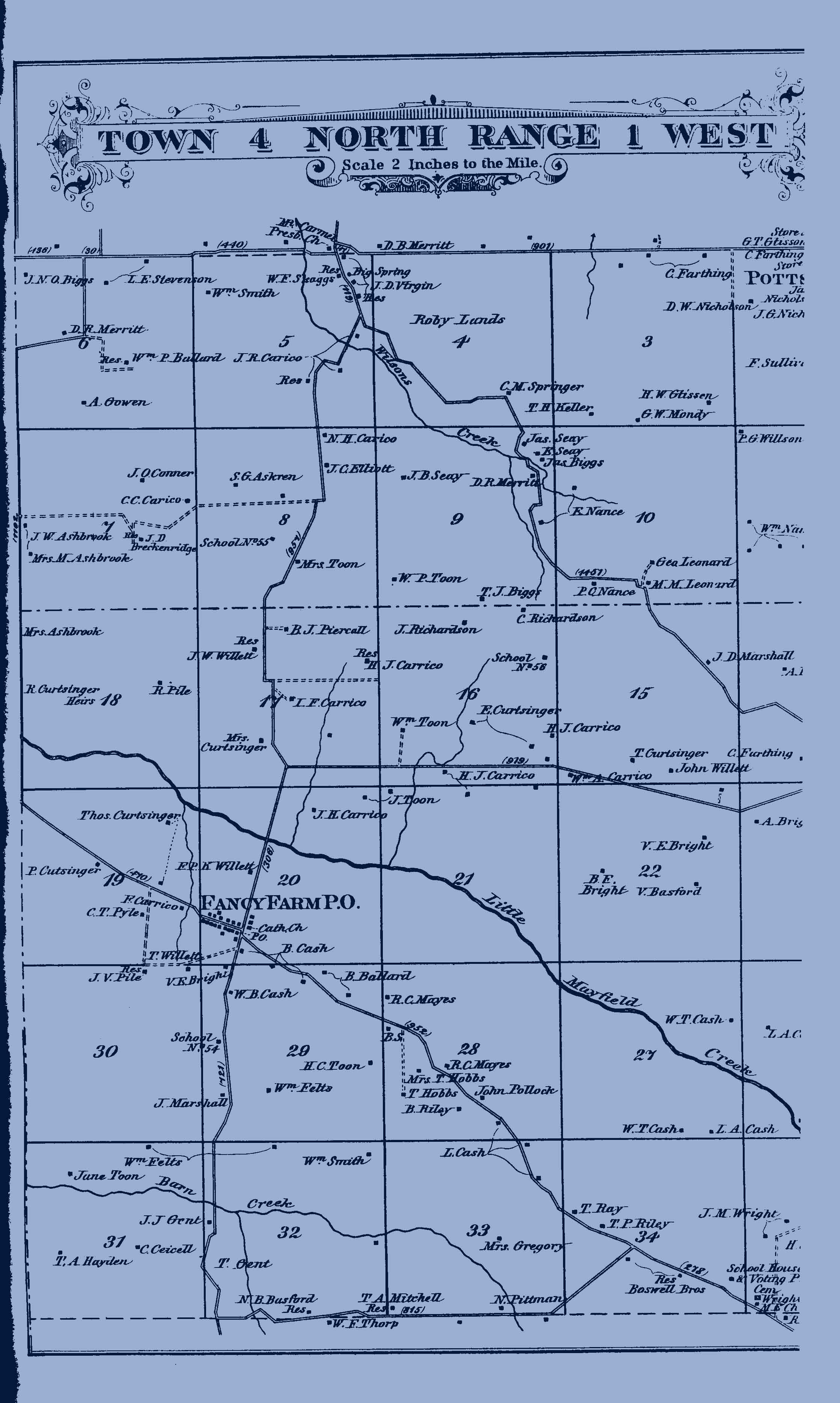
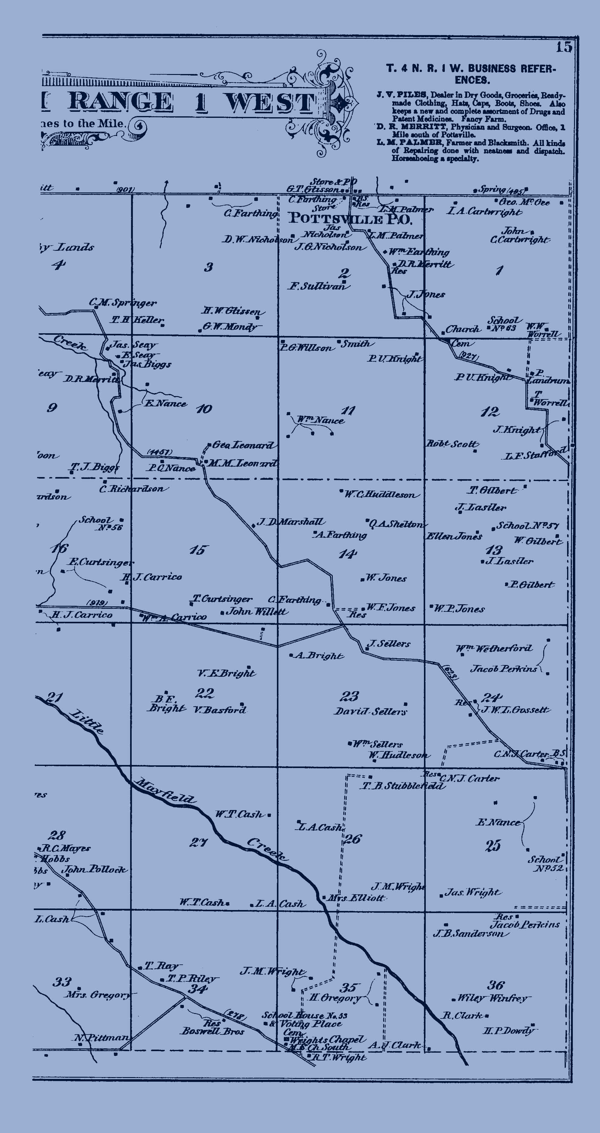
To view an image of Township 4, Range 1 West (Graves County - Fancy Farm area and north and east from that point), as depicted in the 1880 Graves County Atlas (with land owners shown), select one of the following: To view the west half of the Township, click HERE
To view the east half of the Township, click HERE
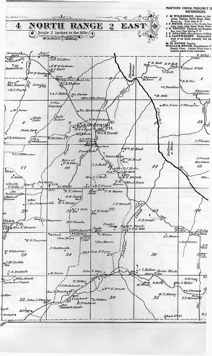
To view an image of Township 4, Range 2 East (Graves County - Clear Springs, Twin Oaks, West Plains area), as depicted in the 1880 Graves County Atlas (with land owners shown), select one of the following: To view the west half of the Township, click HERE
To view the east half of the Township, click HERE
To view an image of Township 5, Range 2 East (Graves County - Symsonia, Carter's Mill, Lyles Mill and southwest and southeast), as depicted in the 1880 Graves County Atlas (with land owners shown), select one of the following: To view the west half of the Township, click HERE
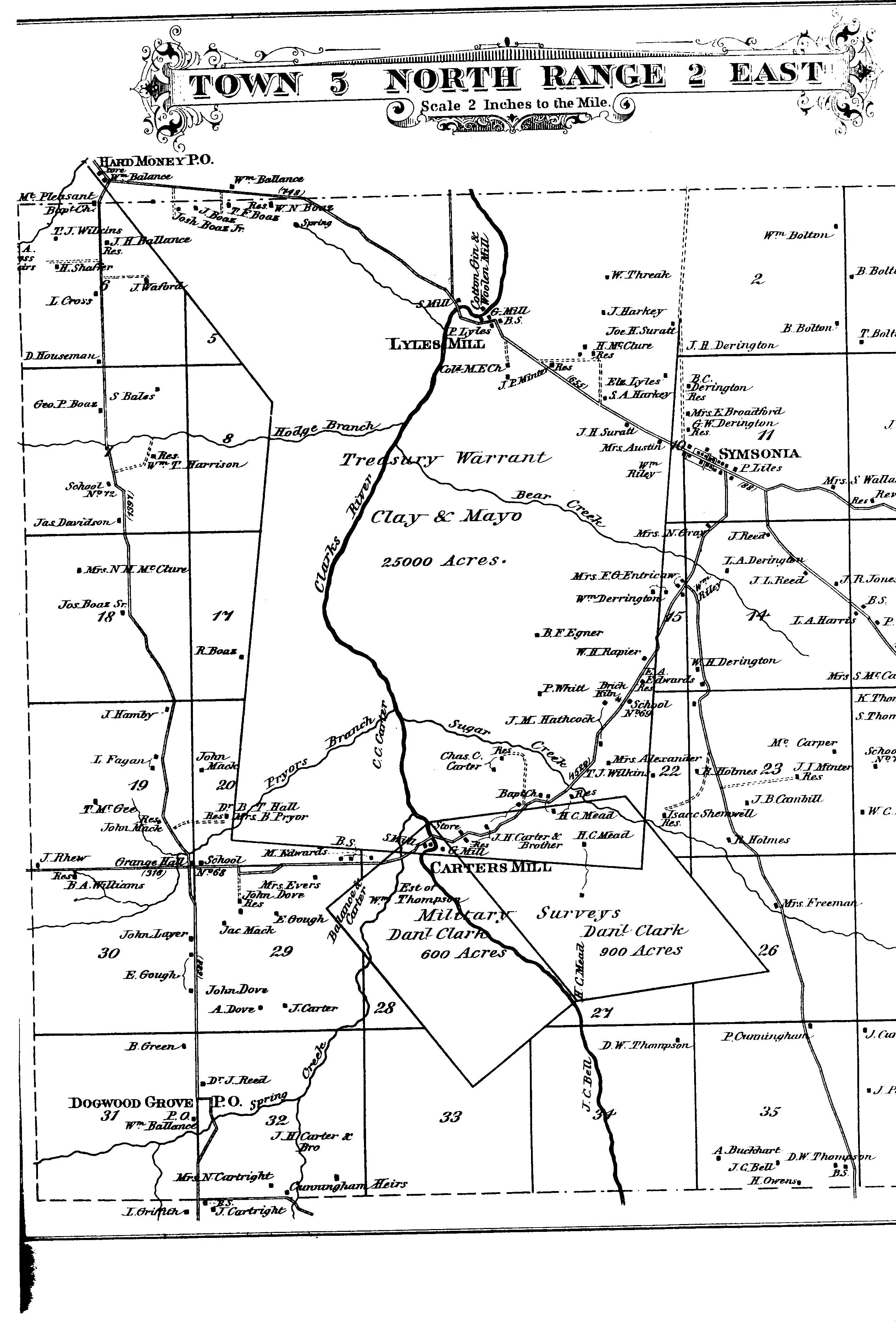
To view the east half of the Township, click HERE
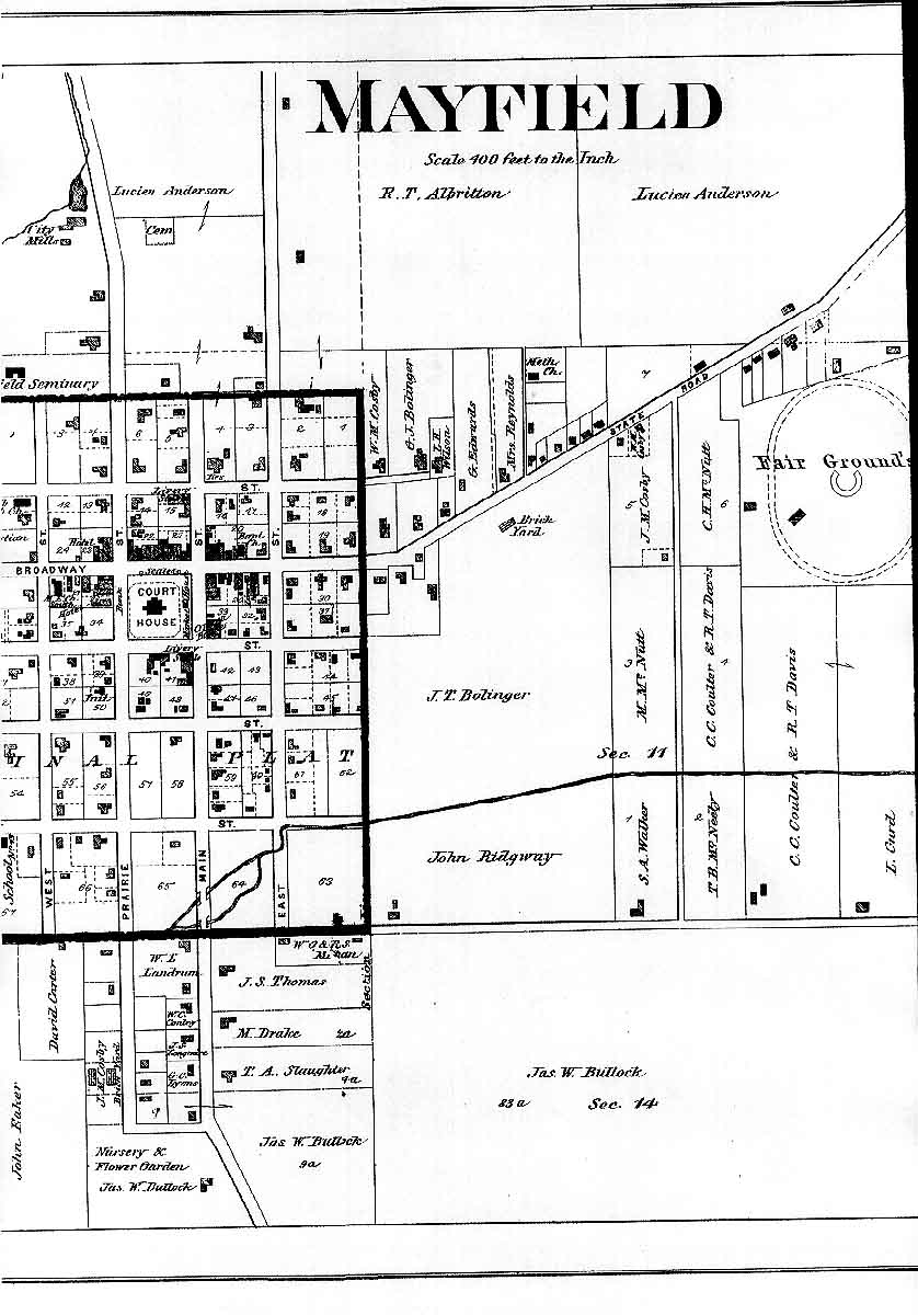
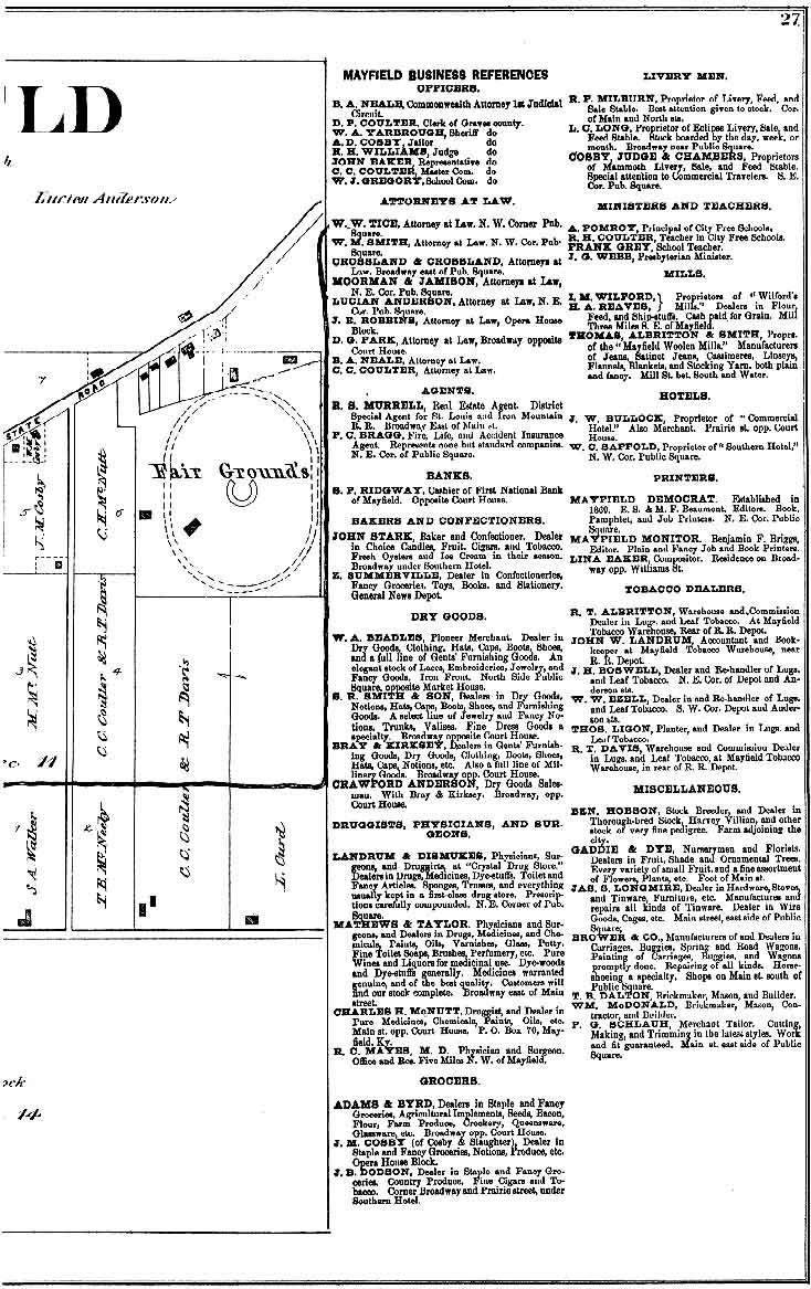
To view a map of the Town of Mayfield in Graves County, as depicted in the 1880 Graves County Atlas (with many landowners shown and a "Business Reference" section giving names of many businessmen in Mayfield), select one of the following: To view the western one-third of the town, click HERE
To view the central one-third of the town, click HERE
To view the eastern one third of the town and the Business Reference Section, click HERE
To view an image of Township 6, Range 2 West (parts of Ballard and McCracken counties), with original grantees names shown on each quarter section of land granted, click Here
To view an image of Marshall County with the rectangular survey township and range grid overlay, click HERE
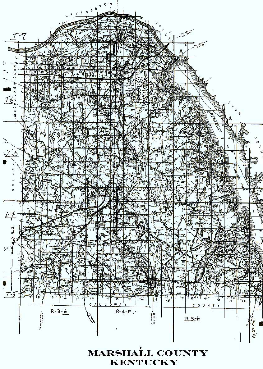
To view an image of a plat map of the town of Wadesboro, the first county seat of Calloway County, click HERE
To view an image of the plat map of Calloway Town, which was established in 1838(and disappeared by 1865) in what is now the northeast part of Calloway County, and located on the Tennessee River, providing ferry service across that River, click HERE
To view an image of the west-northwest part of Calloway County, with cemetery locations marked and numbered (with identifying name key on right side of image, as compiled by John B. Cavitt), click HERE
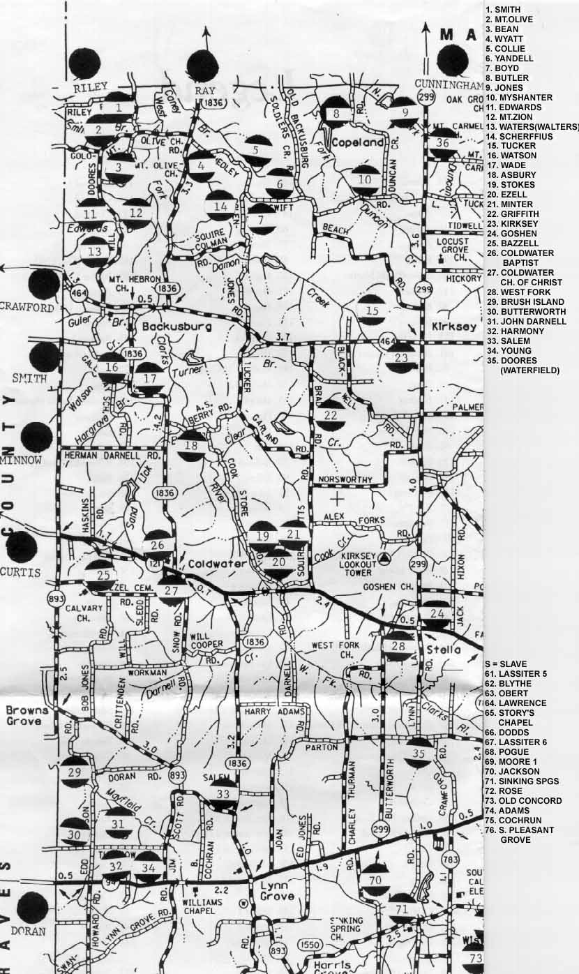
To view an image of the north-northwest part of Calloway County, with cemetery locations marked and numbered (with identifying legend), as compiled by John B. Cavitt, and courtesy of Carl Greenfield, click HERE To view an image of the west-southwest part of Calloway County, with cemetery locations marked and numbered (with identifying Legend, as compiled by John B. Cavitt), click HERE To view an image of the north-northeast part of Calloway County, with cemetery locations marked and numbered, click HERE To view the identification page, which gives the names of the cemeteries which correspond to the numbers on the N-NE area map, as compiled by John B. Cavitt, click HERE To view an image of the east-northeast-east central part of Calloway County, with cemetery locations marked and numbered, with identifications at the top of the image, as compiled by John B. Cavitt, click HERE
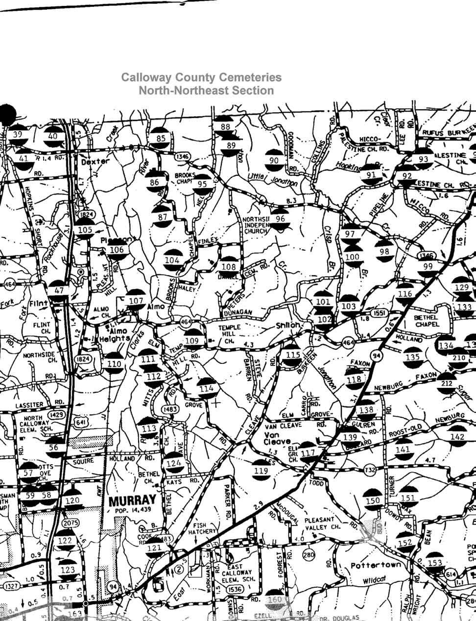
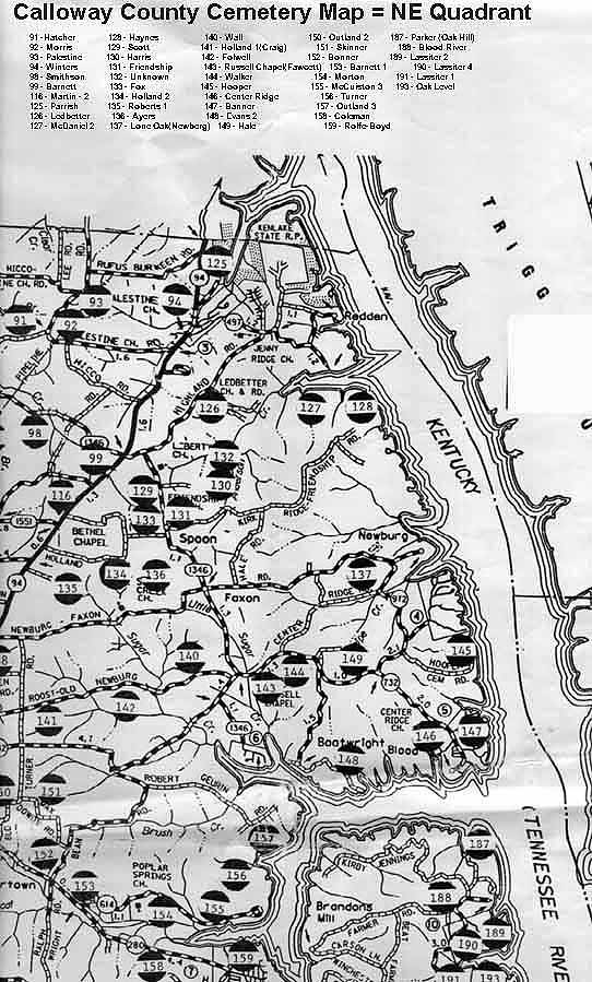
To view an image of the south-southeast part of Calloway County, with cemetery locations marked and numbered, with identifications on the right side of the image, as compiled by John B. Cavitt, with image furnished courtesy of Carl Greenfield, click HERE
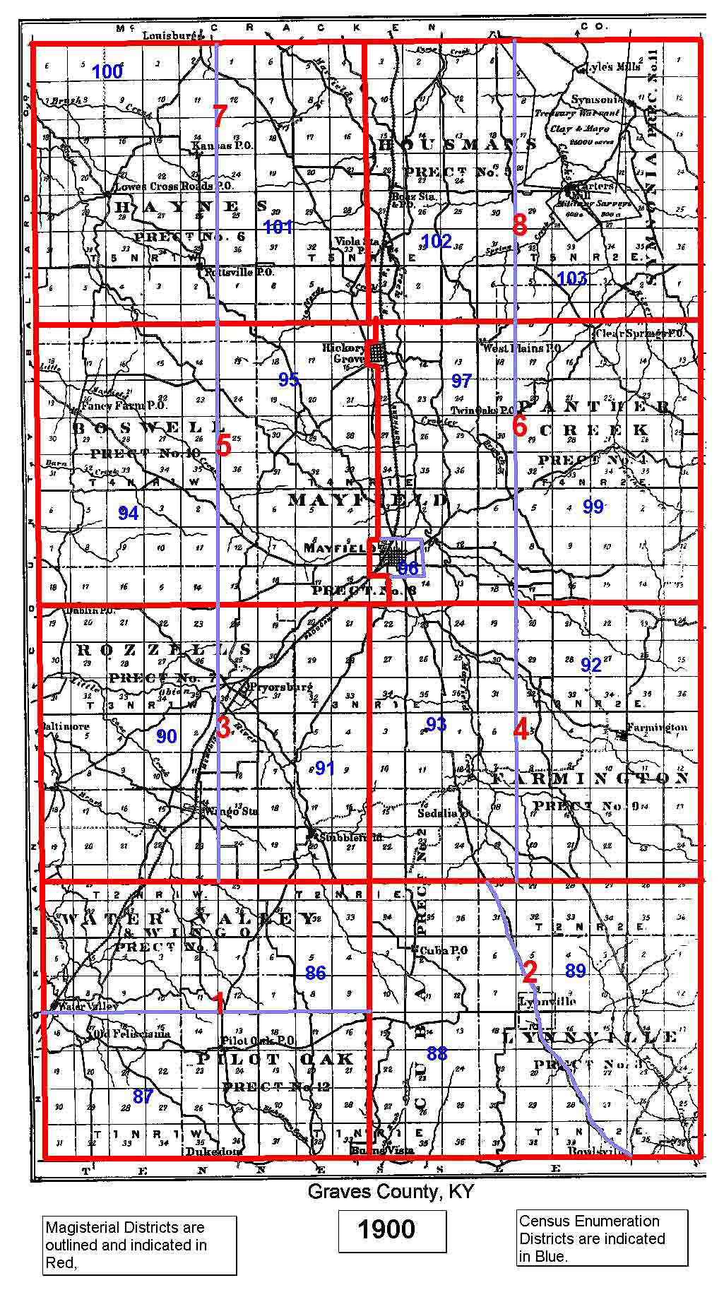
To view an image of a map of the 1900 Graves County Magisterial Districts and Census Enumeration Districts, courtesy of Garry Brown click HERE
USGenWeb Links


Neighboring Counties
- Calloway Co., KY
- Carlisle Co., KY
- Fulton Co., KY
- Hickman Co., KY
- Marshall Co., KY
- McCracken Co., KY
- Henry Co., TN
- Obion Co., TN
- Weakley Co., TN
Graves Co. Court Clerk
County Courthouse
Mayfield, KY 42066
Telephone:
(270) 247-1676