Muhlenberg County Kentucky
Local History: F
Federal Writers Project: Highway 62 from Elizabethtown to Paducah
Elizabethtown
US 62 turns (R) at the courthouse in Elizabethtown, 0 m., and runs southwest through the Knobs.
Clarkson
Clarkson, 25.9 m. (356 pop.), is at the junction with State 88.
Left from Clarkson on State 88 to Grayson Springs, 2 m., a collection of numerous white sulphur springs that vary in temperature.
Leitchfield
Leitchfield, 30.4 m. (635 alt., 950 pop.), was named for Maj. David Leitch, who owned the land on which this county seat was settled. Leitch's land was adjacent to a 5,000-acre tract claimed by George Washington.
West of Leitchfield the land is much dissected by the tributaries of Rough and Nolin Rivers, the most crooked waterways in the State. The general course of the highway is over the watershed between these two streams. Along the roadside are coal mine workings.
At 66.3 m. is the junction with State 71.
Right on State 71 to Hartford, 4 m. (425 alt. 1,106 pop.), seat of Ohio county, on the bank of Rough River, surrounded by hills that rise 650 to 700 feet. At the time of its founding in 1790, Hartford was called Deer Crossing, from which “hart-ford” was evolved. The Commerical Hotel in Hartford, established in 1797, was first known as the Lyon Inn.
Beaver Dam
Beaver Dam, 67.2 m. (1,036 pop.), is an important mining center of the western Kentucky coal fields. Excellent strawberries are grown in this region, and in early June at the close of the picking season Beaver Dam is the scene of an annual strawberry festival.
A ferry (toll $0.50) crosses the Green River at 77 m. (good muskellunge fishing), the narrowest stream in the State that can be navigated for any distance by steamboats; six locks and dams provide a constant five-foot channel. Its stillness, deep color, and closely overhanging trees produce a peaceful effect. It is believed that Green River was once a subterranean stream, and that through the ages the ceiling above wore away and caved in, bringing the stream to the surface. In this region have been found numerous shell mounds of a type exceedingly rare in Kentucky.
At 77.4 m. is the junction with Paradise Rd., unimproved.
Left on this road to the Site of Airdrie, 4 m., a ghost town. On the narrow strip of land between Green River and the hill upon which Airdrie was built, is a vine-covered furnace stack among the cedars and sycamores. More than 50 feet in height, the stone stack has a cylindrical section on a square base. Near by is the old fortlike, three-story machinery house of dressed sandstone, now without floors, roof, or window frames. On the wall is a stone bearing the legend, “Airdrie, 1855.” Shaded by trees and covered with Virginia creeper are 60 stone steps on the Site of the Alexander House, destroyed by fire in 1907.
Robert Alexander, founder of Airdrie, was born in Frankfort in 1819. He was educated in Scotland and, upon the death of his uncle, Sir William Alexander, succeeded him to the title. Several years later Alexander came back to Kentucky and bought about 17,000 acres of land along this section of Green River, where a deposit of ore had been discovered. Here he built an iron furnace, a mill, a large stone house, a hotel, and a number of houses for the iron workers that he had brought from Scotland. He called the place Airdrie, for his Scotch home. The venture was unprofitable, and, in 1857, Alexander abandoned the furnance and retired to his estate near Lexington.
In 1866 Gen. Don Carlos Buell bought 1,000 acres of land, including the Airdrie furnance, to prospect for oil. He found more coal and iron than oil, however, and began to work those deposits, But freight rates on Green River, his only outlet, were so high that he also abandoned the works. Buell lived here until his death in 1898.
West of the junction with Paradise Rd., US 62 continues through a comparatively desolate broken area, much dissected by the many small tributaries of Green River.
Central City
Central City, 85.6 m. (462 alt., 4,321 pop.), a mining town in a basin among the hills, has an air of industrialism because of the smoke and noise from its railroad yards. The community was long known as Morehead's Horse Mill, having been built on land once owned by C.S. Morehead, who operated a gristmill propelled by horse power. After the building of the Illinois Central R.R. in 1870, the named was changed.
At Central City is the junction with State 81.
Right on State 81, which passes through a region where large amounts of coal are produced. The ruins of many old furnaces are evidence that mining and the smelting of iron ore was formerly a flourishing industry here.
Bremen, 9 m. (255 pop.), is a community settled by German imigrants, who named it for the German seaport.
In 1861 Sacramento, 14 m. (327 pop.), was the scene of an engagement between Confederate troops under Col. Nathan B. Forrest, and a company of Federals under Capt. Robert G. Bacon. The Confederates were victorious.
Rumsey, 25 m. (392 alt., 262 pop.), mainly a residential village, is connected with Calhoun by the James Bethel Gresham Memorial bridge (toll $0.25), which spans Green River and was named in honor of one of the first three American soldiers to fall in the World War. Gresham, a corporal in the 16th Infantry, was killed at Batelmont, France, on November 3, 1917.
Calhoun, 26 m. (392 alt., 683 pop.), seat of McLean County, on the north bank of Green River, was known as Fort Vienna in 1788, when it was founded by Solomon Rhoades. A granite marker (L) commemorates the Site of Fort Vienna and indicates the hillside where the early settlers dug caves for refuge during Indian attacks.
John Calhoun, for whom the town was named, was the first circuit judge of old Fort Vienna, and United States Congressman for one term (1835-39).
Right 8 m. from Calhoun on State 138 to Livermore (1,573 pop.), on the north bank of Green River. Logs are rafted down to Livermore for use by two chair factories. The industry exists also on a home production basis, and new rattan-bottom chairs are displayed on porches and in the yards of many dwellings.
South of Central City, US 62 traverses a country of scrub timber, denuded hillsides, and areas heavily brush-grown. There are many small coal mines along the highway; one of them, now abandoned, is the Dovey Mine. To it in the summer of 1881 came a stranger, apparently in search of employment. He casually inquired as to when the railraod pay train was due in Central City, was informed that it had passed through the morning before, and that William Dovey, who had gone for the money, would return some time during the night. The next morning three strangers appeared at the Dovey store. Two of them stood outside as guards; the third, with cocked pistol, entered the building and demanded the contents of the safe. Their holdup was successful, but because William Dovey had been delayed in bringing back the pay-roll money, the loot was $13 in cash and a gold watch engraved with John Dovey's name. When Jesse James was killed a year later, the Dovey watch was among the things found in James' possession and was returned to its owner.
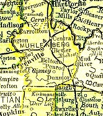
Greenville
Greenville, 93.1 m. (538 alt., 2,451 pop.), is the seat of Muhlenberg County, named for Gen. John Peter Gabriel Muhlenberg (1746-1807), a Lutheran minister of Virginia, who left his pulpit at the beginning of the Revolutionary War to become a military officer. Although General Muhlenberg made two trips to Kentucky in 1784, he never visited the section that bears his name. Greenville is the unofficial capital of the Black Belt, an area that produces a large quantity of coal and most of the State's output of dark tobacco. Substantial dwellings with wide verandas and spacious, shady lawns reflect the leisure of the retired farmers who live here.
The Weir House, 206 Main St., a two-story brick structure, built in the early 1840's, incorporates many Georgian Colonial features. Its entrance has an especially fine fanlight and side lights containing the greenish glass that was in common use when this house was built. The Henry C. Lewis House, a two-story Georgian Colonial style structure, was erected for the Presbyterian Academy in 1852 and used by it until 1873. In 1856 this school was placed under the supervision of Dr. James K. Patterson, who subsequently became president of the University of Kentucky. The Greenville school district now owns and uses the two large brick buildings that formerly housed Greenville College, a school that flourished from 1875 to 1890.
At 93.6 m. is the junction with State 107.
Left on this road to the Ruins of Buckner Furnace, 5 m., erected in 1837 by Aylette H. Buckner, father of Gen. Simon B. Buckner, to refine the surface iron ore of southern Muhlenberg County. A pile of dressed rock in a thicket is all that remains of the stack, which stood intact until 1907, when it was dynamited by people seeking the iron that remained in it. The stack, a conical tower 80 feet high, 40 feet wide at the base, and 25 feet across the top, had a double wall of sandstone, hooped with six iron bands. To the north of the stack were the cabins of Buckner's miners and wood choppers, but all traces of these have now disappeared.
The three large stone chimneys about 300 yards east of the stack are the ruins of the two-story log house used by Buckner as a residence, office, and store. It is said that it took three yoke of oxen to haul Buckner's private library from Glen Lily in Hart County to this place. Opposite the southern end of the house in the hillside was the stone milk house over a spring. The spring still flows from under the crumbling walls.
West of Greenville there is a gradual improvement in the quality of the farm lands and the character of farm buildings.
Pond River
On the bank of Pond River (R), 104.5 m., near the highway bridge, is a ledge of rock bearing the imprint of horses' hoofs. Sections of this rock have been taken to the St. Louis Museum.
Nortonville
Nortonville, 111.5 m. (429 alt., 829 pop.), a coal-mining community, is on the site (R) of a prehistoric village from which many artifacts have been recovered. These have been widely scattered, but good specimens are preserved in the museum of the University of Kentucky.
Nortonville is at the junction with US 41.
Dawson Springs
Dawson Springs, 125.7 m (436 alt., 2,311 pop.), on the western edge of the coal fields, has noted mineral springs and resort hotels. At the southern edge of Dawson Springs is a fine view of the meandering Tradewater River.
Left from Dawson Springs on State 109 to Dawson Springs State Park, 3 m. This 500-acre tract, which has been reforested, includes a custodian's lodge, water system, trails, bridges, shelter houses, picnic areas, and improved roads.
In Outwood, 4 m., is the United States Veterans Hospital (open daily 9-4), in a densely wooded reservation of 5,000 acres. The 27 modern buildings, chiefly of brick, stone trimmed, occupy a landscaped plot of about 20 acres. These were erected at a cost of approximately $2,250,000. Reforestation and the reclamation of eroded tracts has been carried on.
West of Dawson Springs US 62 crosses the Tradewater River.
Princeton
Princeton, 137.8 m. (484 alt., 4,764 pop.), an industrial and retail center and the seat of Caldwell County, is widely known for its beautiful tree-shaded streets and well-kept homes. Fluor-spar mining is carried on in the vicinity. Underneath the town flows a subterranean stream that is the town's water supply. At Big Spring Bottoms, two blocks from the courthouse, the stream comes to the surface, and here the first settlers built their rude log cabins.
On county court day, held the third Monday of each month, the streets are filled with count folk visiting and trading. A farmer was once heard to remark that in “his best trading days” he had often taken a horse or mule to Jocket Street, “swapped around a spell,” and at evening had gone home with the same animal and $100.
West of Princeton, tobacco fields dominate a countryside in which are some coal mines and old workings.
The old Flournoy House (R), 138.1 m., a two-story frame dwelling of eight or nine rooms, has been unoccupied for nearly 20 years, but is kept in excellent condition. It was built early in the nineteenth century by the first of the Flournoys to settle here. Though weird stories of ghosts in the house began to circulate in 1890, the site and the splendid construction of the building attracted buyers who scoffed at “hants” but never remained long. Several groups of the most skeptical persons in the community each determinedly spent a night in the house but never cared to repeat the experience. Some asserted that they had heard the rattling of chains and soft footfalls that approached and passed; others insisted that they had heard the slow music of a funeral march. Verses were written in blue crayon on the walls by unseen hands. The verses were always about battles of the War between the States, the Spanish-American War, and the assassination of Gov. William Goebel. During the gubernatorial election of 1899, William Goebel, Democractic contestant, had been shot by an assassin whose identity was never learned. Among the doggerel that appeared on the walls was:
Remember the Maine
Goebel the same,
A humble man of moral ways,
Lies murdered in his greatest days.
As long as they stand these walls proclaim
The glory of his shining name.
Who disturbs these lines shall find
The bounty of this curse in rhyme…
Chains shall bind theee, bats shall tear
Out your eyes, nest in your hair:
Oh guard thee well these thoughts of mine,
Ye haunts that lived in Goebel's time.
Eddyville
Eddyville, 150.7 m. (436 alt., 1,990 pop.), seat of Lyon County, on the bank of the Cumberland River, was so named because of eddies in the river above and below the city.
The State Penitentiary [visited by application 9-3 daily), often referred to by prisoners as the Castle on the Cumberland, has a grim, feudal appearance accentuated by the central entrance twoer and the stone wall that encloses 12 of the 37 acres in the prion tract. The old stone structure received its first prisoners in 1885. Since then several wings have been added, including two cell blocks, a mess hall, and in 1938 a recreational center. Between 1911 to 1935, 84 prisoners were electrocuted here. In May 1938 the prison held 1,473 convicts.
Kuttawa
Kuttawa, 153.4 m. (436 alt., 833 pop.), is chiefly rememberd for the beautiful trees that border the highway.
Right from Kuttawa on State 93 to the ruins of Kelly's Iron Furnace, 1 m., where William Kelly (1811-88) invented the air-boiling process, later known as the Bessemer process of making steel. Kelly was born in Pennsylvania and about 1846 settled in Eddyville where he engaged in the iron business; here he accidentally discovered the revolutionary process of converting pig and cast iron into steel, but because of the insufficient blast pressure he was only partly successful in making steel. From 1851 to 1856 he built experimental converters and worked secretly; through his tests he learned that when an air blast blew directly on the molton iron a greater heat was produced as a result of the more rapid decarbonization of the cast iron. Although his family and friends feared he was losing his mind, and attempted to persuade him to abandon his work, two Englishmen, whom Kelly had hired to assist in the experiments, greatly encouraged him. He therefore concealed nothing from them. When both Englishmen, who were familiar with his processes, disappeared one night, Kelly traced them to Pennsylvania, then to New York, where he learned that they had taken passage to England. In 1856 Sir Henry Bessemer of England was granted a United States patent on the perfected process. Upon hearing this, Kelly also applied for a patent and convinced patent officials of the priority of his process. On June 23, 1857, he was granted the patent and declared the original inventor. Fourteen years later Kelly's patent was renewed for seven years, while Bessemer was refused a renewal.
The contest between Kelly and Bessemer was settled by the formation of a corporation that united an ironworks company near Detroit, which manufactured iron under Kelly's process, with another in Troy, New York, which used Bessemer's patents. Kelly retired soon afterward, and only Bessemer's name became identified with the process.
Kuttawa Mineral Springs Park (amusement charges $0.05 to $0.25), 2 m., is a well-shaded tract of 165 acres. Kuttawa' seven springs produce crystal-clear tasteless mineral water. Within the park are a hotel, cafe, cabins, open-air auditorium, tennis courts, ballground, and a swimming pool that is supplied with water from the spring at the rate of 150,00 gallons a day. A D.A.R. monument near the hotel commemorates Cobb's Battery, an artillery organziation prominent in the War between the States.
Iuka
At Iuka, 160.0 m. (381 alt., 55 pop.), US 62 crosses the Cumberland River by ferry (toll $0.50) and passes through the narrow hilly strip of land that forms a watershed between the Cumberland and Ohio Rivers. Here tobanno and corn are the chief products.
Smithland
Between Smithland, 172.8 m. (286 alt., 519 pop.), and Paducah, US 62 and US 60 are one route.
Paducah
Paducah, 188.9 m. (341 alt., 33,541 pop.).
Points of Interest: Paduke Statue, Tilghman Memorial, Irvin Cobb Hotel, McCracken County Courthouse, Noble Park, Marine Ways, Brazelton House, Illinois Central House.
Paducah is at the junction with US 60, US 68, and US 45.
Source: Federal Writers' Project. “Tour 14.” Kentucky: A Guide to the Bluegrass State. Work Projects Administration for the State of Kentucky. Sponsored by the University of Kentucky. New York: Harcourt, Brace & Company, 1942, pp. 356-362.
Updated July 14, 2022