Gains, Daniel
28 July 1786
9,300 acres
NW corner of William Booth's 16,000 acres, on the West fork of Lulbegrud(?) course and upper Howards creek
Gains, Daniel
26 Jan 1783
9,300 acres
On the waters of Lulbregrud course, south of William Booth's 16,000 acre survey.
Gains, Daniel
8.800 acres
26 Mar 1787
(Survey for entry made 26 Jan 1783 for 9,300 acres - see above)
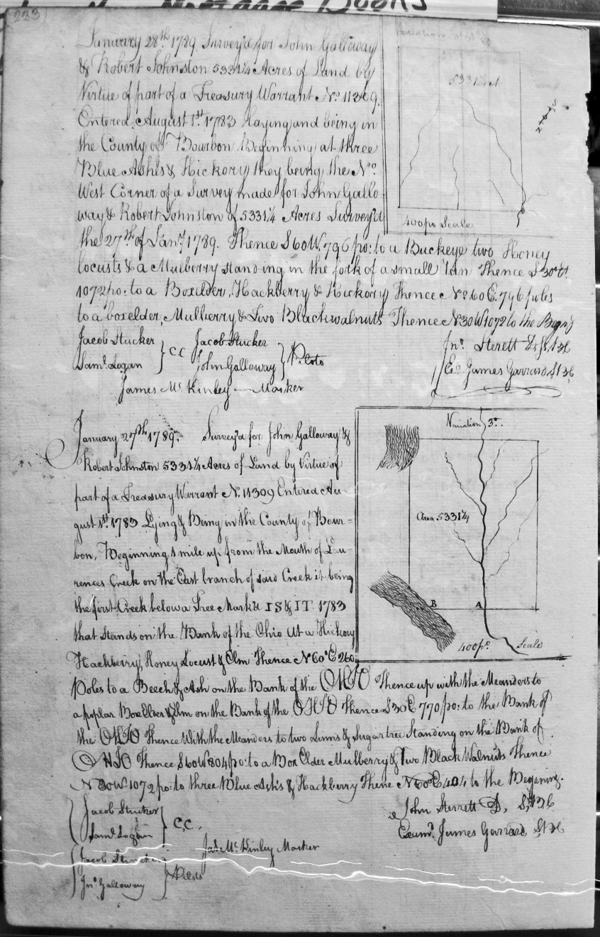
Galloway, John, and Robert Johnston
28 Jan 1789
5,531 1/4 acres
On the NW corner of John Galloway and Robert Johnston's 5,331 1/4 acres surveyed 27 Jan 1789 and the fork of a small run.
Galloway, John, and Robert Johnston
27 Jan 1789
5,531 1/4 acres
A mile from the mouth of Laurence's creek on the East branch of said creek, it being the first creek below a tree marker IS& IT 1783 that stands on the bank of the Ohio, then to another bank of the Ohio and with its meanders.
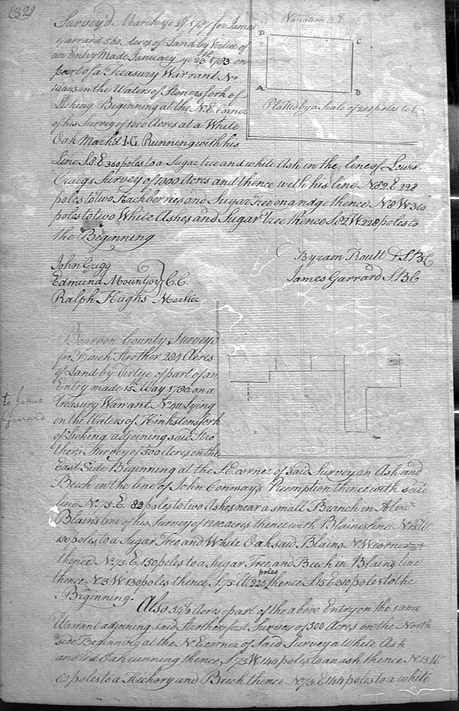
Garrard, James
29 March 1787
500 acres
On the waters of Stoners fork of Licking, on his 1,000 acres survey and Lewis Craig's 1,000 acre survey.
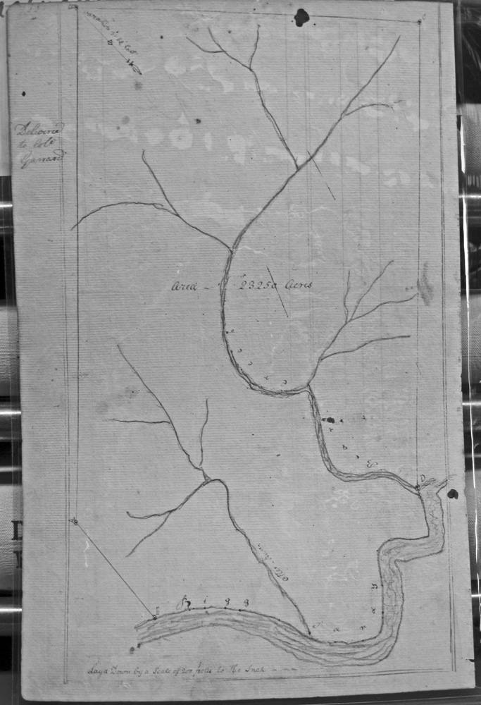
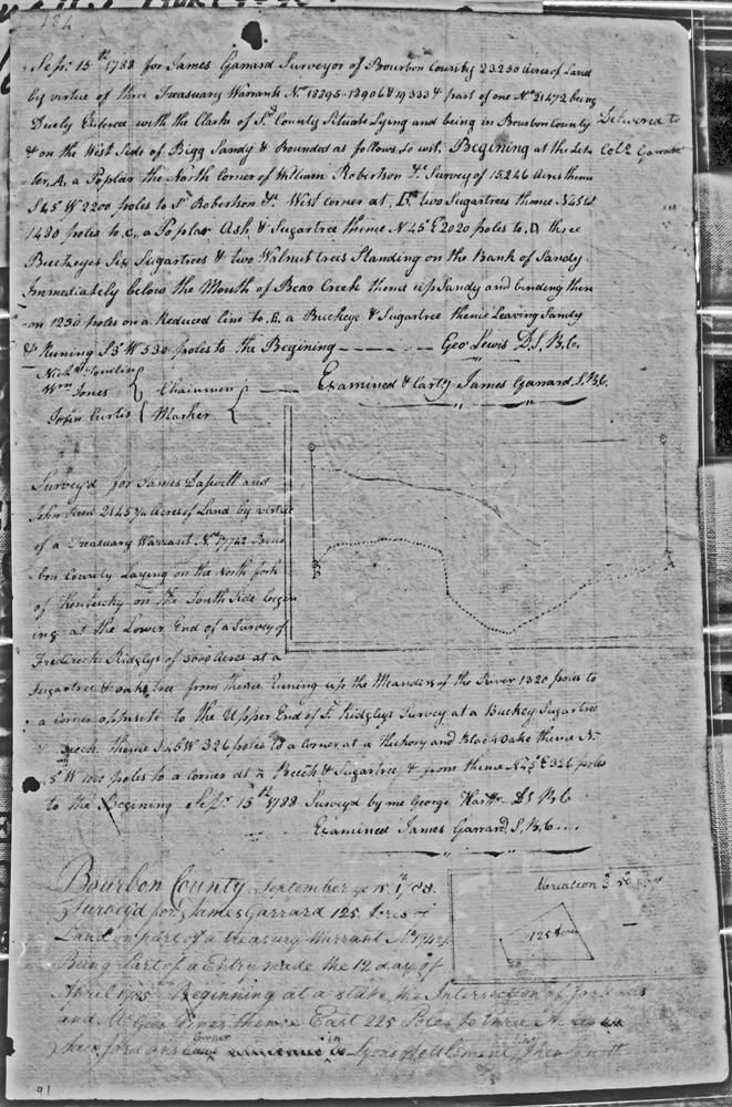
Garrard, James, surveyor
15 Sept 1788
23,250 acres
3 entries on the West side of Bigg Sandy, and bounded by the survey of William Robertson for 15,246 acres, and on the bank of Sandy immediately below the mouth of Bear Creek.
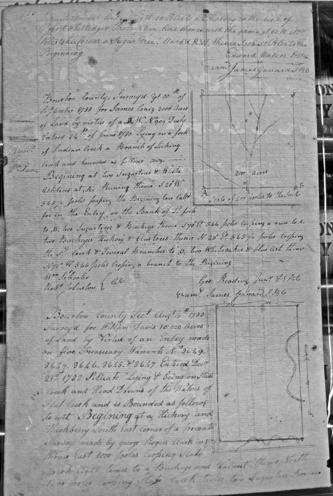
Garrard, James
15 Sept 1788
125 acres
On the intersection of Jordan's and McGee's lines, Hines' line, Lyon's settlement line and on Robert Whitledge's Preemption line.
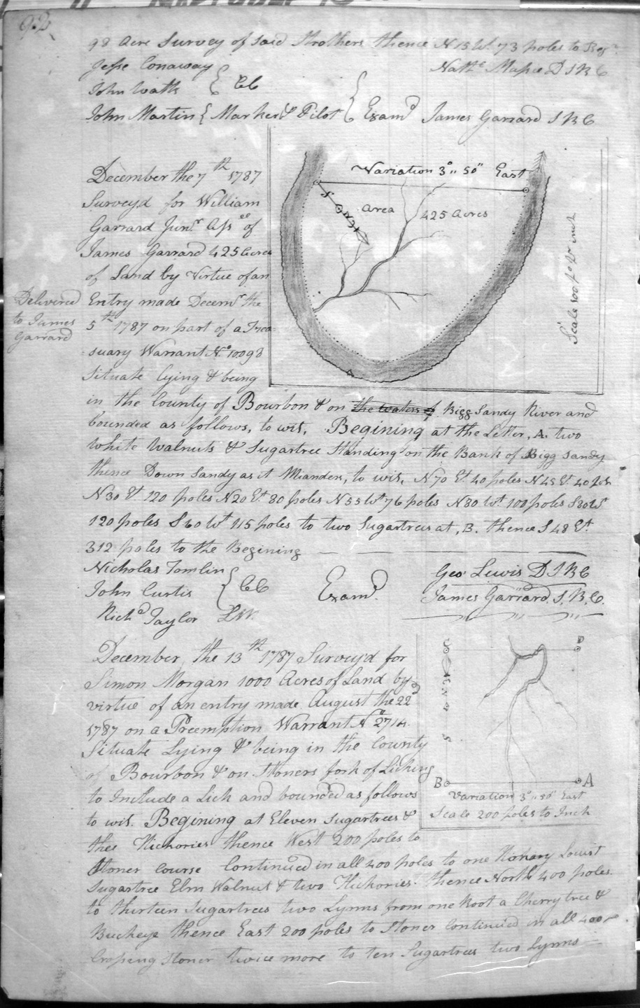
Garrard, William Jr.
7 Dec 1787
425 acres
On the Bigg Sandy River and down its meanders.
Garrard, William
27 Apr 1789
2,958 1/4 acres
On the Waters of Bigg Sandy and bounded by the NE corner of Sd. Garrard's Survey of 2,958 1/4 acres as part of this entry.
Garrard, William
27 Apr 1789
2,958 1/4 acres
On the Waters of Bigg Sandy and bounded by Isaac Lewis's survey of 2,500 acres in the line of George Lewis's survey of 19,050 acres.
Gillaspie, David
29 May 1787
1,500 acres
On thes lines of Thomas Broches's 2,731 acre survey, crossing Fork creek course and on a branch of Hinksons
Gilpin, Israel
27 Apr 1789
132 acres
On the South fork of Licking, and bounded by the NE corner of the Preemption of John Layson, and the Preemptions of Samuel Lyons and Reed.
Gilpin, Israel
27 Apr 1789
96 acres
On the waters of Hustons fork of Licking, and bounded by the Preemptions of Samuel Lyons and Reed.
Gode, Marke
22 Aug 1787
2,095 1/4 acres
On the waters of Sandy and Tygart's creek, and on the SW corner of Charles Burton's 3,000 acre survey
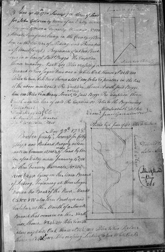
Goldson, John
750 acres
On the waters of Licking, on the line of Robert Boggs' Preemption.
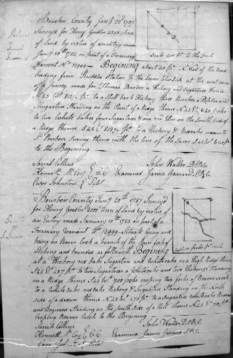
Goodloe, Henry
22 Jan 1787
3,250 acres
On the lines of the Road leading from Ruddles Station to the Lower blue Licks and Thomas Barber's survey,
Goodloe, Henry
20 Jan 1787
2,000 acres
On the waters of Beaver Creek.
Grant, John
18 Feb 1787
400 acres
On Houston's fork a Branch of Licking adjoining his Preemption of 600 acres below
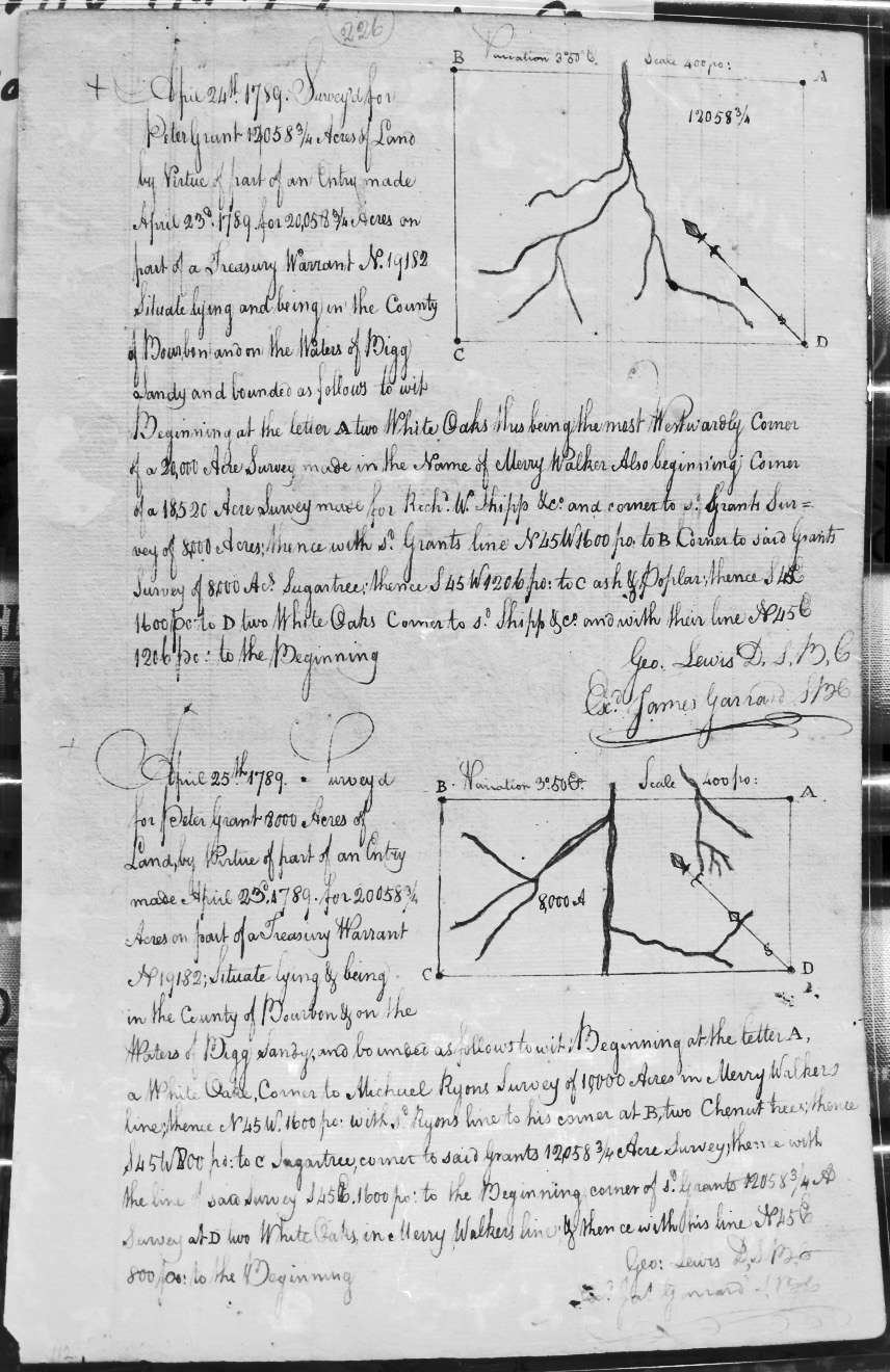
Grant, Peter
24 Apr 1789
12,058 3/4 acres
On the waters of Bigg Sandy, on the most westerly most corner of Merry Walker's 20,000 acre survey and the Richard W. Shipp, & Co., 18520 acre survey, and sd. Grant's 8,000 acre survey.
Grant, Peter
25 Apr 1785
8,000 acres
On the waters of Bigg Sandy, on the lines of Michael Ryan's 10,000 acre survey on Merry Walker's line and sd. Grant's 12,058 3/4 acre survey.
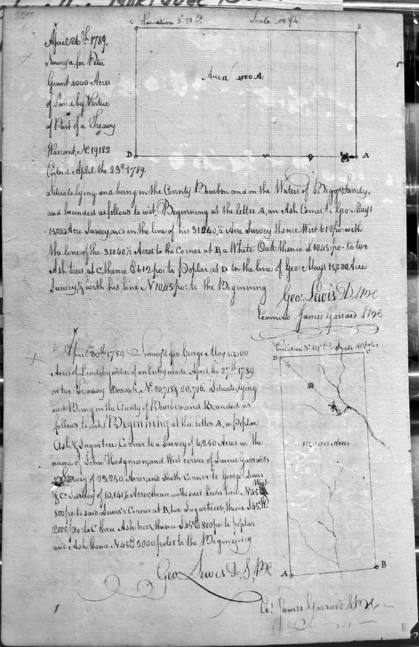
Grant, Peter
26 Apr 1789
4,000 acres
On the waters of Bigg Sandy, on the lines of George May's 15,000 acre survey and his (May's ?) 31,040 1/2 acre survey.
Grason, Hon'l William
27 Apr 1789
6,000 acres
On the N. corner of Michael Ryan's 10,000 acre survey on the waters of Bigg Sandy.
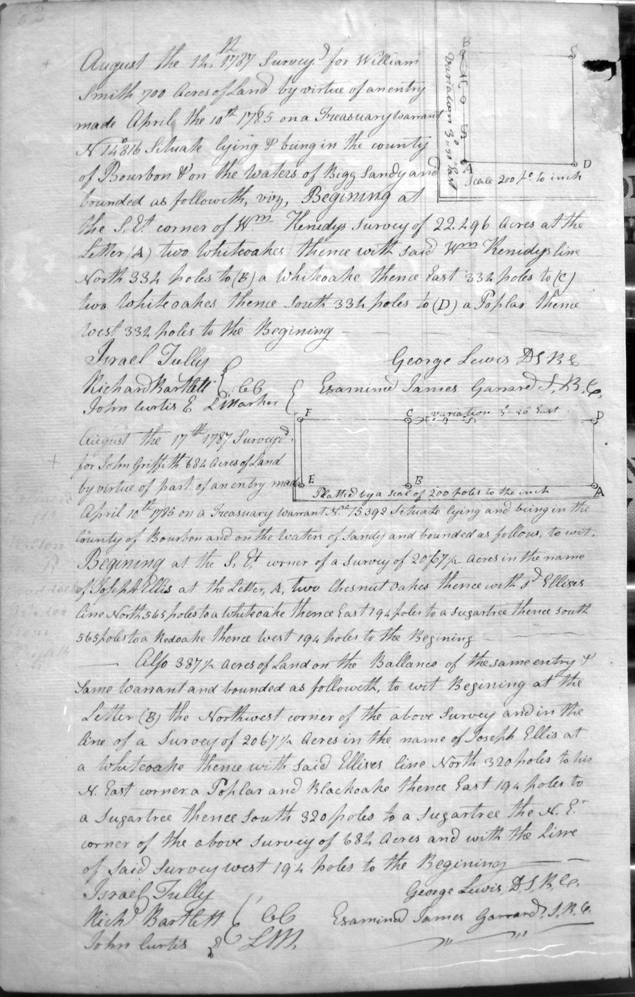
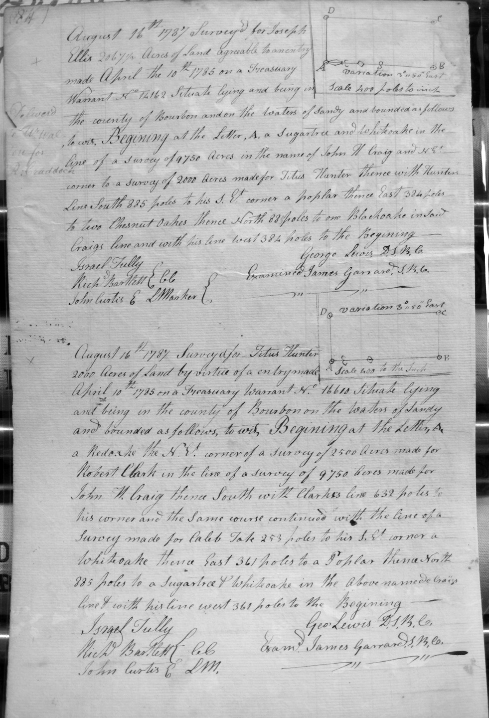
Griffith, John
17 Aug 1787
1,071 1/2 acres
684 acres
On the waters of Bigg Sandy and on the SE corner of Joseph Ellis's 2,067 1/2 acre survey; also 387 1/2 acres, the balance of the same survey, on the NW corner of Ellis's survey and with the line of the 684 acres.
Guiltner, Barnard, Assignee
12 Mar 1790
40 (?) acres
Too faint to read.
Guiltner, Barnard, Assignee of Jacob Myres
12 Mar 1790
50 acres
Too faint to read.
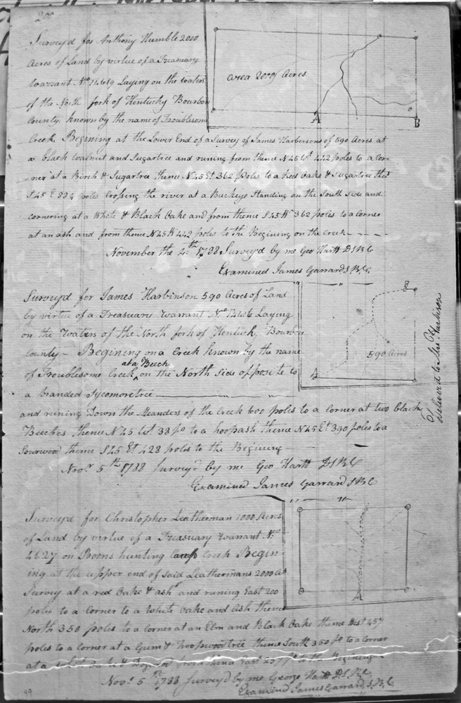
Harbinson, James
5 Nov 1788
590 acres
On the waters of the North fork of Kentucky, on the line of Troublesome creek, on the north side opposite to a branded sycamore tree.
Harding, Enos
24 Sept 1789
1,000 acres
On the headwaters of the Main Fork of Stoners fork of Licking about five miles above the survey of Douglas on sd. creek, and to include his improvement.
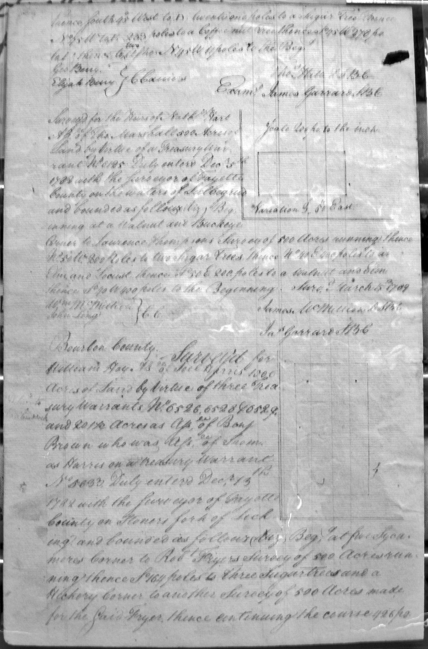
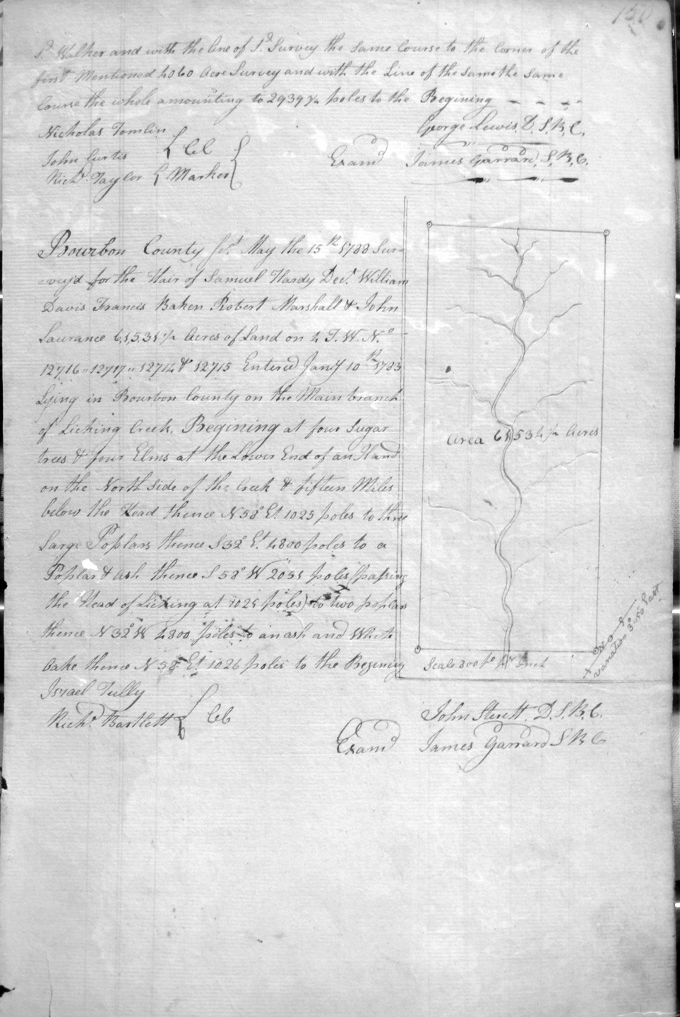
Hardy, Samuel, dec'd. Heirs, William Davis, Francis Baker, Robert Marshall & John Laurance
15 May 1788
61,531 1/2 acres
On the Main branch of Licking, at the lower end of a hand on the North side of the creek, and fifteen miles below the head.
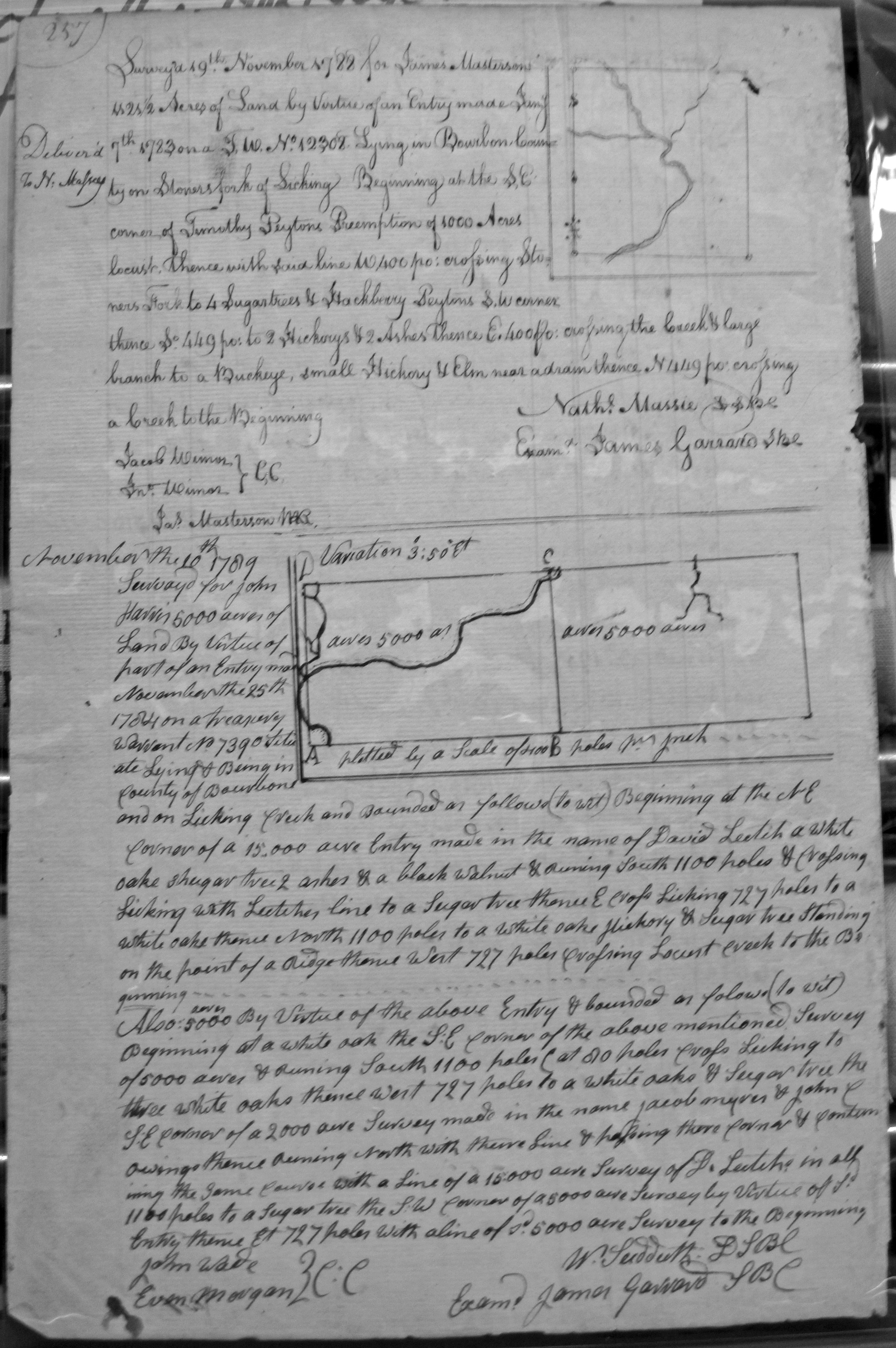
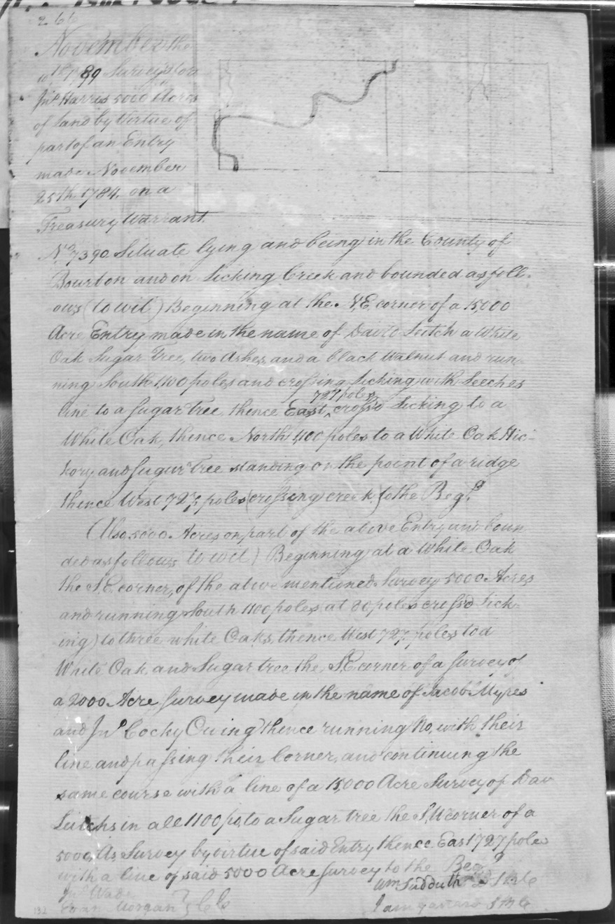
Harris, John
10 Nov 1789
5,000 acres On Licking Creek, and bounded by the NE corner of a 15,000 acre survey of David Leitch, crossing Licking with Leetch's line, and eventually crossing Locust creek to the beginning.
And, also:
3,000 acres On the SE corner of the above mentioned survey of 5,000 acres, crossing Licking to a 2,000 acre survey in the name of Jacob Myres and John C. Owings, and then going with their line and crossing the corner of the same course with a line of the 15,000 acre survey and two 5,000 acre surveys.
Harris, Jno.
10 Nov 1789
5,000 acres On Licking Creek and bounded by the NE corner of a 15,000 acre survey in the name of David Leitch, following Leech's line and crossing Licking with his line, recrossing the creek twice.
And, also:
5,000 acres On the above entry and bounded by the SE corner of the above survey, and SE corner of a 2,000 acre survey made in the name of Jacob Myres and John Cocky Owing, and a 15,000 acre survey of David Leitch.
Harris, William
6 Nov 1788
534 acres
On the waters of North fork of Kentucky, known by the name of Buckhorn Creek, at the lower end of Robert Buckner's 4,000 acre survey.
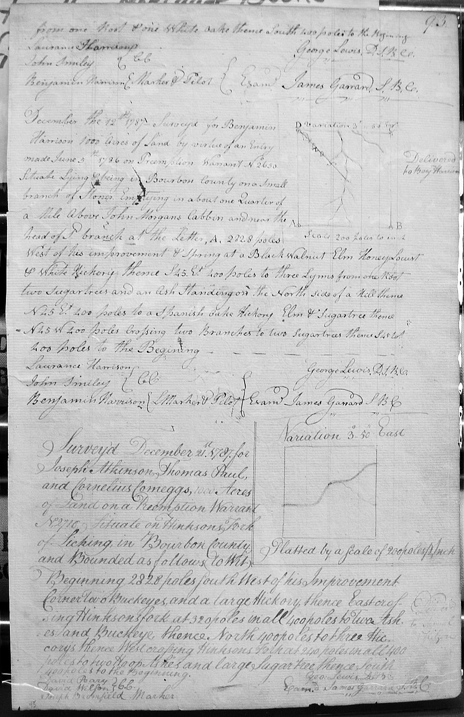
Harrison, Benjamin
12 Dec 1787
1,000 acres
On a small branch of Stoner's, emptying in about a Quarter of a mile above John Morgan's cabbin and near the head of said branch West of his improvement and Spring.
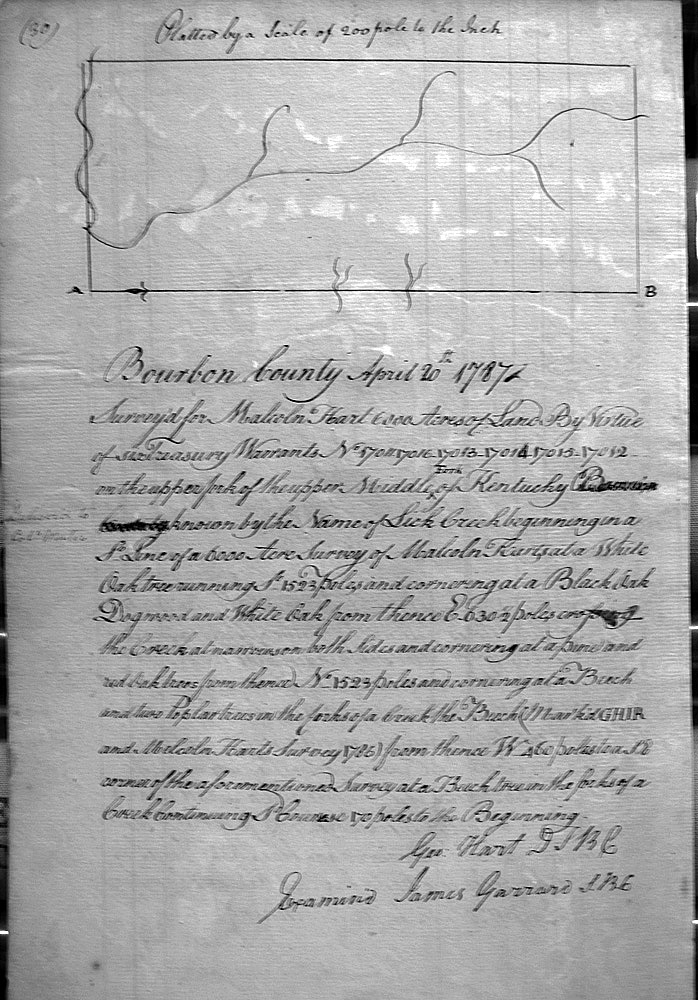
Hart, Malcoln
21 Apr 1787
6,000 acres
On the upper 3 forks of the upper North fork of Kentucky River, known by the name of Lick Creek on the line of Hart's 8,000 acre survey
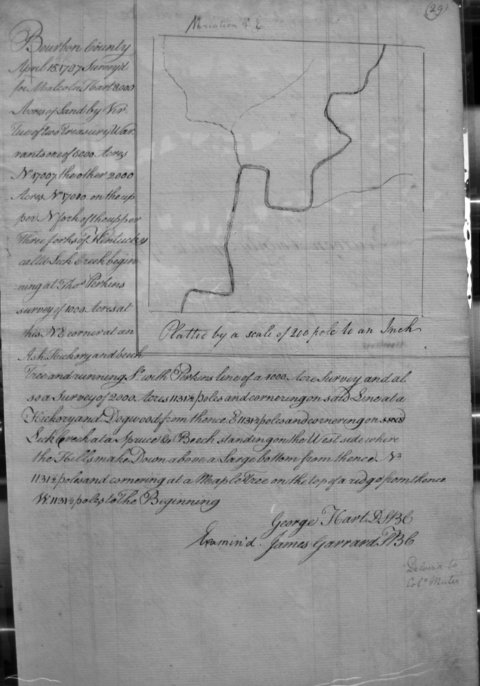
Hart, Malcoln
15 Apr 1787
8,000 acres
On the upper North Fork of the upper 3 forks of the upper North fork of Kentucky River, called Lick Creek on the line of Tho's Perkins 1,000 and 2,000 acre surveys.
Hart, Malcoln
20 Apr 1787
8,000 (?) acres
In the upper fork of the upper middle fork of the Kentucky on the lines of Hart's 6,000 acre survey.
Hart, Nathaniel, Heirs
16 Feb 1789
1,000 acres
Entered with the surveyor of Fayette County adjoining Edward Williams preemption on Lulbegrud, and bounded by said preemption, corner to Nick's Andersons preemption, and with his lines back to Williams lines.
Hart, Nathaniel, Heirs, Assignee of Tho. Marshall
15 Mar 1789
500 acres
On the waters of Lulbegrud, and bounded by Lawrence Thompsons survey of 500 acres, Entered with the surveyor of Fayette County adjoining Edward Williams preemption on Lulbegrud, and bounded by said preemption, corner to Nick's Andersons preemption, and with his lines back to Williams lines.
Hart, Thomas
15 Mar 1789
500 acres
Entered with the surveyor of Fayette County on the waters of Lulbegrud, and bounded by the survey of 500 acres made for Nathaniel Hart's heirs.
Hart, Thomas
19 Mar 1789
1,500 acres
Entered with the surveyor of Fayette County adjoining his former survey of 500 acres on the dividing ridge between Stoners fork of Licking and Howards creek, and bounded by the most northwardly corner of said Harts former survey of 500 acres.
Hart, Thomas
17 Mar 1789
500 acres
Entered with the surveyor of Fayette County on the dividing ridge between Stoners fork of Licking and Howards creek.
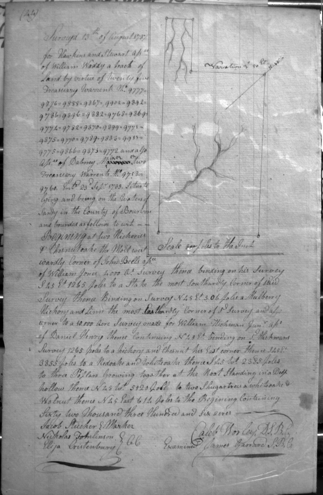
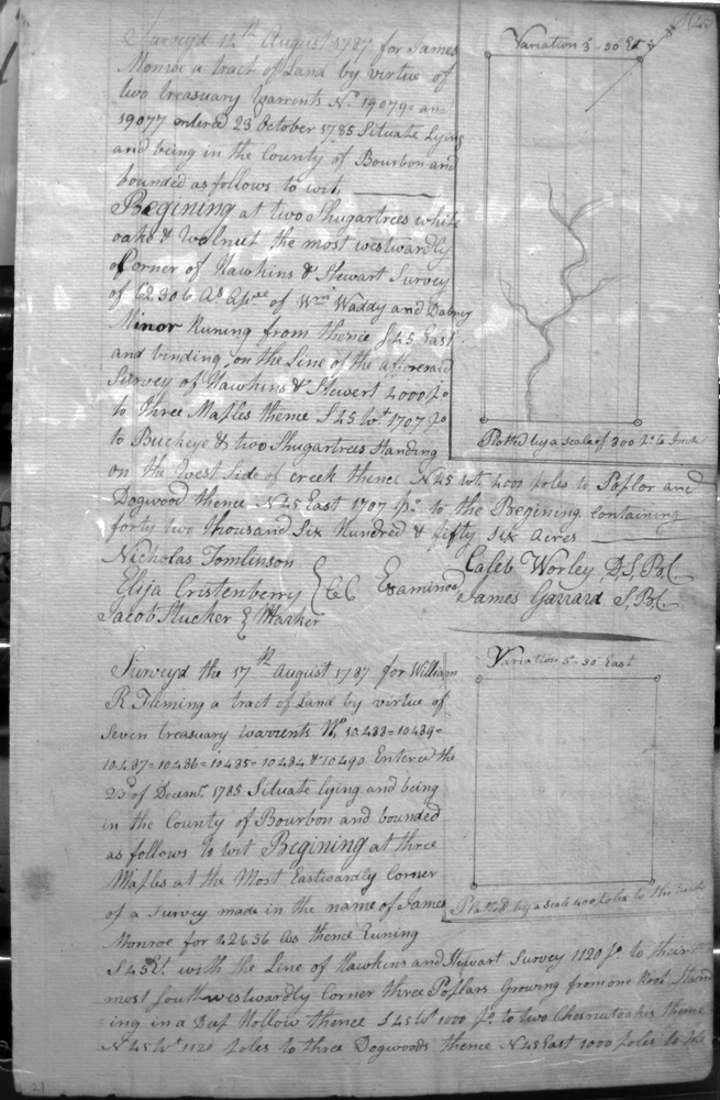
Hawkins & Stewart Assignees of William Waddy & Dabney Minor
13 Aug 1787
62,306 acres
On the waters of Sandy on lines of John Bell Assignee of William Jones 2,000 acre survey and William Hickman Assignee of Daniel Henry 10,000 acre survey
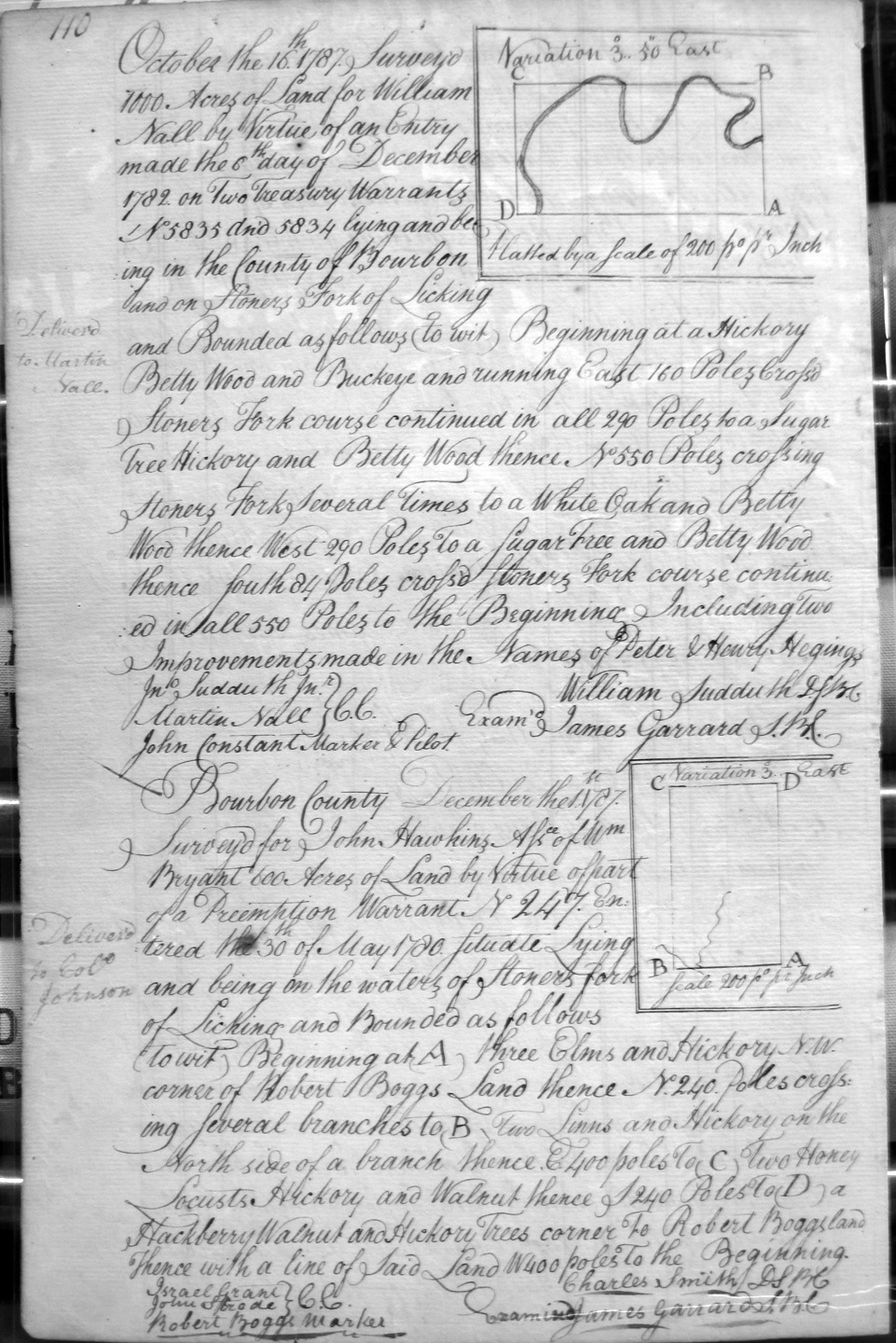
Hawkins, John, Assignee of Wm. Bryant
1 Dec 1787
600 acres
On the waters of Stoner's Fork of Licking and on the NW corner of Robert Bogg's land.
Hay, William, Assignee of John Harris
5 Mar 1789
1,000 acres
And, also:
2,013 Assignee of Benj. Brown who was Assignee of Thomas Harris
Entered with the surveyor of Fayette County and on Stoners fork of Licking, and bounded by Sycamore corner to Rob Fryers 500 acres, a hickory corner and to another of Fryers corners.
Hay, William, Assignee of John Harris
5 Mar 1789
1,000 acres
Entered with the surveyor of Fayette County adjoining Harts former survey of 1205 1/2 acres.
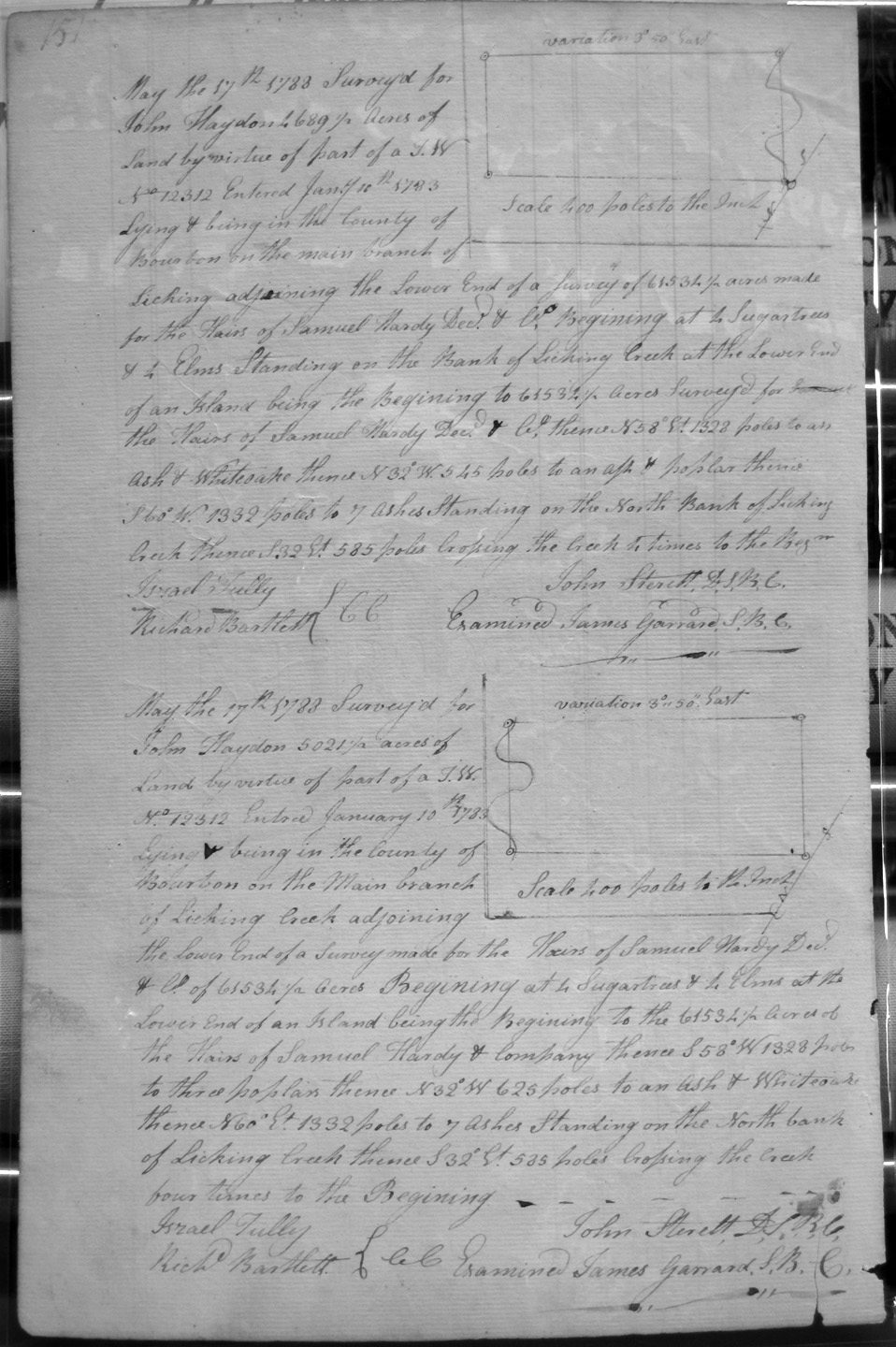
Haydon, John
17 May 1788
4,689 1/2 acres
On the Main branch of Licking adjoining the lower end of the Samuel Hardy Heirs & Co., 61.531 1/2 acre survey, and crossing the creek 4 times.
Haydon, John
17 May 1788
5,021 acres
On the Main branch of Licking adjoining the lower end of the Samuel Hardy Heirs & Co., 61.531 1/2 acre survey, and crossing the creek 4 times.
Hedgman, John
28 Apr 1789
6,250 acres
On the waters of Bigg Sandy and on the lines of James Garrard's 23,250 acre survey.
Hedgman, John
28 Apr 1789
6,250 acres
On the waters of Bigg Sandy and on the lines of Hedgman's 6,250 acre survey.
Henry, William, assignee of David Anderson
20 Mar 1789
5,300 acres
On the North side of the main Branch of Licking about 5 or 6 miles above the mouth of North Licking, adjoining a survey of 1,080 acres of Sd. Henry in the West, crossing Licking twice, and with its meanders.
Hickman, William Assignee of Daniel Henry
11 Aug 1787
20,000 (?) acres
On the waters of Sandy beginning 6 miles SE from the head of Little Sandy.
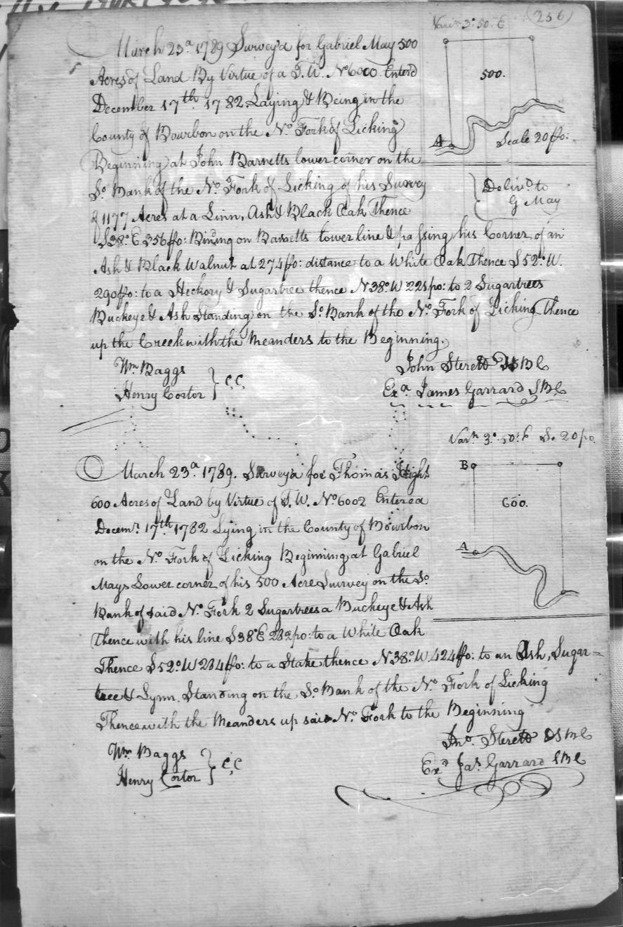
Hight (or High's), Thomas
23 Mar 1789
600 acres
On the No. Fork of Licking, beginning at the lower corner of Gabriel May's 500 acre survey on the So. Bank of the No. Fork, with his line and then meanders of the river.
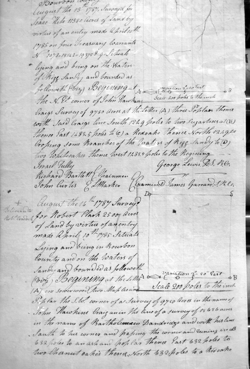
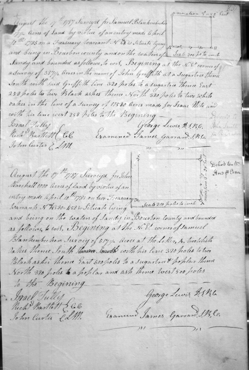
Hite, Isaac
13 Aug 1787
11,580 acres
On the waters of Bigg Sandy and on the lines of John Hawkins Craig's 9,750 acre survey,
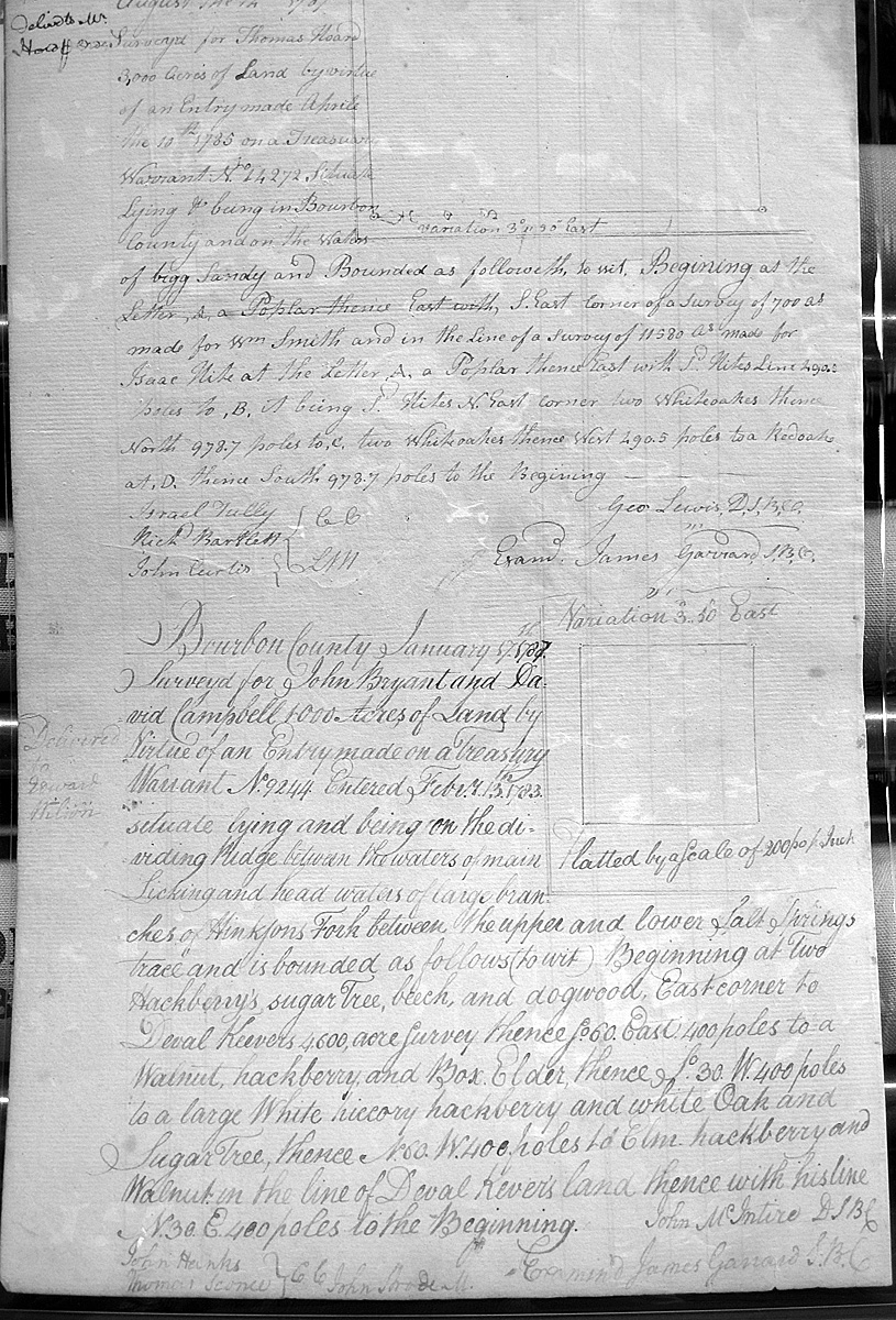
Hoars, Thomas
__ Aug 1787
3,000 acres
On the waters of Bigg Sandy and on the SE side of Wm. Smith's 700 acre survey and the line of Isaac Hite's 11,580 acre survey.
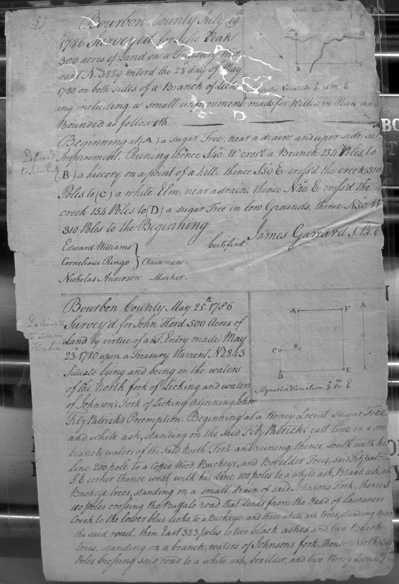
Hord, John
25 May 1786
500 acres
North Fork of Licking & waters of Johnson's Fork of Licking Adjoining FitzPatrick's Preemption
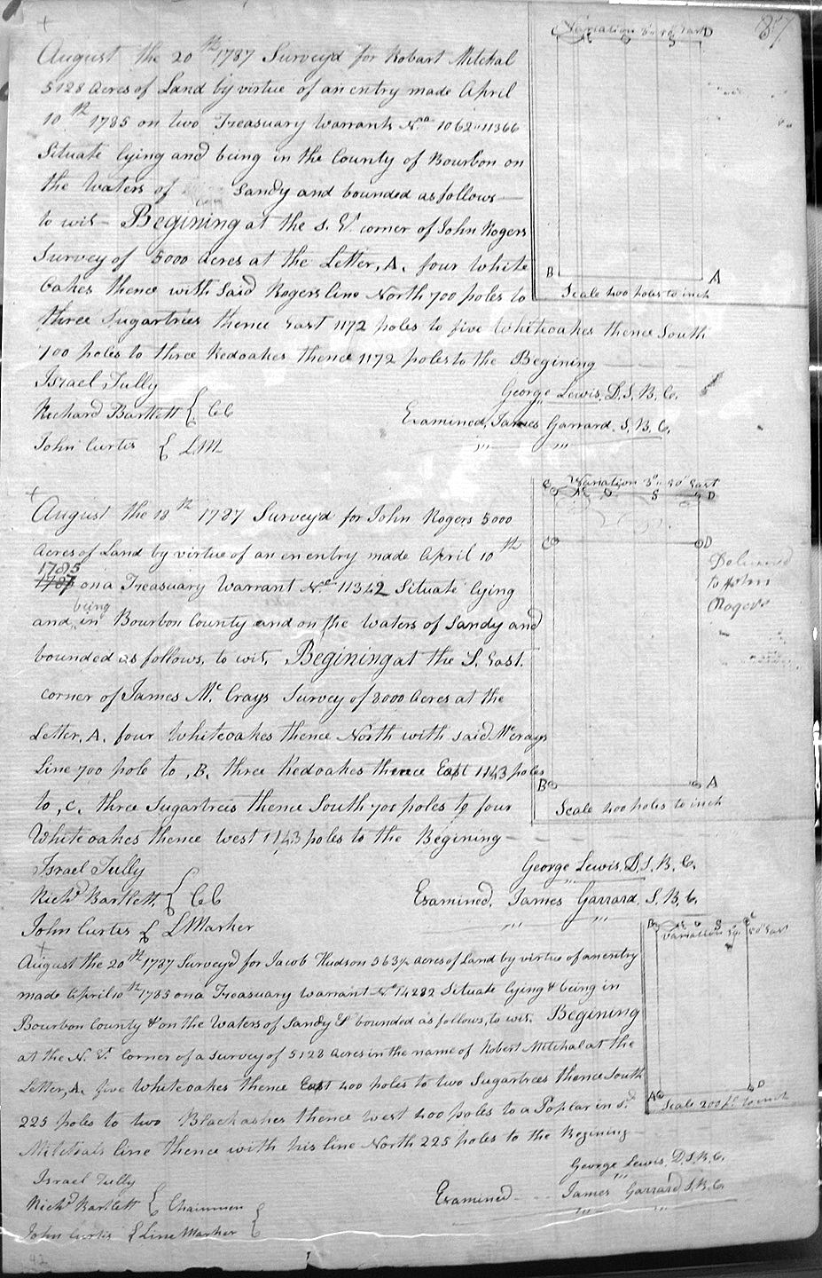
Hudson, Jacob
20 Aug 1787
564 1/2 acres
On the Sandy and on the lines of Robert Mitchal's 5, 128 acre survey.
Hughs (?), James
date unknown
799 acres
On the Red River, beginning at the SE corner of Matt Robertsons survey of 20,000 acres, and the ___ corner of Matt Walton's 9,000 acre survey,
Humble, Anthony
4 Nov 1788
2,000 acres
Lying on the waters of the North fork of Kentucky known by the name of Troublesome creek, at the lower end of James Harbinson's 590 acre survey
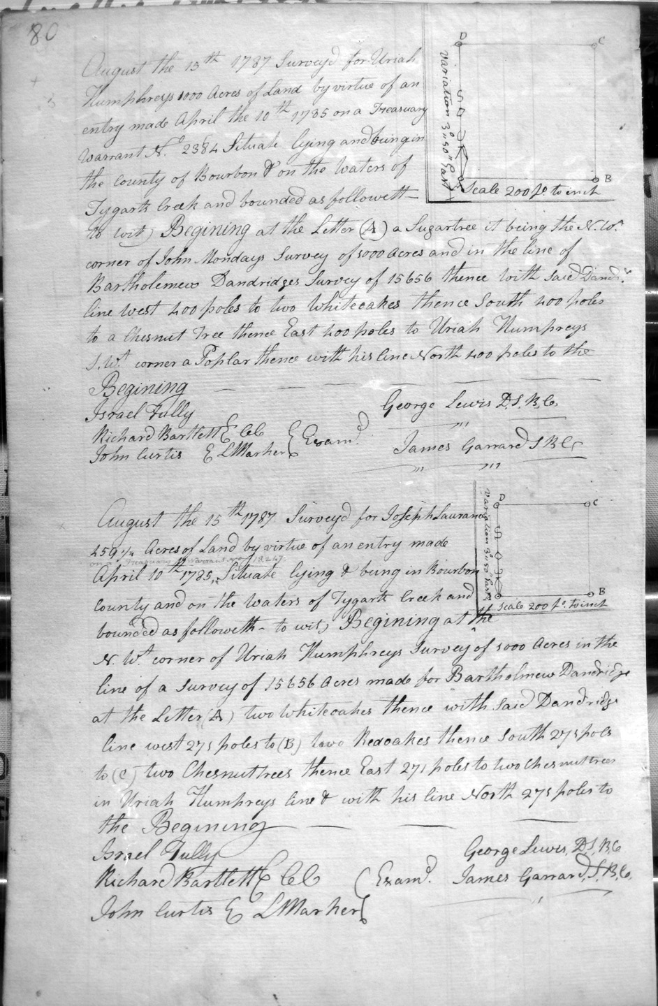
Humphreys, Uriah
13 Aug 1787
1,000 acres
On the SE corner of John Monday's 1,000 acre survey and Bartholomew Dandridge's 15,656 acre survey.
Hunter, Titus
16 Aug 1787
2,000 acres
On the waters of Sandy, and on the NE corner of Robert Clark's 9,750 acre survey and with his line to Caleb Tate's survey.
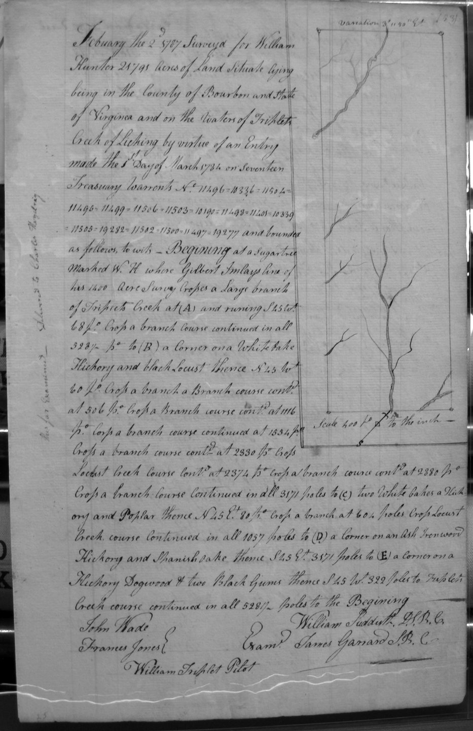
Hunter, William
2 Feb 1787
25,791 acres
In Bourbon County and the State of Virginia, on the waters of Triplet's creek of Licking on the lines of Gilbert Imlay's 1,400 acre survey, and across Locust creek course
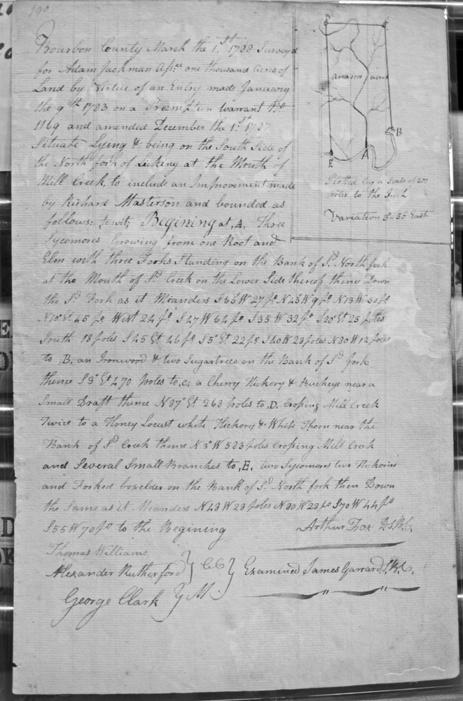
Jackman, Adam, assignee
1 Mar 1788
1,000 acres
On the South side of the North Fork of Licking at the mouth of Mill Creek to include an improvement made by Richard Masterson.
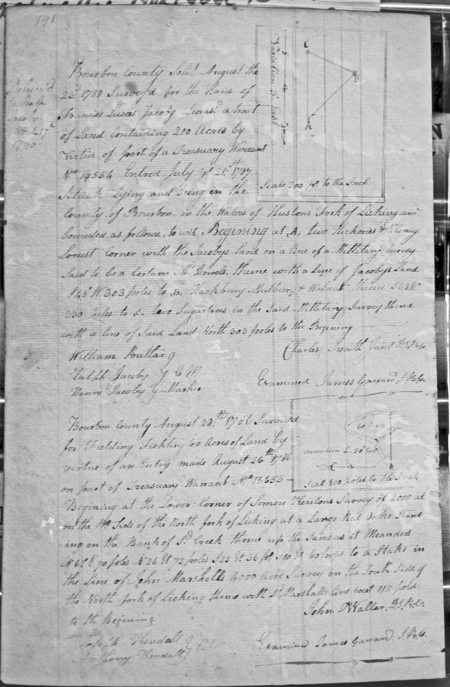
Jacoby, Francis Lucas, Heirs
23 Aug 1788
200 acres
On the waters of Huston's fork of Licking, on the lines of the Jacoby's land on the line of a Military Survey said to be a certain McDowell's. (Ralph and Henry Jacoby were two of the chain carriers and markers)
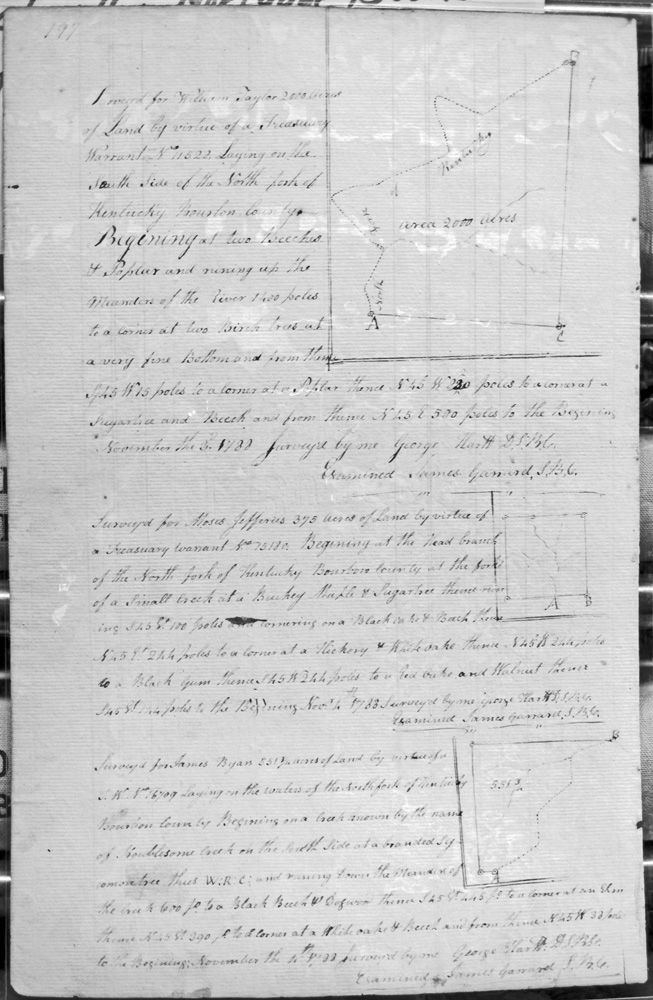
Jeffries, Moses
7 Nov 1788
375 acres
On the head branch of North fork of Kentucky.
Jenkins, James
4 Nov 1788
393 1/2 acres
On a branch running into the North fork of Kentucky, on the lines of a 1,000 acre survey of John Reed, assignee of Samuel Irwin, on the south side of the creek where it forks.
Johnson, Peter, Heir-at-Law to Jacob Johnson, deceased.
9 April 1789
1,400 acres
400 acres On the Upper Buffalo Road leading from the Blue Licks to Limestone, nine miles from said Licks on the East side of sd. Road.
And, also:
1,000 acres in four each 250 acres surveys adjoining each corner of the 400 acre survey and completely surrounding it.
Jones, John & Robert Johnson
4 Jan 1787
2,000 acres
On the waters of Bigg Sandy Creek, on the lower corner of Edward West & Robert Johnson on Sandy, across a ridge, and up the river. [Wm. Jones and Jno Curtis were chain carriers for the survey]
Keever, Deval
16 Jan 1787
4,600 acres
On the headwaters of Flemings Creek, emptying into Hinkston's Fork on the North side, on the North corner of Peter Henry's land.
Keith, Thomas
27 Apr 1789
6,500 acres
On the waters of Bigg Sandy, on the lines of the 6,000 acre survey of the Hon'l William Grason, the western corner of the 10,000 acre survey of Michael Ryan, the north corner of Peter Grant's 8,000 acre survey and his 12,058 acre survey.
Keith, Thomas
27 Apr 1789
6,500 acres
On the waters of Bigg Sandy, on the lines of the north corner of Peter Grant's 12,058 acre survey, and with Keith's other lines.
Kenton, Simon, assignee of Thomas Marshall
16 Aug 1788
2,200 acres
On the waters of North Fork of Licking and the Middle Fork of Lawrences creek, on William Wards military warrant survey, Kenton's 2,000 acre survey, the survey of John Craig and Robert Johnston, assignees of John May who was assignee of George Dickens, George Clark's survey, Craig and Johnston assignees of Maswell, Henton assignee of Joseph Frasier, and Craig and Johnston assignees of Jas. McKinley.
Kelly, Emanual, assignee of James Vaughn
29 Nov 1787
1,284 acres
On Taylor's Creek, a North branch of Hinkston, on the lines of John Dugless's [Douglas] 400 acre survey and John Tabbs's 5,000 acre survey.
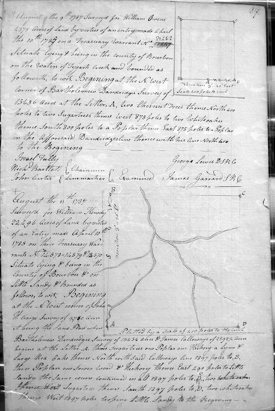
Kenedy, William
11 Aug 1787
22,496 acres
On the waters of Little Sandy and on the NW corner of John W. Craig's 9,750 acre survey, being the same place where Bartholemew Dandirdges 15,656 acre survey and James Calloway's 2,592 acre survey begin, and North with Calloway's line.
Kenny, James
10 Aug 1787
400 acres
On the North side of Stoner's fork and opposide Stoner's Improvement.
Kenton, Simon assignee of Joseph Frasier
23 May 1787
1,000 acres
On Lawrence's creek adjoining his Settlement, including Dunner's Spring.
King, John E. & William Calk Ass. Of the Sd King
5 Mar 1787
2,000 acres
On the waters of Slate creek which empties into Licking Creek on the South side Above the upper salt spring
King, John E. & William Calk Ass. Of the Sd King
5 Mar 1787
2,437 & 1/2 acres
On the waters of Licking on the SW corner of James French, and William Calks and Edward Payne, and crossing Slate Creek
Lambert, David
24 Apr 1789
9,000 acres
On the headwaters of Cabbin Creek and bounded by a gap in the Siotha Mountains, Thomas Poindexter's 10,000 acre entry,
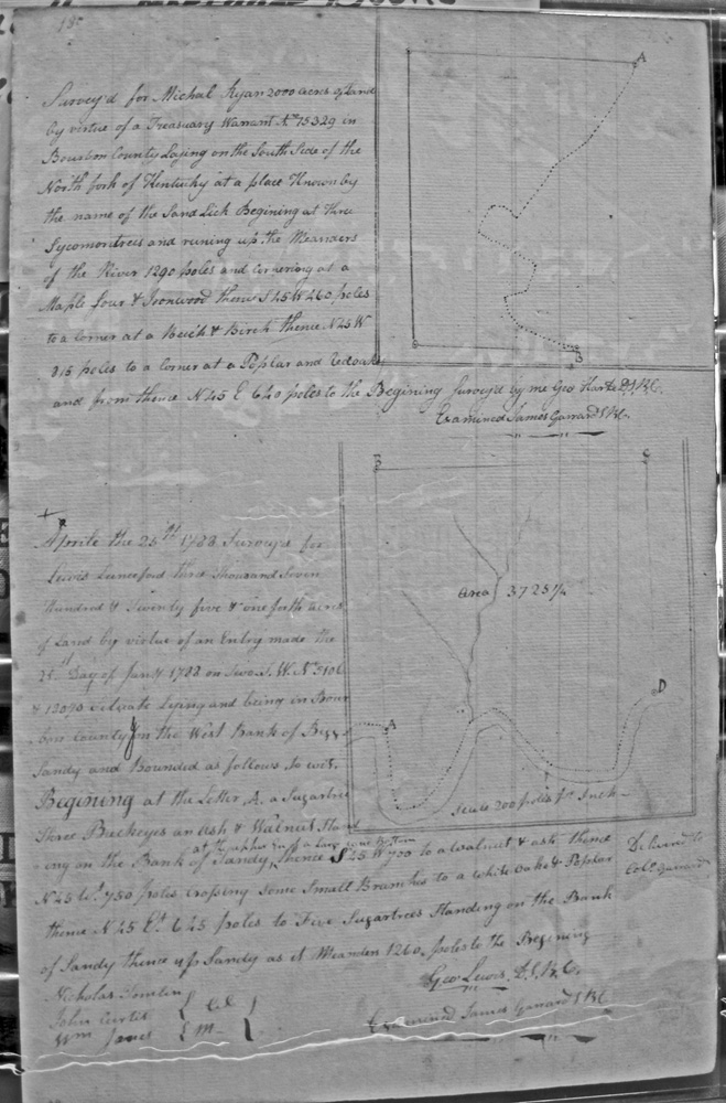
Lanceford, Lewis
25 Apr 1788
3,725 1/4 acres
On the West bank of Bigg Sandy
Laurance, Joseph
15 Aug 1787
259 1/4 acres
On the waters of Tygart's creek, and on the NW corner of Uriah Humphrey's 1,000 acre survey and Bartholomew Dandridge's 15,656 acre survey.
Laurance, Samuel
10 Aug 1787
3,000 acres
On the waters of Little Sandy, on the lines of James Calloway's 2,592 1/2 acre survey.
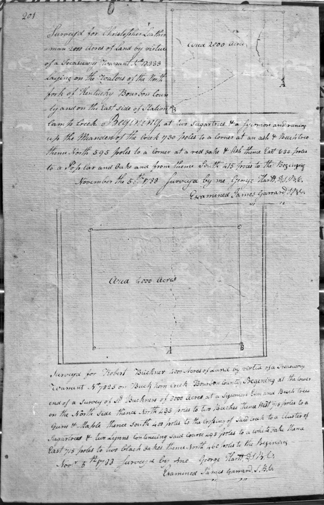
Leatherman, Christopher
5 Nov 1788
1,000 acres
On Boons hunting camp creek, at the upper end of Leatherman's 2,000 acre survey
Leatherman, Christopher
5 Nov 1788
2,000 acres
On the waters of the North fork of the Kentucky, on the East side of Station Camp Creek,
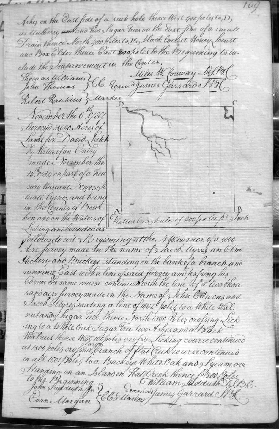
Leitch, David
6 Nov 1787
15,000 acres
On the waters of Licking, beginning on the NW corner of Jacob Myres 5,000 acre survey and John C. Owens 2,000 acre survey, crossing Licking and crossing a large branch of Flat Creek and an island in Flat Creek.
Lewis, George
8 May 1788
19,050
On the Main South fork of Big Sandy, on the lines of John May and David Ross's 25,000 acre survey and down Big Sandy.
Lewis, George and Robert Daniel, heir-at-law to Walker Daniel, deceased
28 Apr 1789
10,441 1/4 acres
On the West side of Bigg Sandy and bounded by on the lower corner (on Sandy) of James Garrard's 23,250 acre survey at the lower side of the mouth of a small creek, and the upper end of a large cane bottom and the upper corner of Lewis Lunsford's 2,725 1/4 acre survey.
Lewis, George
29 Apr 1789
250 acres
On the Waters of Bigg Sandy, and bounded by the lines of the 5,000 acres of Presley Bodine and Richard Yong (Young ?), and the 1,546 acre survey of William Richard's and Richard Young.
Lewis, Howel, Assignee of Howel Lewis, Senior
22 Feb 1787
1,000 acres
On the forks of Licking, on Samuel Meredith's corner on the bank of the South fork of Licking and Meredith's line.
Lewis, Isaac
25 Apr 1789
2,500 acres
On the waters of Bigg Sandy and bounded by George Lewis's survey of 19,050 acres, and crossing Sandy.
Lewis, Isaac, assignee of William Durrett
10 Apr 1788
2,956 acres (map shows 4,434 acres)
Beginning at the lower corner on Sandy of Lewis Lunsford's 3,725 1/2 acres,
Lewis, John
27 Jan 1785
1,000 acres
On the waters of the North fork of Licking, and adjoining the 306 acre survey of Joseph Russell on the North, and bounded by the 2,972 acre survey of John Metcalf.
Lewis, John
20 Mar 1789
290 acres
On the waters of Licking, joining John Lewis's 1,000 acre survey, on John Barnell's line, on Gabriel May's line, and the 600 acres of Thos. Wiles.
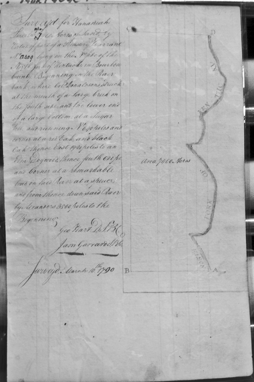
Lincoln, Hananiah
10 Mar 1790
1,460 (or 7,460) acres
On the North side of the North fork of Kentucky, beginning at the river bank where Colo. Donaldson struck, and at the mouth of a large creek, on the South side.
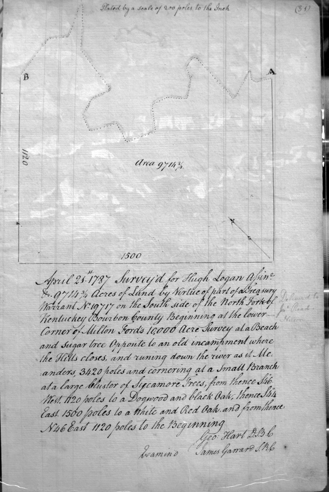
Logan, Hugh assignee
25 Apr 1787
9,714 3/4 Acres
On the South side of the North Fork of the Kentucky, on Milton Ford's 10,000 acre survey opposite to an old encampment.
Logan, Hugh
10 Nov 1788
1,695 acres
On the waters of the North fork of Kentucky and the West side of Station Camp Creek.
Logan, Hugh
22 Oct 1788
1,681 acres
On Boone's Station Camp Creek, beginning above the first laurel on the creek, and crossing the trace that leads from Clinch's settlement to the Rock House.
Loveless, John
10 Oct 1788
270 acres
On the waters of Coopers Run and Hustons Fork, branches of South fork of Licking, and bounded on the East line of William McGee's preemption,
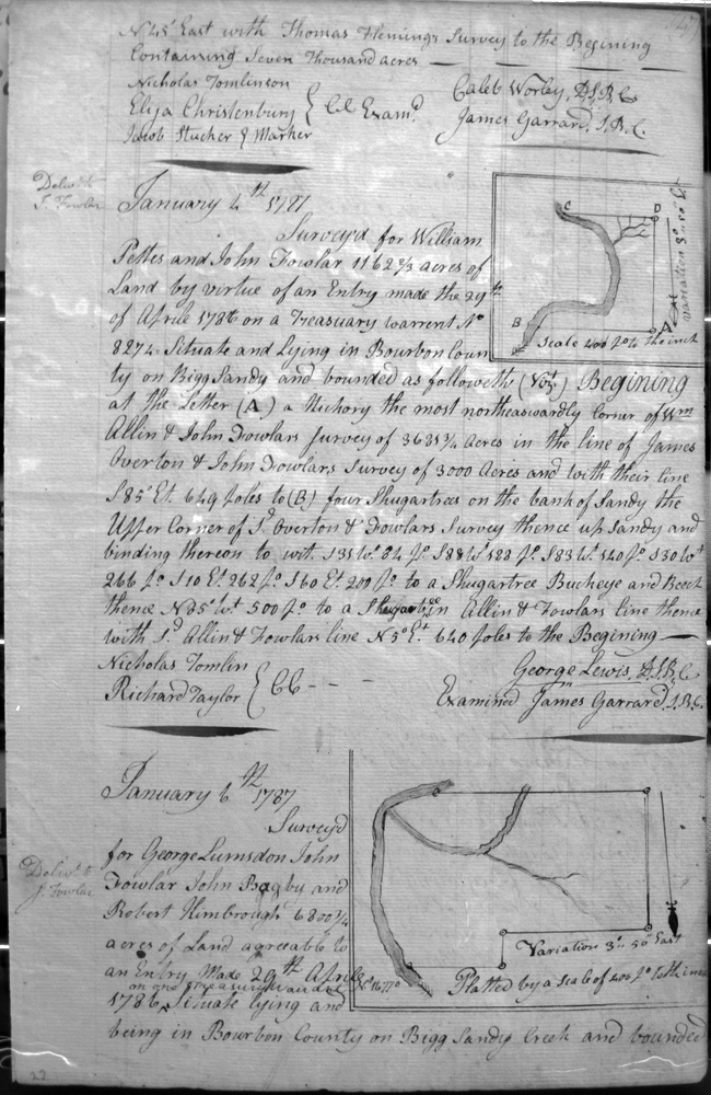
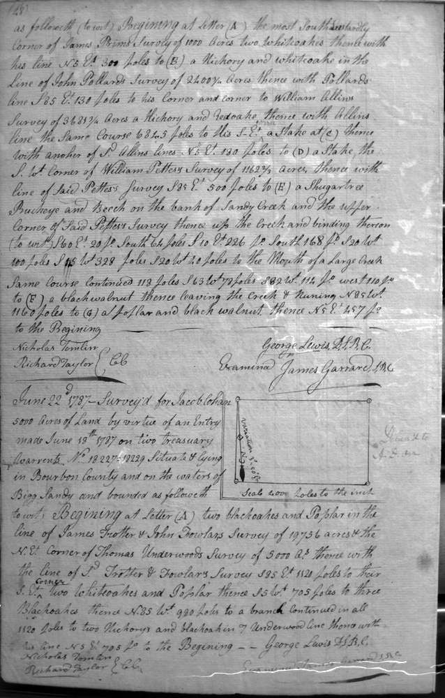
Lumsdon, George, John Fowlar, John Bagby & Robert Kimbrough
6 Jan 1787
6,800 1/4 acres
On Bigg Sandy creek, on the lines of James Brim's (?) 1,000 acre survey, John Pollard's 2,400 3/4 acre survey, William Allin's 3,681 3/4 acre survey, and William Pettis's 1,162 2/3 acre survey,
Lumsdon, George, Assignee for John Bagby, Assignee for Robert Kimbrough, Assignee for John Fowler
6 Jan 1787
2,222 3/4 acres
On Bigg Sandy, bounded by the SE corner of James Ramms survey of 1,000 acres, John Pollards 2,499 3/4 acre survey and East with his line, and Thos. Allen's survey of 3,681 3/4 acres, and William Petties survey.
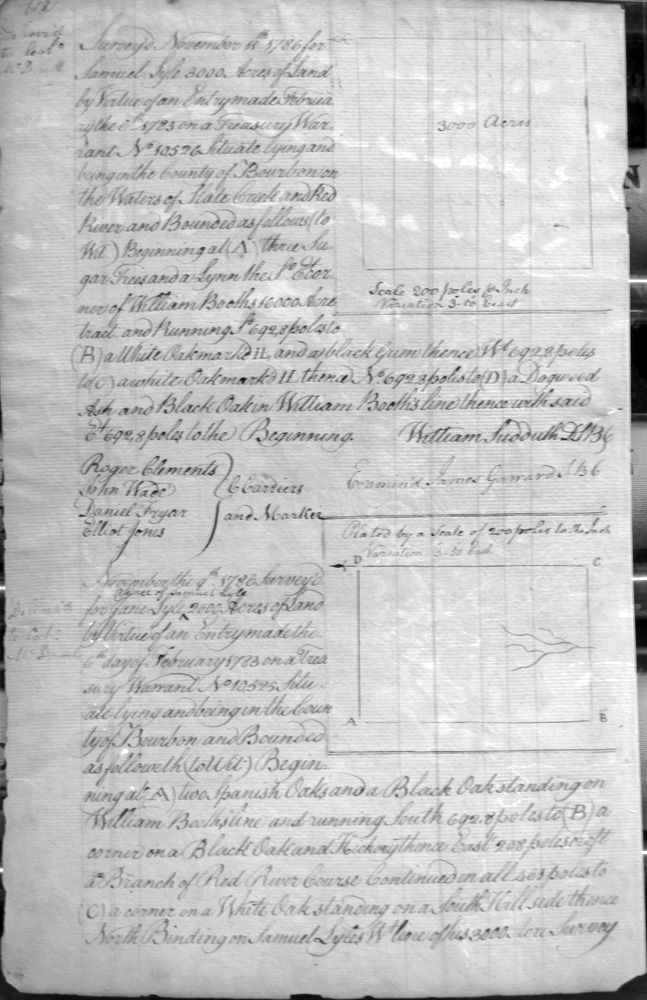
Lyle, Samuel
11 Nov 1786
3,000 acres
On the waters of Hale (?) Creek & Red River, on the lines of William Booth
Lyle, Jane
9 Sep 1786
2,000 acres
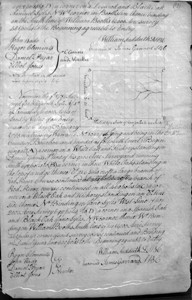
On the waters of the Red River, on the lines of William Booth and Samuel Lyle
Lyle, Elizabeth, Assignee of Samuel Lyle
9 Sep 1786
2,000 acres
On the waters of the Red River, on the lines of William Booth and Jane Lyle
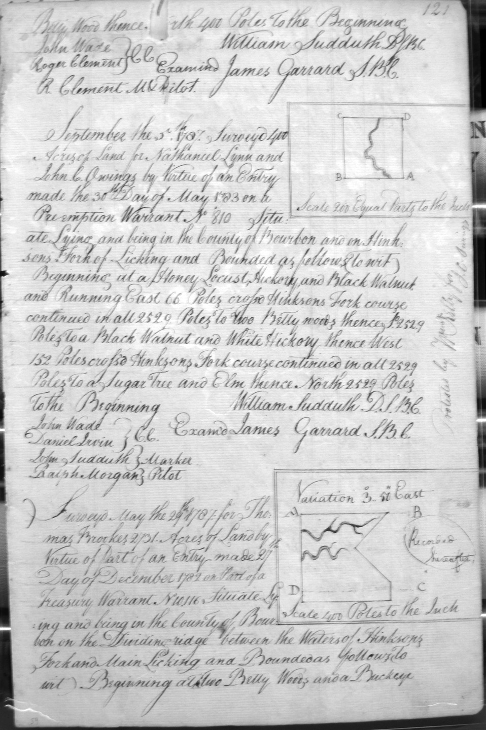
Lynn, Nathaniel & John C. Owings
4 Sep 1787
400 acres
On Hinkson's fork of Licking.
Marchland, William
2 March 1787
740 acres
On Huston's fork, and branch of South Fork of Licking on the lines of John Lyons Preemption and McDowel's (or McDaniel's) Military Survey.
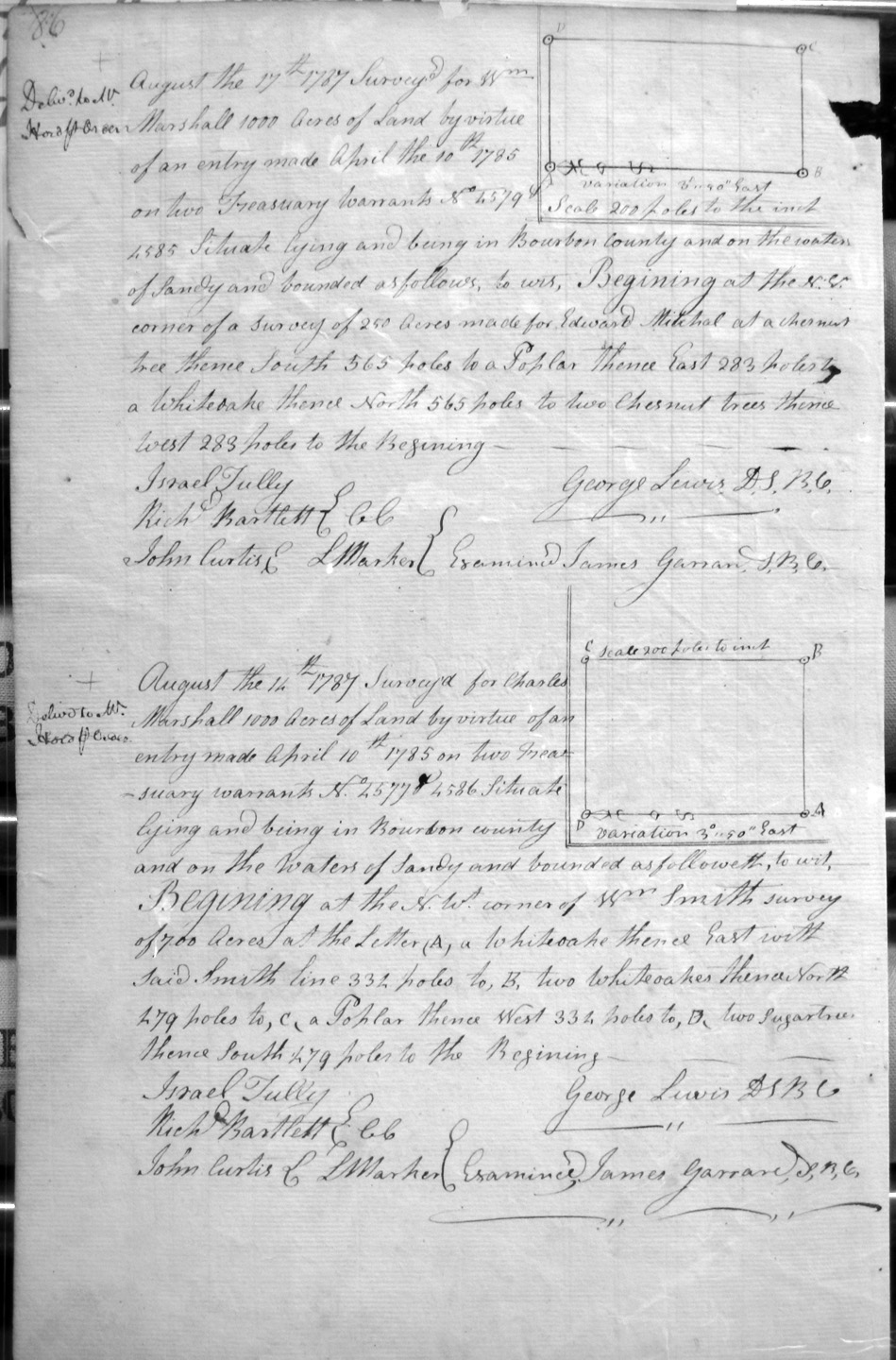
Marshall, John
17 August 1787
1,000 acres
On the waters of Sandy, and on the NE corner of Samuel Blankenbecker's 517 1/2 acre survey.
Marshall, Charles
11 Aug 1787
1,000 acres
On the Sandy River and the the NW corner of Wm. Smith's 700 acre survey
Marshall, Thomas 4,500 acres
Smith, John 3,500 acres
Smith, William 2,000 acres
3 Apr 1788
On the waters of Bigg Sandy, and bounded by the 25,000 acre survey of John May and David Ross, cornering on Lewis's survey.
Marshall, Wm.
17 Aug 1787
1,000 acres
On the Sandy River and the lines of Edward Mitchal's 250 acre survey.
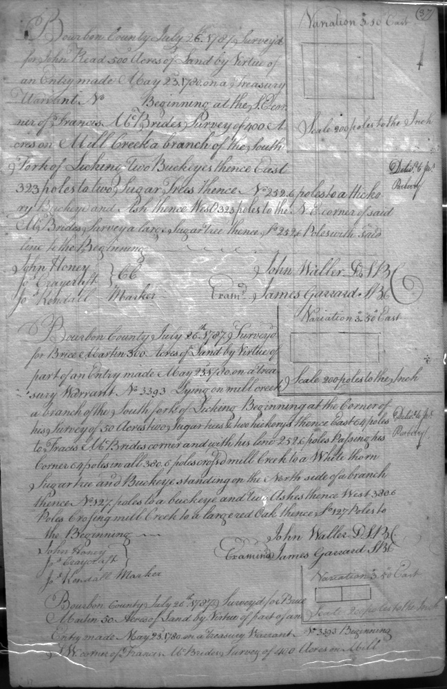
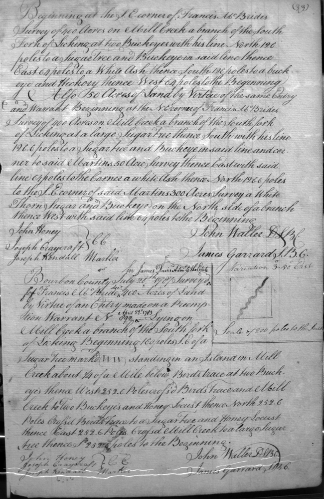
Martin, Brice
26 July 1787
300 acres
On mill creek a fork of the South fork of Licking, on the lines of his 50 acre survey and Francis McBride.
Martin, Brice
26 July 1787
50 acres
On the lines of Francis McBride's 400 acre survey on Mill creek. Also 50 acres as above.
Martin, Brice
26 July 1787
Two 50 acre sureys
On Francis McBride's 400 acre survey on Mill creek a branch of South fork of Licking
Martin, Brice
16 June 1789
500 acres
On on Mill creek, a branch of South fork of Licking, on the lines of Francis McBride.
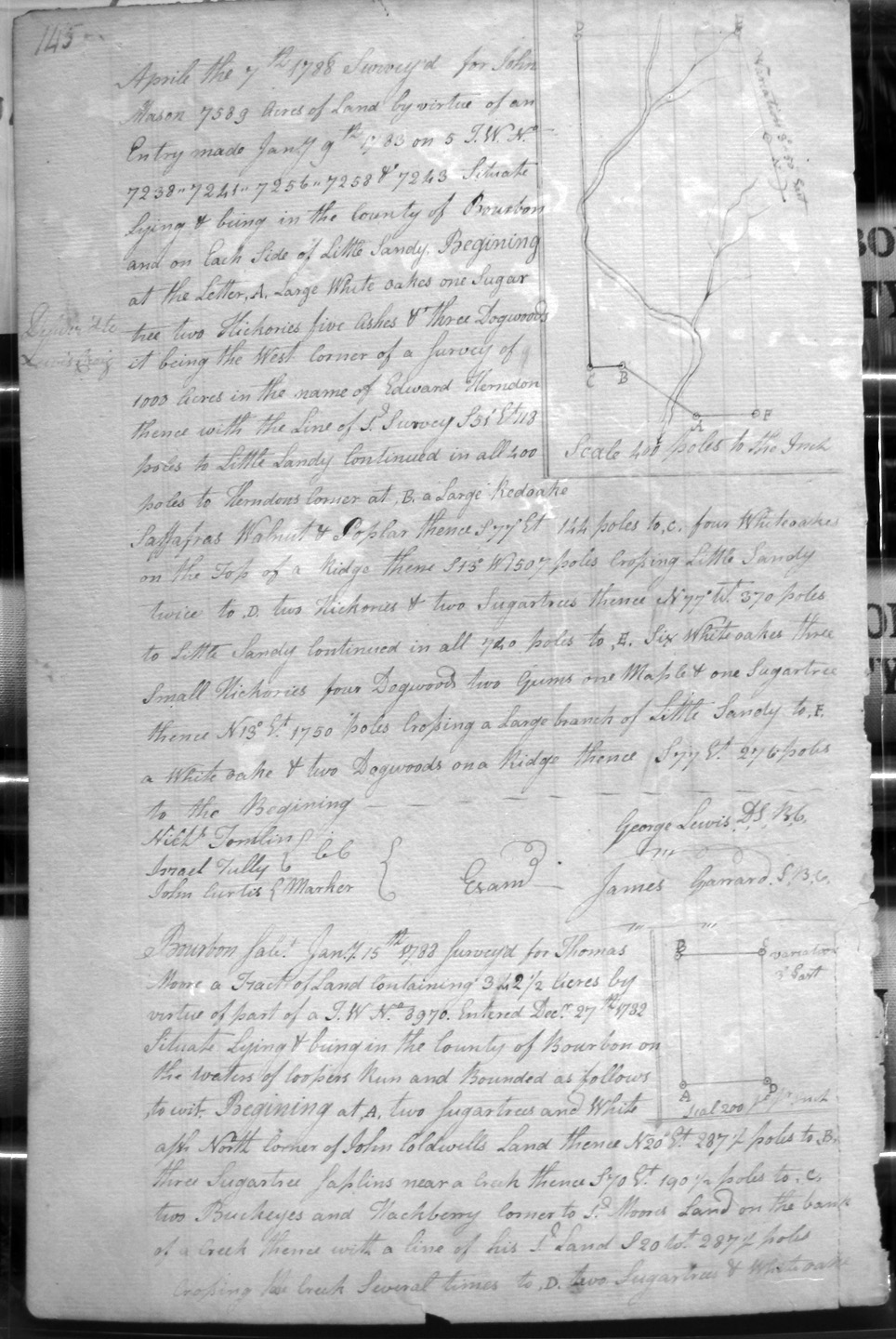
Mason, John
7 Apr 1788
7,589
On each side of Little Sandy, and on the lines of Edward Herndon's 1,000 acre survey.
Masterson, James
19 Nov 1788
1,125 1/2 acres
On Stoners Fork of Licking, and bounded by the SE corner of Timothy Peyton's 1,000 acre preemption, crossing Stoner and crossing the creek's large branch. With Jas. Masterson as MB.
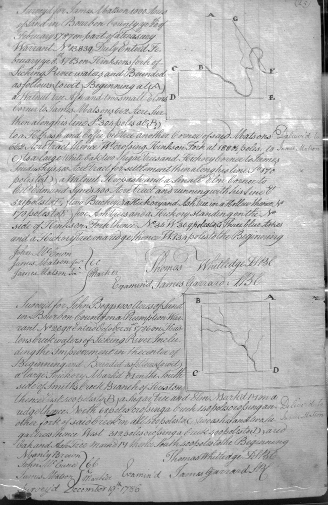
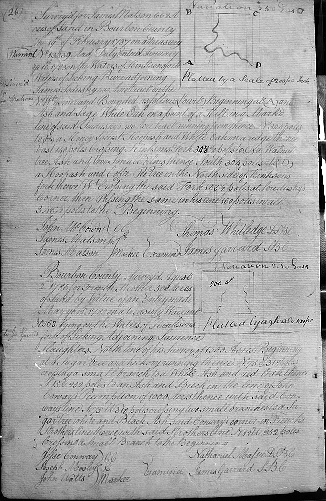
Matson, James
5 Feb 1787
1,000 acres
On Hinksons fork of Licking River waters, on the lines of James Matson's 662 acre survey, crossing Hinksons fork, and on James Sandusky's 600 acre settlement and Col. James Lyne's 400 acre tract
Matson, James
19 Feb 1787
668 acres
On the waters of Hinksons Fork of Licking, adjoining Sandusky's lines
Matsen, James
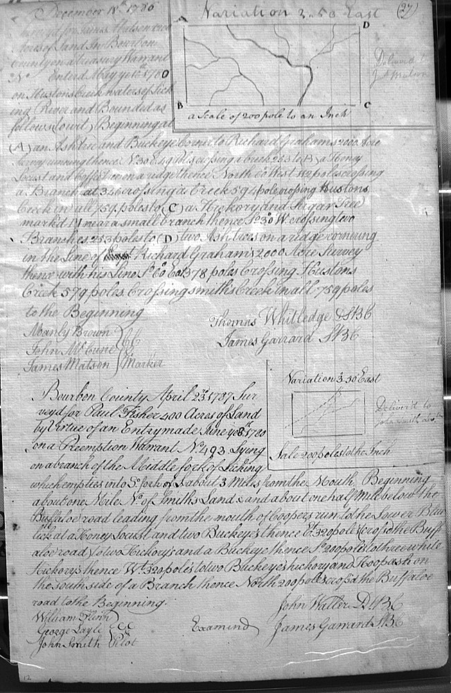
18 Dec 1780 or 1786
1200 (?) acres
On Hustons Creek, waters of Licking River, crossing Smith's creek, on a line of Richard Graham's 2,000 acres survey,
May, Gabriel Page 250 is blurry
13 Mar 1789
733 acres
On the waters of N fork of Licking, adjoining Metcalf's 2,972 acres and John Lewis's 290 acre survey.
May, Gabriel
23 Mar 1789
500 acres
On the North Fork of Licking, bounded by John Barnett's lower corner on the S. bank of the No. Fork of Licking of his survey of 1,177 acres, and with his line to a corner, and with the meanders of the creek to the beginning.
May, George
2 April 1789
15,000 acres
On the waters of Bigg Sandy and bounded by the 10,752 1/2 acre survey of John Thomas Miller, and David Ross and John May's 25,000 acre survey.
May, George
3 April 1789
31,040 1/2 acres
On the waters of Bigg Sandy and bounded by David Ross and John May's 25,000 acre survey, the 9.000 acre survey of James Clark, and George May's 15,000 acre survey.
May, George
30 April 1789
10,000 acres
On the lines of the 6,250 acre survey of John Hedgman, the west corner of the 23,250 acre survey of James Garrard, and the 10,041 acre survey of George Lewis.
May, George
28 Apr 1784
5,328 acres
Bounded by joseph Strother's 7,221 1/2 acre survey, George Davis's 19,050 acre survey, and the old line of Richard Shepherd's land, the West bank of Bigg Sandy at the mouth of a small branch then up Sandy.
May, George
29 Apr 1784
21,176 3/4 acres
On the waters of Bigg Sandy and bounded by joseph Strother's 7,221 1/2 acre survey, John Thomas Miller's 10,752 1/2 acres, and May's 5,328 acres.
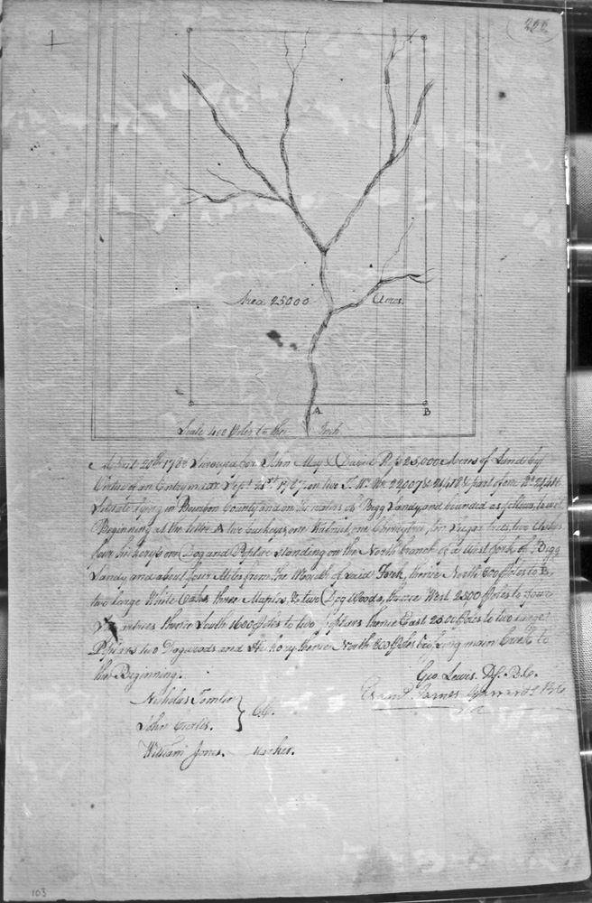
May, John & David Ross
25 Mar 1788
40,418 acres
On Shelby creek, a western branch of Sandy, and on Merry Walker's 20,000 acre survey.
May, John & David Ross
20 Apr (or Aug) 1788
25,000 acres
On the waters of Bigg Sandy, bounded by a North branch of a West fork of Bigg Sandy, with a corner about 4 miles north of the mouth of said fork.
May, John
No Date
19,241 acres
On the lines of Edmond Logwood's 10,000 acre survey, and in the line of Berfords 6,400 acre survey, the line of Alexander Dows 5,000 acres and with another of their lines, and a corner of William Marshall
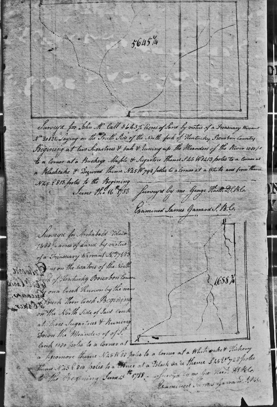
McCall, John
16 June 1783
5,645 1/2 acres
On the south side of the North fork of the Kentucky
McClung, John
11 Nov 1786
276 acres
On the west side of a branch and the South line of William McKees, Samuel Lyle's East line, and crossing a branch of Red River
McConnell, William
27 Apr 1789
200 acres
On the East fork of Licking (now called the North fork), on the North bank half a mile below the mouth of Mill Creek,
McCray, James
18 Aug 1787
8,000
On the waters of Sandy, and on the lines of SW corner of Caleb Tate's 1,000 acre survey
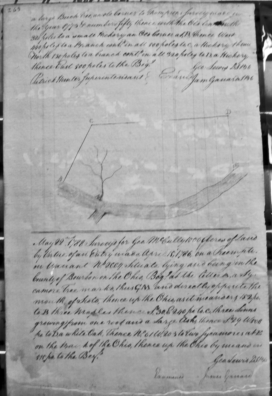
McCully, George
22 May 1788
1,000 acres
On the Ohio directly opposite Scoto, then up the Ohio with its meanders.
McCune, William
25 Apr 1789
400 acres
Adjoining John Woods and Moses Moses Preemption on the NW side, a drain of Grays Run. The two chain carriers are David and John McCune.
McDonald, Enos
29 Apr 1789
250 acres
On the West side of Bigg Sandy and corner to William Robinson's and Co. 15,246 acre survey, and up the Sandy.
McDowell, James
20 Dec 1788
1,000 acres
On the waters of East Fork of Licking about eight miles from the Lower Blue Licks, beginning at William McDowell's SWest corner of 1,000 acres.
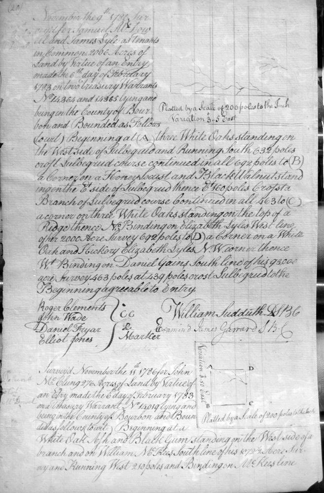
McDowell [or Dowall], Samuel M. and James Lyle, as tenants in common
9 Nov 1786
2006 acres
On Lulbegrud (?) and Elizabeth Lyle's West line and NW corner, and Daniel Gains South line
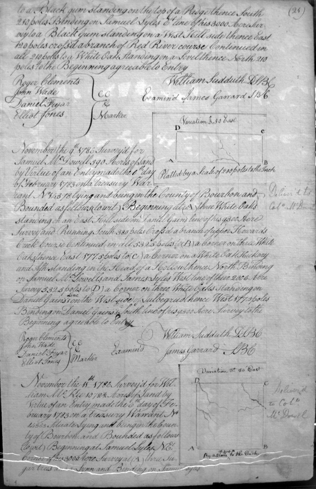
McDowell, Samuel
9 Nov 1786
390 or 590
East of Daniel Gains' line, a branch of upper Howard's creek, on the North adjoining Samuel M. McDowell and James Lyles West line, and Daniel Gains South line of his 9300 acre survey
McDowell, Sam'l
April ????
100 (?) acres
On the waters of the East fork of Licking Creek, beginning at the SW corner of John Williams preemption in the line of Elizabeth Stephenson and difficult to read after that.
McDowell, William
20 Dec 1788
1,000 acres
On the waters of East fork of Licking Creek, beginning 2 miles below the Preemption of Hugh Shannon on the North side of the creek on the bank of sd creek, and crossing the creek.
McGill, William
4 Nov 1788
1,368 1/2 acres
On the North side of the North fork of Kentucky and with the meanders of the river.
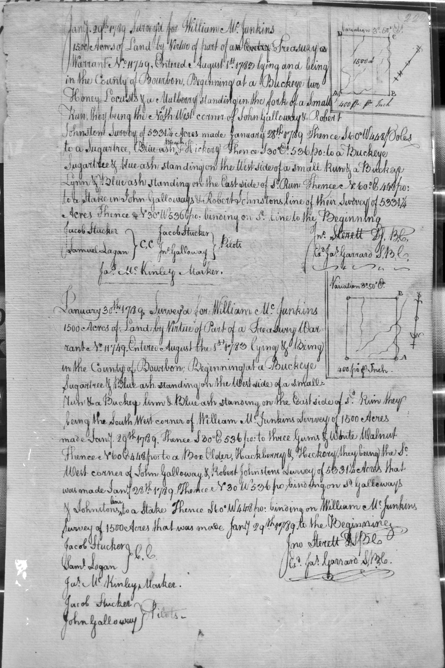
McJunkins, William
29 Jan 1789
1,500 acres
On a small run at the NW corner of John Galloway and Robert Johnston's 5,331 acre survey made Jan 28, 1789.
McJunkins, William
30 Jan 1789
1,500 acres
On the SW corner of William McJunkins survey of 1,500 acres and the SW corner of John Galloway and Robert Johnston's 5,331 acre survey made Jan 28, 1789.
McKee, William
11 Nov 1786
1,072 1/2 or 10,725 acres
On the lines of Lyle's 3000 acre survey, and crossing a branch of Slate creek course,
McKeltrich, Anthony
31 Oct 1786
1,517 (?) acres
Adjoining the SW side of Arthur See's survey on Willow Creek, on the banks of Main Licking
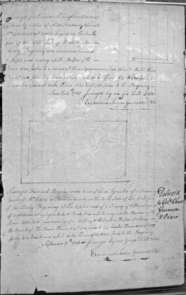
McLaughlin, Duncan
16 June 1782
1,300 acres
On the south side of the North fork of the Kentucky
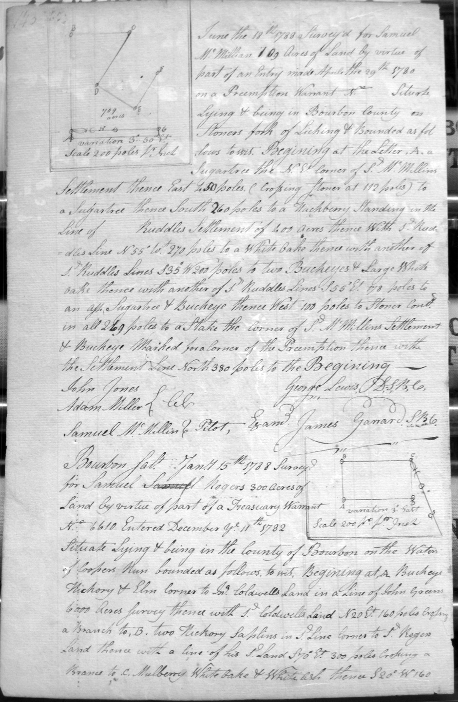
McMillian, Samuel
17 June 1788
709 acres
On Stoner's fork of Licking, and on the NE corner and a line of S'l McMillan's Settlement, and on the lines of Ruddle's 400 acre Settlement,
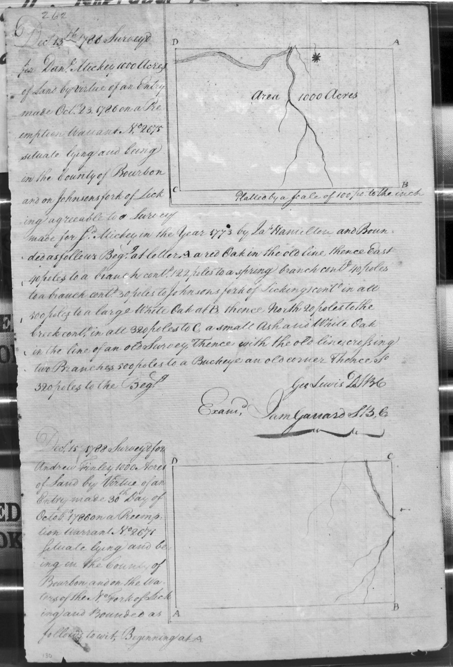
Mickie (or Mickey), Dan'l
13 Dec 1788
1,000 acres
On Johnsons fork of Licking agreeable to a survey made for said Mickey in 1773 by Jas. Hamilton.
Mills, Edward
26 Mar 1789
2,000 acres
Situate, lying and being on the Ohio Hills and River Bottom, bounded by a fork of Lee's Creek, crossing Lee's Creek several times, and on the Mouth of Lee's Creek.
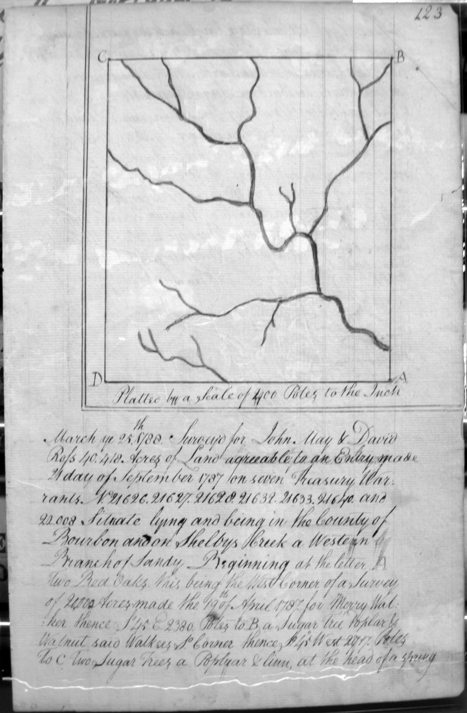
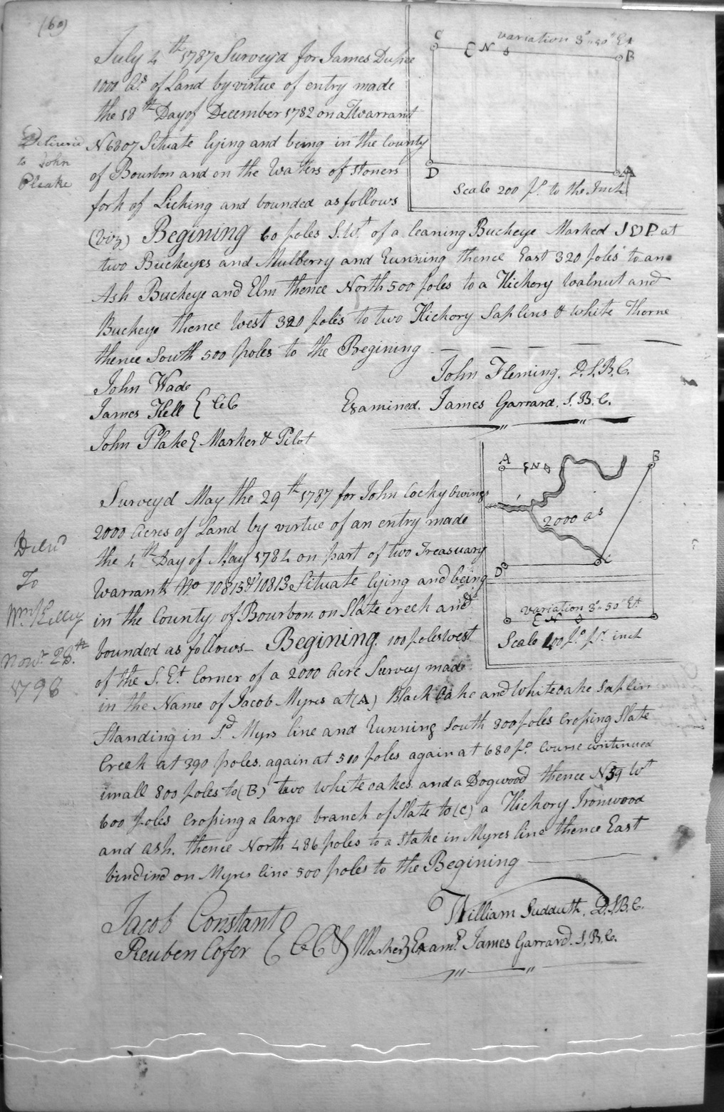
Miller, John and Thomas, as tenants in common
2 Apr 1788
10.752 1/2 acres
On the waters of Bigg Sandy, and bounded by Joseph Strothers' 7,221 1/2 acre survey cornering to William Miller's 1,000 acre survey and to another of his lines, and on the line of the 25,000 acre survey of John May and David Ross
Miller, William
2 apr 1788
1,000 acres
On the waters of Bigg Sandy and bounded by a 25,000 acre survey of John May & David Ross, and Joseph Strother's 7,221 1/2 acre survey.
Mitchal, Edward [Mitchell (?)]
18 Aug 1787
500 acres
250 acres on the waters of Sandy, and on the lines of the SW corner of Samuel Blankenbeeker's 517 1/2 acre survey; also, 250 acres on the SW corner of Edward Mitchall's 250 acre survey. Both, part of same survey.
Mitchal, Robert
20 Aug 1787
5,128 acres
On the Sandy and on the lines of John Rogers 5,000 acre survey
Monday, John
10 Aug 1787
3,041 1/4 acres
On the waters of Tygart's creek, on the lines of the Trustees of Russell Parish's 2,718 3/4 acre survey, and Samuel Laurence's 3,000 acre survey.
Monday, John
10 Aug 1787
1,000 acres
On the SE corner of Bartholomew Dandridge's 15,656 acre survey.
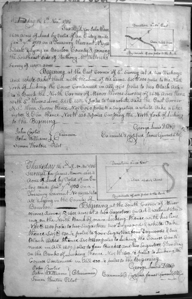
Monroe, James
2 Nov 1786
4,242 & 1/2 acres
South corner of Minor Winn's survey on the North bank of Licking
Monroe, James
12 Aug 1787
42,656 acres
On the lines of Hawkins and Stewart's 62,306 acre survey assignees of Wm Waddy and Dabney Minor
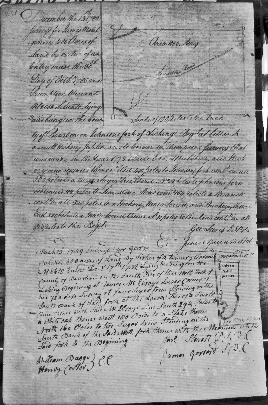
Montgomery, James
13 Dec 1788
1,000 acres
On Johnsons Fork of Licking, bounded by an old corner in Thompson's 1773 survey, Johnson's fork, and the Limestone Road.
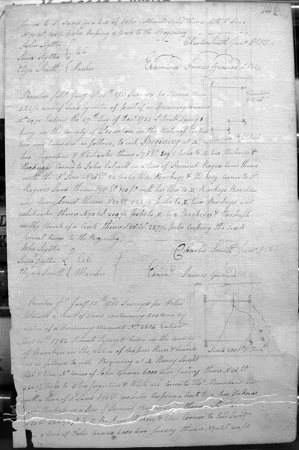
Moore, Thos.*
15 Jan 1788
342 1/2 acres
On the waters of Cooper's Run on the north corner of John Coldwell's land, and on the lines of Sd. Moore's land.
Moore, Thos.*
15 Jan 1788
342 1/2 acres
On the waters of Cooper's Run on the North__st corner of John Coldwell's land and S'l Rogers's land.
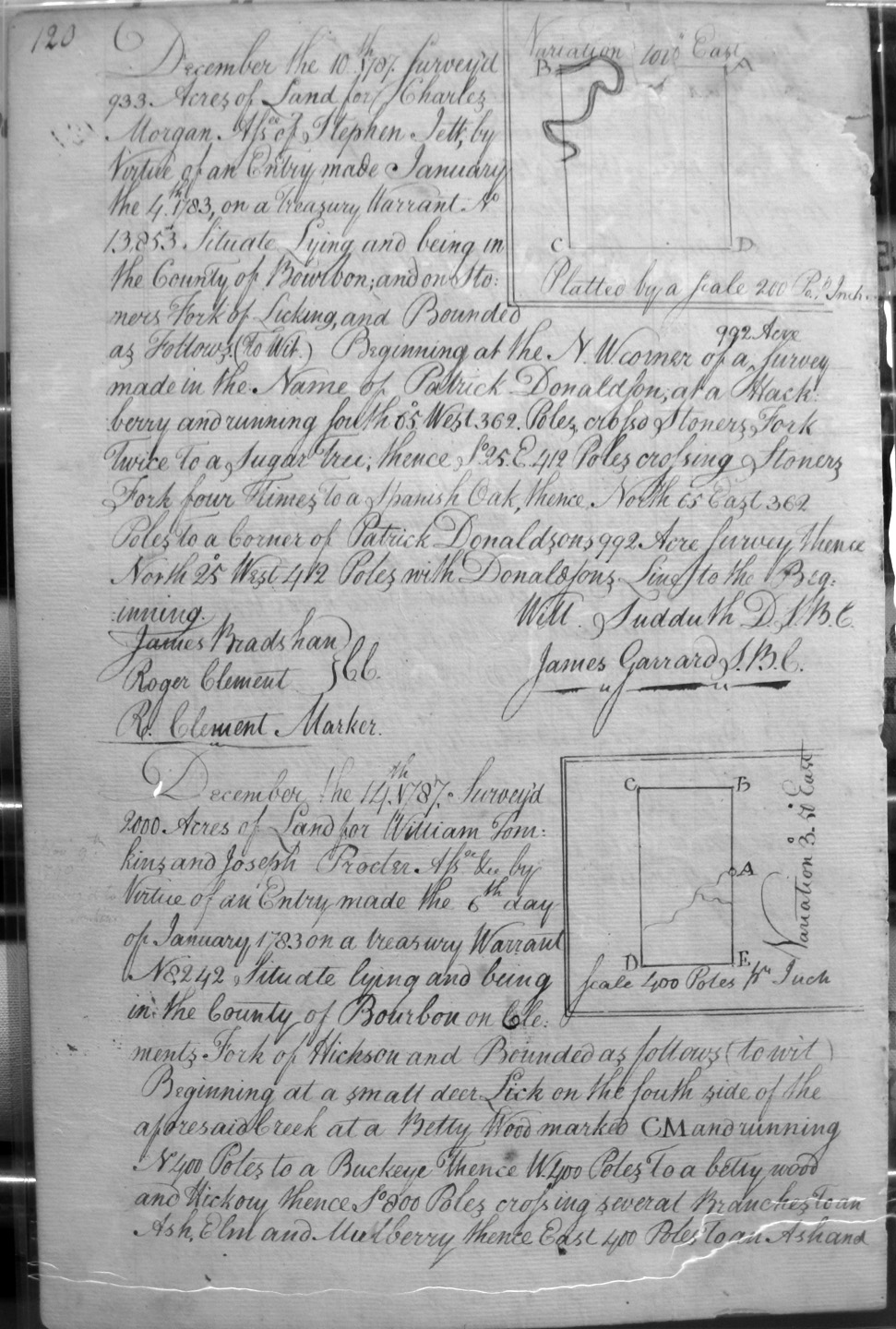
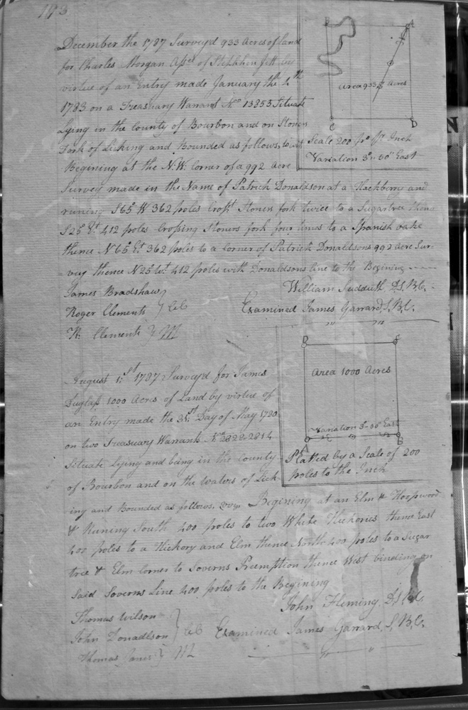
Morgan, Charles, Assignee of Stephen Jett
10 Dec 1787
933 acres
On Stoner's fork of Licking, and on the NW corner of Patrick Donaldson's 992 acre survey.
Morgan, Charles, Assignee of Stephen Jett
Page 193 (appears to be repeat of page 120 above)
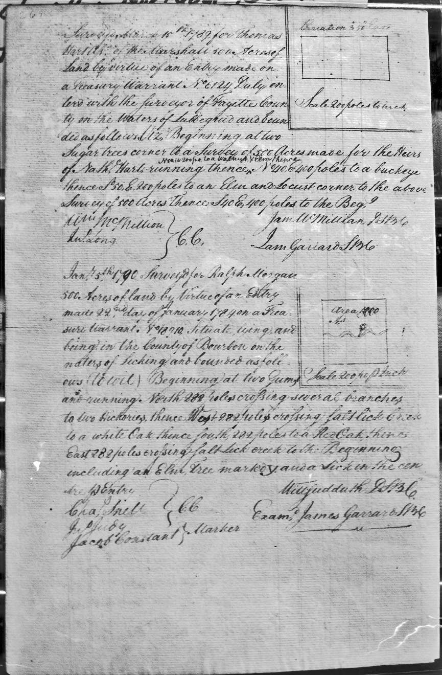
Morgan, Ralph
5 Jan 1790
500 acres
On the waters of Licking and crossing several branches and Salt Lick Creek twice, with a Lick in the center of the entry.
Morgan, Simon
13 Dec 1787
1,000 acres
On Stoner's fork of Licking to include a Lick.
Mountjoy, Edmund
1 Jan 1787
1,000 acres
On the waters of Bigg Sandy, corner William Grason's survey of 70,000 acres, Rich'd Grayham's survey of 138,320 acres,
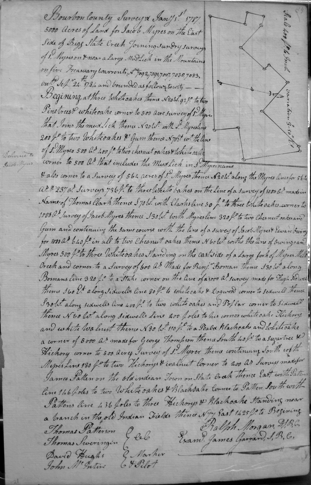
Myars (or Myres), Jacob
3 Jan 1787
500 acres
On the mud Lick Creek, a branch of Main Licking, on the lines of Myar's 300 acre survey that includes the Bigg mud Lick,
Myars (or Myres), Jacob
1 Jan 1787
5,000 acres
On the east side of Bigg Slate Creek and adjoining sundry surveys of sd. Myars, and near a large Mudd Lick in the Mountains, and on the lines of Thomas Clark's 5,000 acre survey, Jacob Myars and Edward Owings 1,000 acre survey, Benj. Boman's 600 acre survey, Hugh Sidwell's 1,000 acre survey, George Thompson's 5,000 acre survey, James Patten's 200 acre survey on the old indian Town on Slate Creek, and a branch in the old Indian Fields.
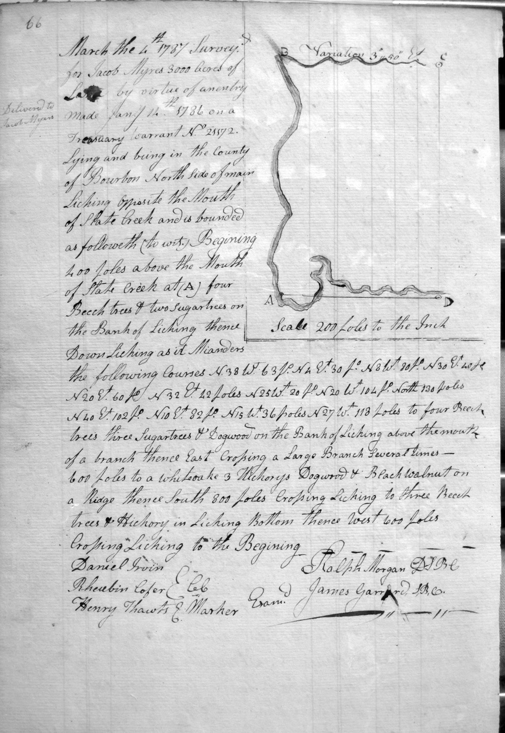
Myars (or Myres), Jacob
4 Mar 1787
300 acres
On the north side of main Licking opposite the mouth of Slate Creek, on the meanders of Licking and crossing Licking, crossing a branch several times, and on Licking Bottom.
Myres, Jacob, assignee of John Peters
8 Jan 1789
1,000 acres
500 acres on Johnston's fork of Licking at the SW corner of sd. Peters settlement, and also 500 acres on the east corner of the 500 acre survey just described, John Peters settlement, and Charles Campbell's 2,000 survey.
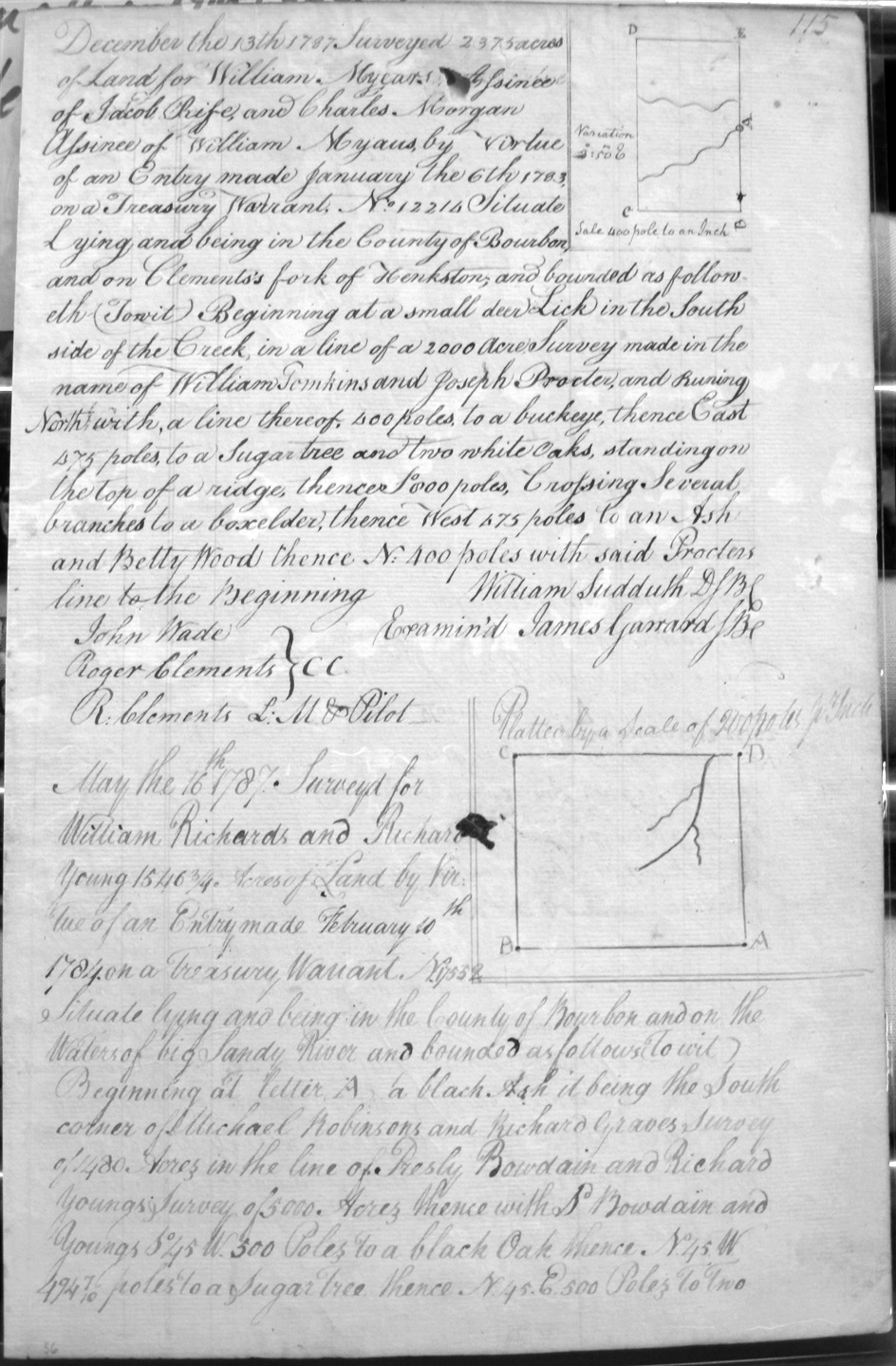
Myears (or Myars), William, Assignee of Jacob Rife and Charles Morgan, Assignees of William Myars
13 Dec 1787
2,375 acres
On Clement's fork of Hinkston, on a small deer lick on the South side of the creek, on the lines of William Tomkins and Joseph Procter's 2,000 acres.
Nall, William
16 Oct 1787
7,000 acres
On the waters of Stoner's Fork of Licking, including the Improvements in the names of Peter and Henry Hegings.
Neal, Benjamin, assignee of Talliaferro Sumate
16 Sep 1789
2,000 acres
On the head of the first branch that runs into Middle Licking above its junction with Hingsons (Hinkson) fork, beginning a mile above the Road that leads to the Forks.
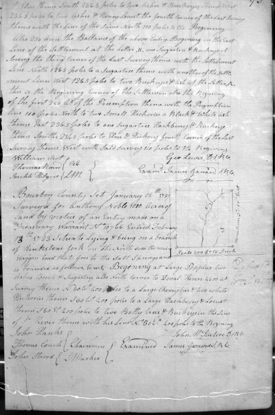
Noble, Anthony
16 Jan 1787
1,000 acres
On a branch of Hinkson's fork on the North side of the Main Waggon Road that goes to the Salt Springs on the North corner of Deval Rivers's 4,600 acres.
Osburn, Ress (?)
22 Aug 1787
3,000 acres
On the waters of Tygart's creek and on the lines of Mark Godes 2,095 acre survey.
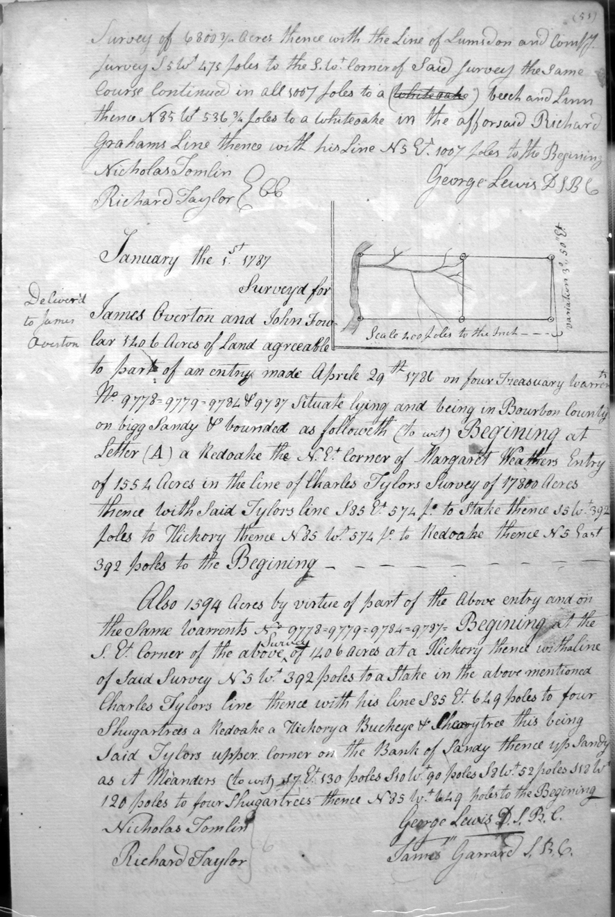
Overton, James and John Fowlar
1 Jan 1787
1,406 acres
On Bigg Sandy on the lines of Margaret Weathers' entry for 1554 acres and Charles Tylor's 17,800 acres.
Overton, Samuel
20 Aug 1787
4,000 acres
Lying on Quchland Creek on the lower side of Noss and Curry's 12,000 acres.
Owens, William
9 Aug 1787
2,375 acres
On the waters of Tygart's creek and on the NW corner of Bartholemew Dandridge's 15,656 acre survey
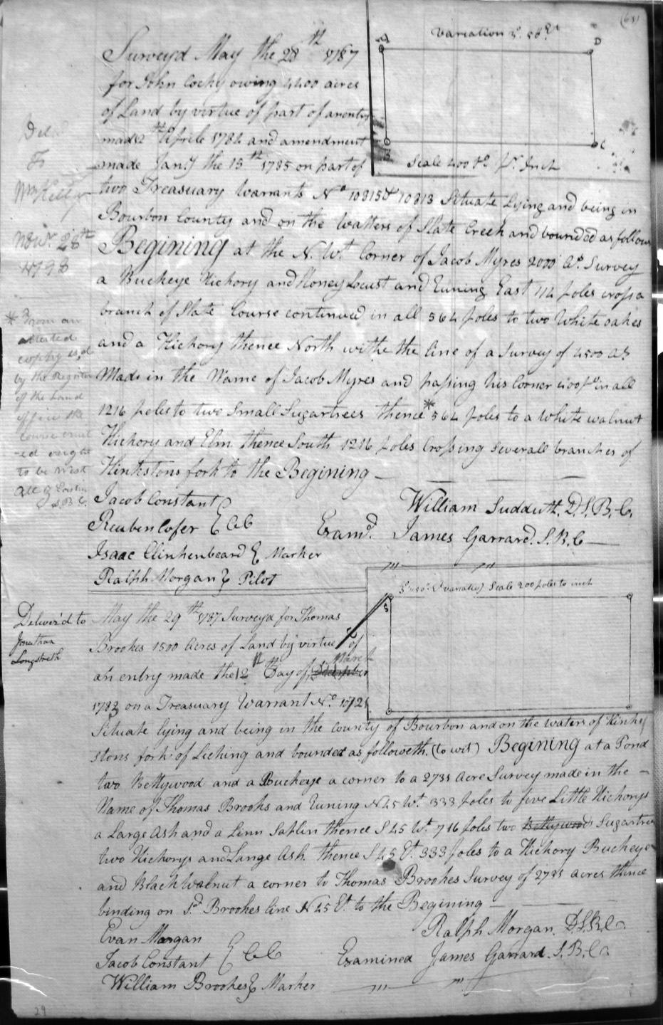
Owings, John Cocky
29 May 1787
On the waters of Slate Creek and on the lines of Jacob Myars 2,000 acre survey,
Owings, John Cocky
29 May 1787
2,000 acres
On the lines of Jacob Myars 2,000 acre survey and crossing Slate Creek.
Owing, John Cocky
28 May 1787
4,400 acres
On the waters of Slate Creek and Jacob Myars 2,000 acre survey, Myars 4,500 acre survey, and crossing several branches of Hinkston's fork.


